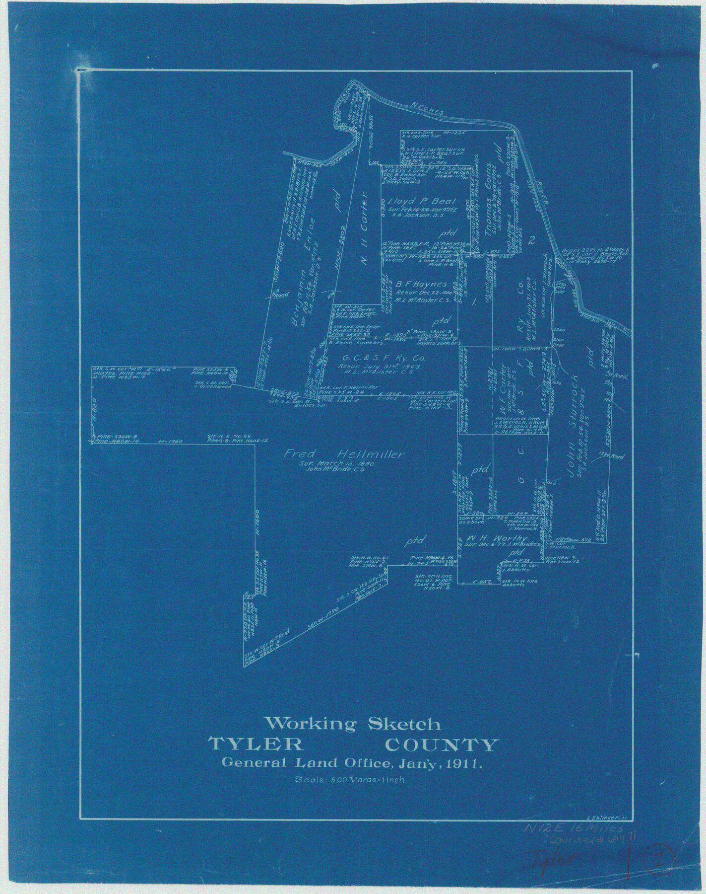
Tyler County Working Sketch 1
-
Map/Doc
69471
-
Collection
General Map Collection
-
Object Dates
1/1911 (Creation Date)
-
People and Organizations
L. Ehlinger (Draftsman)
-
Counties
Tyler
-
Subjects
Surveying Working Sketch
-
Height x Width
19.0 x 15.0 inches
48.3 x 38.1 cm
-
Scale
1" = 500 varas
Part of: General Map Collection
Pecos County Working Sketch 35

Print $20.00
- Digital $50.00
Pecos County Working Sketch 35
1939
Size 32.5 x 26.7 inches
Map/Doc 71507
Map of Hidalgo County

Print $20.00
- Digital $50.00
Map of Hidalgo County
1880
Size 45.3 x 25.1 inches
Map/Doc 3667
Terrell County Rolled Sketch 22

Print $20.00
- Digital $50.00
Terrell County Rolled Sketch 22
1903
Size 27.1 x 24.1 inches
Map/Doc 7930
Real County Working Sketch 35

Print $20.00
- Digital $50.00
Real County Working Sketch 35
1949
Size 27.7 x 23.6 inches
Map/Doc 71927
[Three-Marine League line stipulation as determined by US Supreme Court, October 1968 term; corrections to stipulation; Texas GLO approximations of county areas embraced by county boundaries, shoreline and 3-marine league line and 3-mile line]

Print $64.00
[Three-Marine League line stipulation as determined by US Supreme Court, October 1968 term; corrections to stipulation; Texas GLO approximations of county areas embraced by county boundaries, shoreline and 3-marine league line and 3-mile line]
1962
Size 13.4 x 8.7 inches
Map/Doc 61371
Aransas County Working Sketch 26

Print $20.00
- Digital $50.00
Aransas County Working Sketch 26
1965
Size 40.8 x 29.4 inches
Map/Doc 67193
El Paso County Working Sketch 11

Print $40.00
- Digital $50.00
El Paso County Working Sketch 11
1955
Size 49.2 x 43.4 inches
Map/Doc 69033
Pecos County Working Sketch 114

Print $40.00
- Digital $50.00
Pecos County Working Sketch 114
1972
Size 75.7 x 38.0 inches
Map/Doc 71587
Intracoastal Waterway in Texas - Corpus Christi to Point Isabel including Arroyo Colorado to Mo. Pac. R.R. Bridge Near Harlingen

Print $20.00
- Digital $50.00
Intracoastal Waterway in Texas - Corpus Christi to Point Isabel including Arroyo Colorado to Mo. Pac. R.R. Bridge Near Harlingen
1933
Size 27.9 x 40.8 inches
Map/Doc 61862
Jefferson County Rolled Sketch 21

Print $20.00
- Digital $50.00
Jefferson County Rolled Sketch 21
Size 12.0 x 12.1 inches
Map/Doc 6387
Gregg County Sketch File 7

Print $20.00
- Digital $50.00
Gregg County Sketch File 7
1931
Size 42.9 x 34.8 inches
Map/Doc 10466
In the Supreme Court of the United States, The State of Oklahoma, Complainant vs. The State of Texas, Defendant, The United States of America, Intervener, Red River Valley, Texas and Oklahoma Between the 98th and 100th Meridians in Five Sheets, 1921

Print $40.00
- Digital $50.00
In the Supreme Court of the United States, The State of Oklahoma, Complainant vs. The State of Texas, Defendant, The United States of America, Intervener, Red River Valley, Texas and Oklahoma Between the 98th and 100th Meridians in Five Sheets, 1921
1921
Size 37.7 x 60.2 inches
Map/Doc 75277
You may also like
Travis County Rolled Sketch 30

Print $20.00
- Digital $50.00
Travis County Rolled Sketch 30
1943
Size 26.5 x 25.6 inches
Map/Doc 8032
Hill County Sketch File 9

Print $4.00
- Digital $50.00
Hill County Sketch File 9
1857
Size 8.3 x 10.3 inches
Map/Doc 26476
Crockett County Sketch File 81

Print $4.00
- Digital $50.00
Crockett County Sketch File 81
1939
Size 11.3 x 8.5 inches
Map/Doc 19893
Lynn County Sketch File A1

Print $12.00
- Digital $50.00
Lynn County Sketch File A1
1903
Size 12.7 x 8.2 inches
Map/Doc 30464
Throckmorton County Working Sketch 3

Print $20.00
- Digital $50.00
Throckmorton County Working Sketch 3
1924
Size 19.8 x 23.8 inches
Map/Doc 62112
[Letter regarding surveys in Coryell County]
![69754, [Letter regarding surveys in Coryell County], General Map Collection](https://historictexasmaps.com/wmedia_w700/maps/69754.tif.jpg)
Print $2.00
- Digital $50.00
[Letter regarding surveys in Coryell County]
1846
Size 7.7 x 6.4 inches
Map/Doc 69754
[Surveys in the Bexar District along the Cibolo Creek]
![98, [Surveys in the Bexar District along the Cibolo Creek], General Map Collection](https://historictexasmaps.com/wmedia_w700/maps/98.tif.jpg)
Print $2.00
- Digital $50.00
[Surveys in the Bexar District along the Cibolo Creek]
1847
Size 13.0 x 7.4 inches
Map/Doc 98

Fort Bend County Working Sketch 23

Print $20.00
- Digital $50.00
Fort Bend County Working Sketch 23
1978
Size 37.2 x 29.8 inches
Map/Doc 69229
Irion County Working Sketch 2

Print $20.00
- Digital $50.00
Irion County Working Sketch 2
1921
Size 34.2 x 20.6 inches
Map/Doc 66411
Tourist Map of San Antonio showing points of interest, places of amusements, main thoroughfares and highways in and out of city and where they go

Print $20.00
- Digital $50.00
Tourist Map of San Antonio showing points of interest, places of amusements, main thoroughfares and highways in and out of city and where they go
Size 22.2 x 15.3 inches
Map/Doc 95956
Reeves County Boundary File 73

Print $52.00
- Digital $50.00
Reeves County Boundary File 73
Size 9.1 x 7.6 inches
Map/Doc 58201