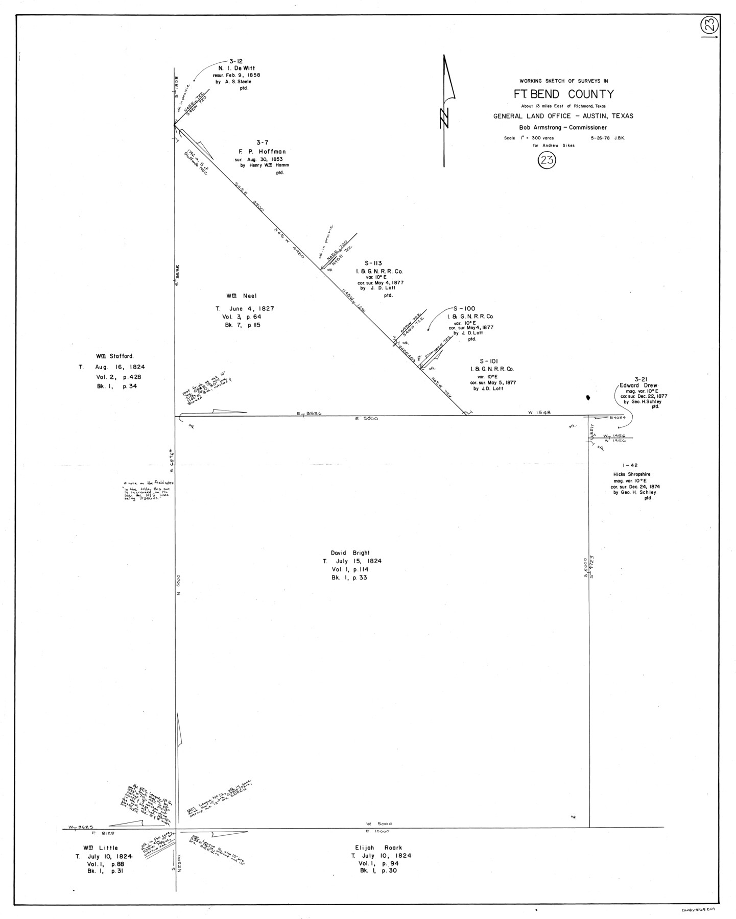
Fort Bend County Working Sketch 23
-
Map/Doc
69229
-
Collection
General Map Collection
-
Object Dates
5/26/1978 (Creation Date)
-
People and Organizations
Joan Kilpatrick (Draftsman)
-
Counties
Fort Bend
-
Subjects
Surveying Working Sketch
-
Height x Width
37.2 x 29.8 inches
94.5 x 75.7 cm
-
Scale
1" = 300 varas
Part of: General Map Collection
Uvalde County Working Sketch 9

Print $20.00
- Digital $50.00
Uvalde County Working Sketch 9
1942
Size 18.3 x 24.4 inches
Map/Doc 72079
McMullen County Sketch File 17

Print $4.00
- Digital $50.00
McMullen County Sketch File 17
Size 8.0 x 10.0 inches
Map/Doc 31369
Flight Mission No. CGI-3N, Frame 70, Cameron County

Print $20.00
- Digital $50.00
Flight Mission No. CGI-3N, Frame 70, Cameron County
1954
Size 18.7 x 22.3 inches
Map/Doc 84564
Panola County Working Sketch 11

Print $20.00
- Digital $50.00
Panola County Working Sketch 11
1944
Map/Doc 71420
Gaines County Working Sketch 31

Print $20.00
- Digital $50.00
Gaines County Working Sketch 31
1990
Size 37.4 x 26.8 inches
Map/Doc 69331
Hays County Sketch File C

Print $40.00
- Digital $50.00
Hays County Sketch File C
Size 17.9 x 14.6 inches
Map/Doc 26197
Newton County Rolled Sketch 15

Print $20.00
- Digital $50.00
Newton County Rolled Sketch 15
1953
Size 26.0 x 43.7 inches
Map/Doc 6845
Flight Mission No. DAG-21K, Frame 43, Matagorda County

Print $20.00
- Digital $50.00
Flight Mission No. DAG-21K, Frame 43, Matagorda County
1952
Size 18.9 x 22.6 inches
Map/Doc 86410
Stephens County Working Sketch 33

Print $20.00
- Digital $50.00
Stephens County Working Sketch 33
1978
Size 31.1 x 30.8 inches
Map/Doc 63976
Armstrong County Sketch File A-6

Print $40.00
- Digital $50.00
Armstrong County Sketch File A-6
1919
Size 18.3 x 15.8 inches
Map/Doc 10847
Hall County Sketch File C2

Print $6.00
- Digital $50.00
Hall County Sketch File C2
1905
Size 14.4 x 9.0 inches
Map/Doc 24789

You may also like
Plat of Location and Right of Way from El Paso, Tex. To New Mexico Line, Rio Grande and El Paso R. R.

Print $40.00
- Digital $50.00
Plat of Location and Right of Way from El Paso, Tex. To New Mexico Line, Rio Grande and El Paso R. R.
Size 22.5 x 121.3 inches
Map/Doc 64083
Moore County Rolled Sketch 13

Print $20.00
- Digital $50.00
Moore County Rolled Sketch 13
1920
Size 25.8 x 33.3 inches
Map/Doc 6829
Presidio County Rolled Sketch 140

Print $20.00
- Digital $50.00
Presidio County Rolled Sketch 140
2003
Size 44.4 x 34.7 inches
Map/Doc 78654
Aransas County Rolled Sketch 31A

Print $20.00
- Digital $50.00
Aransas County Rolled Sketch 31A
1950
Size 25.1 x 42.4 inches
Map/Doc 77499

Hudspeth County Sketch File 8

Print $20.00
- Digital $50.00
Hudspeth County Sketch File 8
1886
Size 40.7 x 43.3 inches
Map/Doc 10493
Subdivision of Sutton County School League 175. Bailey County, Texas

Print $2.00
- Digital $50.00
Subdivision of Sutton County School League 175. Bailey County, Texas
1929
Size 9.1 x 11.5 inches
Map/Doc 90278
Right of Way and Track Map, The Wichita Falls & Southern Railway

Print $40.00
- Digital $50.00
Right of Way and Track Map, The Wichita Falls & Southern Railway
1942
Size 25.0 x 121.0 inches
Map/Doc 64512
Val Verde County Working Sketch 96

Print $20.00
- Digital $50.00
Val Verde County Working Sketch 96
1979
Size 38.9 x 36.9 inches
Map/Doc 72231
Jefferson County Working Sketch 34

Print $20.00
- Digital $50.00
Jefferson County Working Sketch 34
1981
Size 33.4 x 18.8 inches
Map/Doc 66578
Williamson County Rolled Sketch 8

Print $20.00
- Digital $50.00
Williamson County Rolled Sketch 8
Size 15.1 x 18.0 inches
Map/Doc 8265
Duval County Rolled Sketch 41

Print $20.00
- Digital $50.00
Duval County Rolled Sketch 41
1966
Size 23.3 x 21.1 inches
Map/Doc 5758