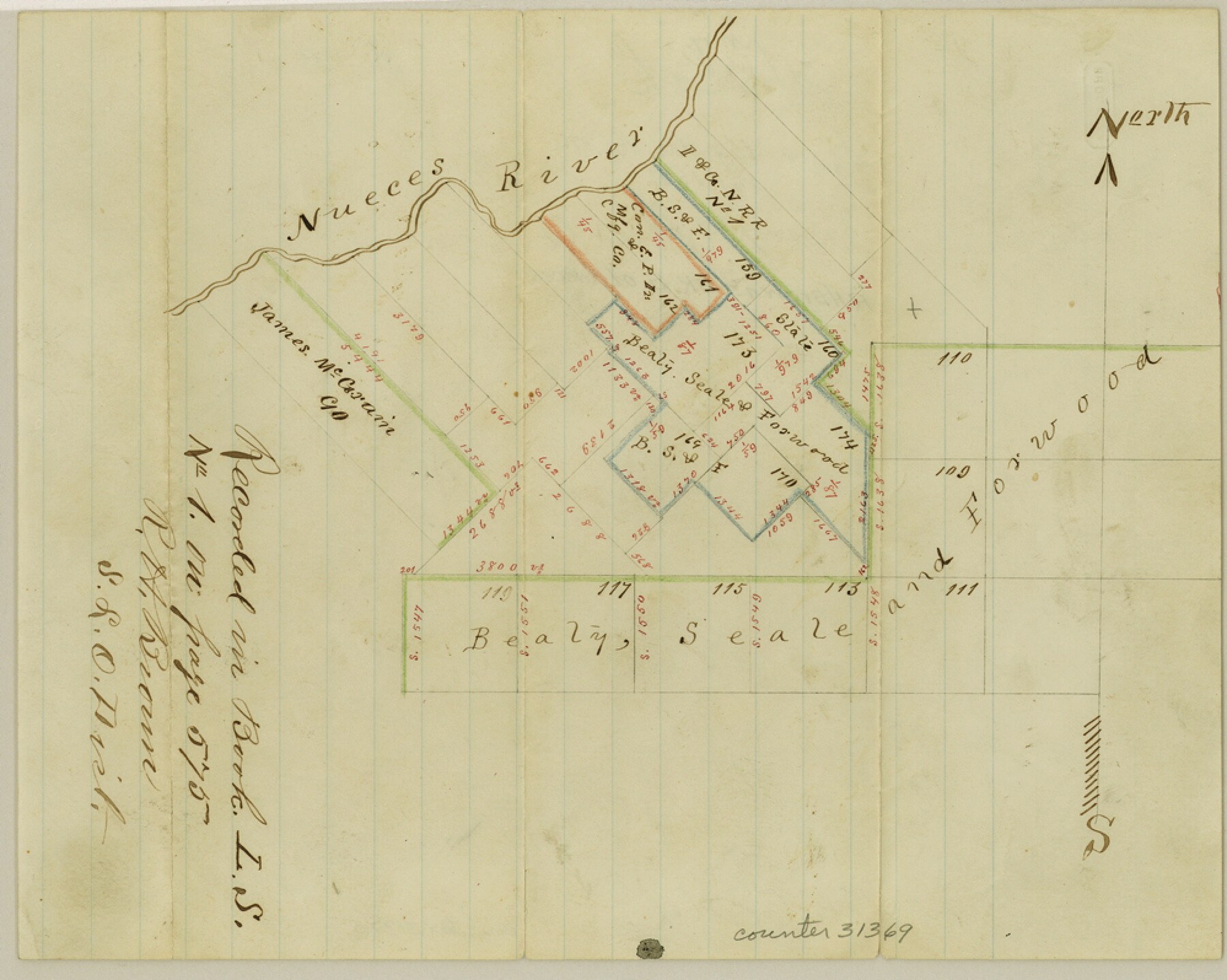
McMullen County Sketch File 17
[Sketch of surveys south of the Nueces River]
-
Map/Doc
31369
-
Collection
General Map Collection
-
People and Organizations
R.H. Brown (Surveyor/Engineer)
-
Counties
McMullen
-
Subjects
Surveying Sketch File
-
Height x Width
8.0 x 10.0 inches
20.3 x 25.4 cm
-
Medium
paper, manuscript
-
Features
Nueces River
Part of: General Map Collection
Flight Mission No. DIX-8P, Frame 91, Aransas County

Print $20.00
- Digital $50.00
Flight Mission No. DIX-8P, Frame 91, Aransas County
1956
Size 18.5 x 22.4 inches
Map/Doc 83916
Reagan County Sketch File 17

Print $40.00
- Digital $50.00
Reagan County Sketch File 17
Size 11.8 x 14.2 inches
Map/Doc 35006
Outer Continental Shelf Leasing Maps (Louisiana Offshore Operations)

Print $20.00
- Digital $50.00
Outer Continental Shelf Leasing Maps (Louisiana Offshore Operations)
1955
Size 15.9 x 10.8 inches
Map/Doc 76082
Flight Mission No. CON-4R, Frame 143, Stonewall County

Print $20.00
- Digital $50.00
Flight Mission No. CON-4R, Frame 143, Stonewall County
1957
Size 18.3 x 22.0 inches
Map/Doc 86993
Val Verde County Sketch File Z9

Print $20.00
- Digital $50.00
Val Verde County Sketch File Z9
1891
Size 15.9 x 24.8 inches
Map/Doc 12554
Duval County Sketch File 42

Print $4.00
- Digital $50.00
Duval County Sketch File 42
1936
Size 14.4 x 8.8 inches
Map/Doc 21394
Milam County Boundary File 2a

Print $10.00
- Digital $50.00
Milam County Boundary File 2a
Size 10.6 x 8.0 inches
Map/Doc 57208
Nueces County Sketch File 76

Print $54.00
- Digital $50.00
Nueces County Sketch File 76
1992
Size 11.0 x 8.6 inches
Map/Doc 33032
Stonewall County Working Sketch 10

Print $20.00
- Digital $50.00
Stonewall County Working Sketch 10
1950
Size 16.8 x 22.8 inches
Map/Doc 62317
Gray County Working Sketch 8

Print $20.00
- Digital $50.00
Gray County Working Sketch 8
1983
Size 18.3 x 22.8 inches
Map/Doc 63239

Tom Green County Rolled Sketch 24

Print $20.00
- Digital $50.00
Tom Green County Rolled Sketch 24
Size 14.4 x 19.1 inches
Map/Doc 8006
You may also like
Tarrant County Sketch File 2

Print $4.00
- Digital $50.00
Tarrant County Sketch File 2
1857
Size 7.0 x 6.5 inches
Map/Doc 37674
Flight Mission No. DAG-21K, Frame 108, Matagorda County

Print $20.00
- Digital $50.00
Flight Mission No. DAG-21K, Frame 108, Matagorda County
1952
Size 18.7 x 22.3 inches
Map/Doc 86436
Harris County Sketch File 59a

Print $20.00
- Digital $50.00
Harris County Sketch File 59a
Size 25.1 x 40.1 inches
Map/Doc 10479
Red River County Sketch File 1

Print $4.00
- Digital $50.00
Red River County Sketch File 1
Size 8.4 x 12.8 inches
Map/Doc 35091
University Lands as resurveyed by Frank F. Friend, Special Surveyor, San Angelo, Texas projected on a map of the State of Texas

Print $40.00
- Digital $50.00
University Lands as resurveyed by Frank F. Friend, Special Surveyor, San Angelo, Texas projected on a map of the State of Texas
1936
Size 31.0 x 55.8 inches
Map/Doc 2418
Cameron County Boundary File 2

Print $60.00
- Digital $50.00
Cameron County Boundary File 2
Size 47.8 x 22.1 inches
Map/Doc 51095
Floyd County Sketch File 1

Print $5.00
- Digital $50.00
Floyd County Sketch File 1
Size 11.0 x 17.0 inches
Map/Doc 22688
Newton County Sketch File 24

Print $4.00
- Digital $50.00
Newton County Sketch File 24
1881
Size 8.4 x 8.1 inches
Map/Doc 32405

[Scurry and Zavala County School Lands, and Blocks X, D, K, D-14, D-11, and E]
![91201, [Scurry and Zavala County School Lands, and Blocks X, D, K, D-14, D-11, and E], Twichell Survey Records](https://historictexasmaps.com/wmedia_w700/maps/91201-1.tif.jpg)
Print $20.00
- Digital $50.00
[Scurry and Zavala County School Lands, and Blocks X, D, K, D-14, D-11, and E]
Size 43.7 x 37.2 inches
Map/Doc 91201
Lubbock County Boundary File 2

Print $6.00
- Digital $50.00
Lubbock County Boundary File 2
Size 11.2 x 8.8 inches
Map/Doc 56488
[Leagues 7, 8, 9, and 10]
![92218, [Leagues 7, 8, 9, and 10], Twichell Survey Records](https://historictexasmaps.com/wmedia_w700/maps/92218-1.tif.jpg)
Print $20.00
- Digital $50.00
[Leagues 7, 8, 9, and 10]
1943
Size 20.0 x 13.4 inches
Map/Doc 92218