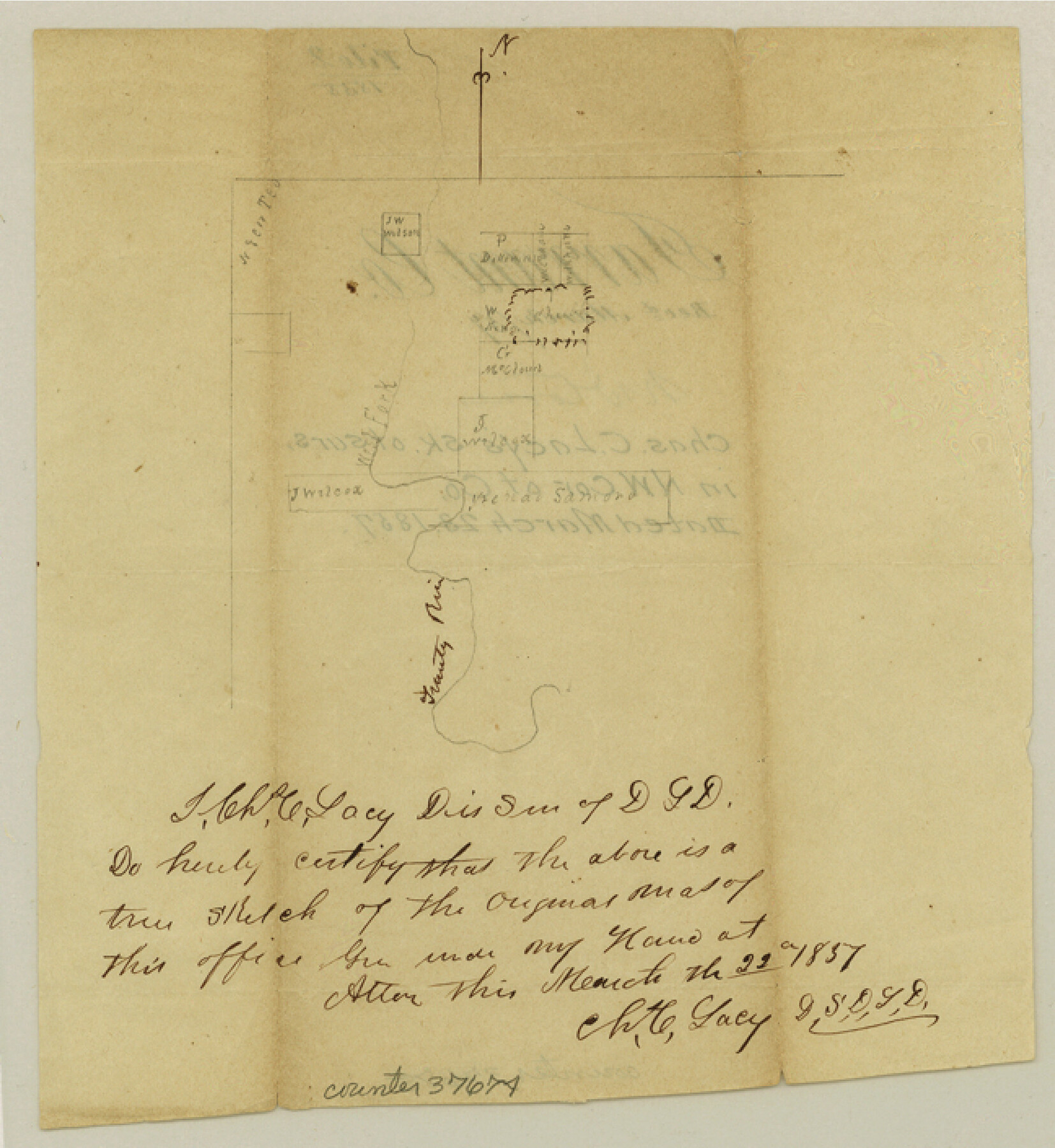
Tarrant County Sketch File 2
[Sketch of surveys in the northwest corner of the county]
-
Map/Doc
37674
-
Collection
General Map Collection
-
Object Dates
3/22/1857 (Creation Date)
-
People and Organizations
Charles C. Lacy (Surveyor/Engineer)
-
Counties
Tarrant
-
Subjects
Surveying Sketch File
-
Height x Width
7.0 x 6.5 inches
17.8 x 16.5 cm
-
Medium
paper, manuscript
-
Features
Trinity River
Part of: General Map Collection
Flight Mission No. DQN-7K, Frame 12, Calhoun County

Print $20.00
- Digital $50.00
Flight Mission No. DQN-7K, Frame 12, Calhoun County
1953
Size 18.6 x 22.2 inches
Map/Doc 84463
Johnson County Rolled Sketch 1

Print $20.00
- Digital $50.00
Johnson County Rolled Sketch 1
1941
Size 19.4 x 33.4 inches
Map/Doc 6446
Fort Bend County Working Sketch 17

Print $20.00
- Digital $50.00
Fort Bend County Working Sketch 17
1955
Size 25.1 x 31.1 inches
Map/Doc 69223
Menard County Sketch File 31

Print $4.00
- Digital $50.00
Menard County Sketch File 31
1978
Size 14.2 x 8.7 inches
Map/Doc 31573
Presidio County Sketch File 3

Print $6.00
- Digital $50.00
Presidio County Sketch File 3
1941
Size 8.5 x 7.7 inches
Map/Doc 34423
Matagorda County Rolled Sketch 25

Print $115.00
- Digital $50.00
Matagorda County Rolled Sketch 25
Size 9.7 x 15.0 inches
Map/Doc 46624
Grimes County Working Sketch 12

Print $20.00
- Digital $50.00
Grimes County Working Sketch 12
1982
Size 18.3 x 21.6 inches
Map/Doc 63303
Flight Mission No. BRA-8M, Frame 74, Jefferson County

Print $20.00
- Digital $50.00
Flight Mission No. BRA-8M, Frame 74, Jefferson County
1953
Size 18.6 x 22.2 inches
Map/Doc 85594
Land Grant Map of Comal County

Print $20.00
- Digital $50.00
Land Grant Map of Comal County
2006
Size 33.3 x 41.0 inches
Map/Doc 83601
Mills County Sketch File 22

Print $4.00
- Digital $50.00
Mills County Sketch File 22
1882
Size 9.8 x 8.0 inches
Map/Doc 31670
Hardeman County Boundary File 3b

Print $12.00
- Digital $50.00
Hardeman County Boundary File 3b
Size 14.1 x 8.7 inches
Map/Doc 54386
The south west and N.E. lines of Mary Thomas and A. Morrallis surveys

Print $2.00
- Digital $50.00
The south west and N.E. lines of Mary Thomas and A. Morrallis surveys
1847
Size 9.4 x 8.1 inches
Map/Doc 336
You may also like
[Blocks 44 and 6T]
![91410, [Blocks 44 and 6T], Twichell Survey Records](https://historictexasmaps.com/wmedia_w700/maps/91410-1.tif.jpg)
Print $20.00
- Digital $50.00
[Blocks 44 and 6T]
Size 29.3 x 17.4 inches
Map/Doc 91410
Leon County Working Sketch 42

Print $40.00
- Digital $50.00
Leon County Working Sketch 42
1980
Size 56.8 x 42.8 inches
Map/Doc 70441
Roberts County Boundary File 2b

Print $38.00
- Digital $50.00
Roberts County Boundary File 2b
Size 9.0 x 7.0 inches
Map/Doc 58344
[Sketch for Mineral Application 24072, San Jacinto River]
![65608, [Sketch for Mineral Application 24072, San Jacinto River], General Map Collection](https://historictexasmaps.com/wmedia_w700/maps/65608.tif.jpg)
Print $20.00
- Digital $50.00
[Sketch for Mineral Application 24072, San Jacinto River]
1929
Size 8.6 x 14.0 inches
Map/Doc 65608
Houston County Sketch File 6a

Print $4.00
- Digital $50.00
Houston County Sketch File 6a
Size 10.2 x 8.1 inches
Map/Doc 26762
Map of Runnels County

Print $20.00
- Digital $50.00
Map of Runnels County
1858
Size 24.7 x 25.6 inches
Map/Doc 4004

Flight Mission No. DQN-2K, Frame 136, Calhoun County

Print $20.00
- Digital $50.00
Flight Mission No. DQN-2K, Frame 136, Calhoun County
1953
Size 18.5 x 15.8 inches
Map/Doc 84305
Knox County Sketch File 7

Print $40.00
- Digital $50.00
Knox County Sketch File 7
1885
Size 32.2 x 19.9 inches
Map/Doc 11955
Hamilton County Working Sketch 10

Print $20.00
- Digital $50.00
Hamilton County Working Sketch 10
1946
Size 30.6 x 24.6 inches
Map/Doc 63348
Lebanon Quadrangle

Print $20.00
- Digital $50.00
Lebanon Quadrangle
1999
Size 35.4 x 23.4 inches
Map/Doc 97360
Culberson County Rolled Sketch 31

Print $20.00
- Digital $50.00
Culberson County Rolled Sketch 31
Size 44.1 x 34.4 inches
Map/Doc 8747