Menard County Sketch File 31
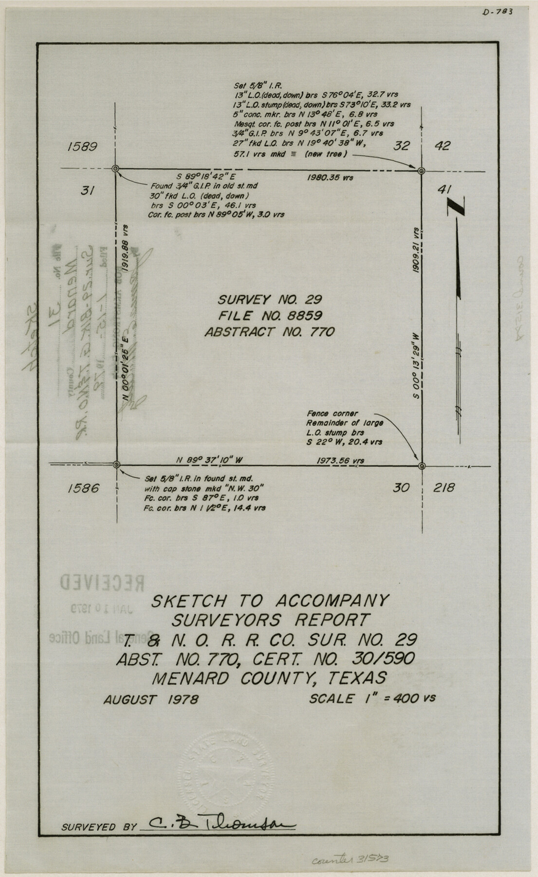
[Sketch of survey 29, Block 6, T. & N. O. RR. Co.]
-
Map/Doc
31573
-
Collection
General Map Collection
-
Object Dates
8/1978 (Creation Date)
1/15/1979 (File Date)
8/1978 (Survey Date)
-
People and Organizations
C.B. Thomson (Surveyor/Engineer)
-
Counties
Menard
-
Subjects
Surveying Sketch File
-
Height x Width
14.2 x 8.7 inches
36.1 x 22.1 cm
-
Medium
paper, manuscript
-
Scale
1:400
Part of: General Map Collection
Flight Mission No. CRC-2R, Frame 3, Chambers County

Print $20.00
- Digital $50.00
Flight Mission No. CRC-2R, Frame 3, Chambers County
1956
Size 18.8 x 22.5 inches
Map/Doc 84722
Travis County Sketch File 48

Print $6.00
- Digital $50.00
Travis County Sketch File 48
1940
Size 11.4 x 8.8 inches
Map/Doc 38377
Grayson County Rolled Sketch 2

Print $20.00
- Digital $50.00
Grayson County Rolled Sketch 2
1951
Size 25.5 x 42.5 inches
Map/Doc 6030
Briscoe County Working Sketch 5

Print $20.00
- Digital $50.00
Briscoe County Working Sketch 5
1934
Size 36.7 x 43.0 inches
Map/Doc 67808
Lee County Boundary File 2

Print $25.00
- Digital $50.00
Lee County Boundary File 2
Size 14.2 x 8.6 inches
Map/Doc 56269
Galveston County Sketch File 70

Print $26.00
- Digital $50.00
Galveston County Sketch File 70
1983
Size 11.3 x 8.7 inches
Map/Doc 23928
Webb County Rolled Sketch 54

Print $20.00
- Digital $50.00
Webb County Rolled Sketch 54
1935
Size 24.7 x 18.8 inches
Map/Doc 8206
Pecos County Sketch File 28a

Print $14.00
- Digital $50.00
Pecos County Sketch File 28a
1911
Size 14.5 x 8.9 inches
Map/Doc 33683
Travis County Rolled Sketch 60

Print $20.00
- Digital $50.00
Travis County Rolled Sketch 60
2014
Size 41.5 x 30.7 inches
Map/Doc 93723
Montgomery County Working Sketch 38

Print $20.00
- Digital $50.00
Montgomery County Working Sketch 38
1954
Size 23.6 x 28.5 inches
Map/Doc 71145
Eastland County Working Sketch 60a

Print $20.00
- Digital $50.00
Eastland County Working Sketch 60a
1988
Size 45.1 x 39.0 inches
Map/Doc 78209
Terrell County Rolled Sketch 50

Print $20.00
- Digital $50.00
Terrell County Rolled Sketch 50
1963
Size 35.9 x 20.5 inches
Map/Doc 7967
You may also like
Newton County Rolled Sketch 11

Print $20.00
- Digital $50.00
Newton County Rolled Sketch 11
1951
Size 15.5 x 46.1 inches
Map/Doc 9576
Gray County, Texas

Print $20.00
- Digital $50.00
Gray County, Texas
1889
Size 23.7 x 17.4 inches
Map/Doc 630
San Saba County Sketch File 13

Print $20.00
- Digital $50.00
San Saba County Sketch File 13
1890
Size 20.9 x 19.2 inches
Map/Doc 12291
Bowie County Sketch File 8d

Print $4.00
- Digital $50.00
Bowie County Sketch File 8d
Size 14.2 x 8.6 inches
Map/Doc 14894
Coke County Working Sketch 19

Print $20.00
- Digital $50.00
Coke County Working Sketch 19
1948
Size 22.2 x 29.0 inches
Map/Doc 68056
Jasper County Working Sketch 9

Print $20.00
- Digital $50.00
Jasper County Working Sketch 9
1917
Size 21.0 x 14.3 inches
Map/Doc 66471
The University of Texas at Austin

The University of Texas at Austin
Size 16.0 x 17.1 inches
Map/Doc 94388

Lampasas County Sketch File 22

Print $2.00
- Digital $50.00
Lampasas County Sketch File 22
2007
Size 14.0 x 8.5 inches
Map/Doc 93653
[BIock D13, north part H. & G. N. Block 2]
![90378, [BIock D13, north part H. & G. N. Block 2], Twichell Survey Records](https://historictexasmaps.com/wmedia_w700/maps/90378-1.tif.jpg)
Print $20.00
- Digital $50.00
[BIock D13, north part H. & G. N. Block 2]
Size 14.9 x 20.5 inches
Map/Doc 90378
Culberson County Working Sketch 44

Print $40.00
- Digital $50.00
Culberson County Working Sketch 44
1970
Size 53.4 x 36.4 inches
Map/Doc 68498
Brazos Santiago, Texas

Print $20.00
- Digital $50.00
Brazos Santiago, Texas
1882
Size 9.0 x 16.9 inches
Map/Doc 97186