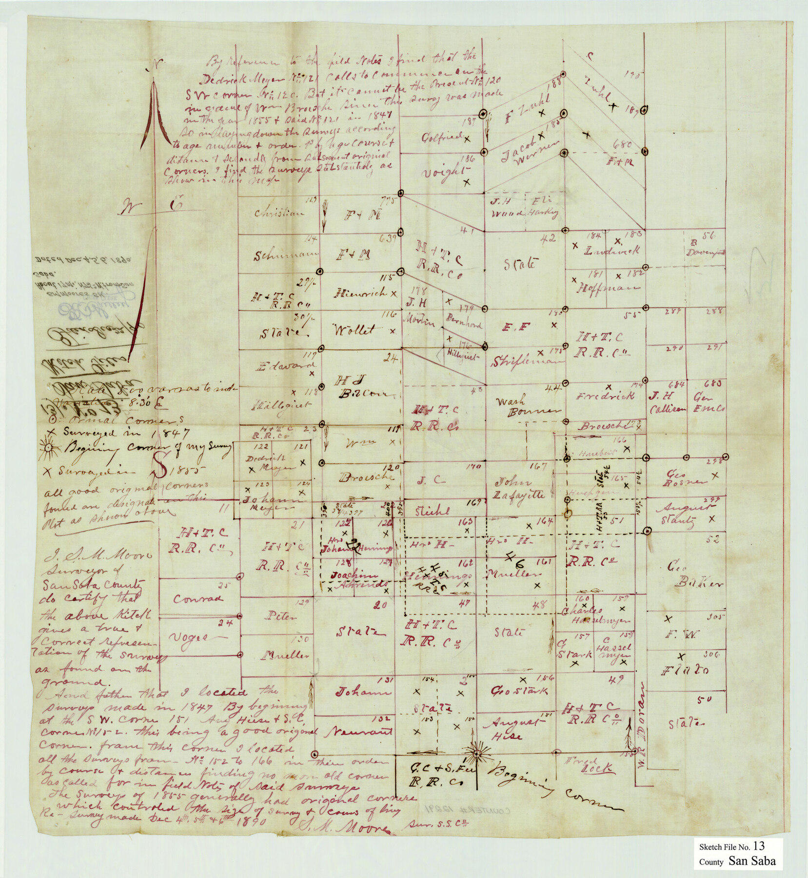
San Saba County Sketch File 13
[Sketch of surveys in western San Saba County in area surrounding H. & T. C. survey no. 42]
-
Map/Doc
12291
-
Collection
General Map Collection
-
Object Dates
12/6/1890 (Creation Date)
12/22/1890 (File Date)
-
People and Organizations
S.M. Moore (Surveyor/Engineer)
-
Counties
San Saba
-
Subjects
Surveying Sketch File
-
Height x Width
20.9 x 19.2 inches
53.1 x 48.8 cm
-
Medium
paper, manuscript
Part of: General Map Collection
Medina County Rolled Sketch 8

Print $20.00
- Digital $50.00
Medina County Rolled Sketch 8
1975
Size 24.8 x 25.5 inches
Map/Doc 6742
Travis County Rolled Sketch 27

Print $20.00
- Digital $50.00
Travis County Rolled Sketch 27
1945
Size 23.5 x 17.8 inches
Map/Doc 8029
Flight Mission No. CLL-3N, Frame 42, Willacy County

Print $20.00
- Digital $50.00
Flight Mission No. CLL-3N, Frame 42, Willacy County
1954
Size 18.5 x 22.1 inches
Map/Doc 87100

Flight Mission No. BQR-9K, Frame 8, Brazoria County

Print $20.00
- Digital $50.00
Flight Mission No. BQR-9K, Frame 8, Brazoria County
1952
Size 18.6 x 22.4 inches
Map/Doc 84037
Hood County Sketch File 27

Print $4.00
- Digital $50.00
Hood County Sketch File 27
1873
Size 12.9 x 8.5 inches
Map/Doc 26629
Travis County Appraisal District Plat Map 3_1100

Print $20.00
- Digital $50.00
Travis County Appraisal District Plat Map 3_1100
Size 21.5 x 26.4 inches
Map/Doc 94212
Dickens County Sketch File D

Print $20.00
- Digital $50.00
Dickens County Sketch File D
1883
Size 15.7 x 14.8 inches
Map/Doc 11330
Map of the Connection of S. C. Robertson's Survey

Print $3.00
- Digital $50.00
Map of the Connection of S. C. Robertson's Survey
1846
Size 10.5 x 16.0 inches
Map/Doc 334
Clay County Sketch File 41

Print $6.00
- Digital $50.00
Clay County Sketch File 41
1949
Size 14.2 x 8.6 inches
Map/Doc 18482
[Lower Part of Milam District]
![1961, [Lower Part of Milam District], General Map Collection](https://historictexasmaps.com/wmedia_w700/maps/1961.tif.jpg)
Print $20.00
- Digital $50.00
[Lower Part of Milam District]
1850
Size 46.5 x 44.2 inches
Map/Doc 1961
Hamilton County Sketch File 7

Print $40.00
- Digital $50.00
Hamilton County Sketch File 7
1860
Size 12.2 x 15.3 inches
Map/Doc 24912
You may also like
Hudspeth County Rolled Sketch 28

Print $40.00
- Digital $50.00
Hudspeth County Rolled Sketch 28
Size 31.5 x 49.8 inches
Map/Doc 9208
Railroad Track Map, H&TCRRCo., Falls County, Texas

Print $4.00
- Digital $50.00
Railroad Track Map, H&TCRRCo., Falls County, Texas
1918
Size 11.7 x 18.4 inches
Map/Doc 62862
Nueces County Sketch File 8

Print $22.00
- Digital $50.00
Nueces County Sketch File 8
1849
Size 8.2 x 12.4 inches
Map/Doc 32512
[Blocks CD, OP and GH in Crockett, Schleicher & Sutton Counties, Texas]
![75776, [Blocks CD, OP and GH in Crockett, Schleicher & Sutton Counties, Texas], Maddox Collection](https://historictexasmaps.com/wmedia_w700/maps/75776.tif.jpg)
Print $20.00
- Digital $50.00
[Blocks CD, OP and GH in Crockett, Schleicher & Sutton Counties, Texas]
Size 22.5 x 27.5 inches
Map/Doc 75776
Eastland County Sketch File 9

Print $4.00
- Digital $50.00
Eastland County Sketch File 9
Size 10.5 x 8.2 inches
Map/Doc 21580
Trinity River, Levee Improvements, District Widths of Floodways

Print $20.00
- Digital $50.00
Trinity River, Levee Improvements, District Widths of Floodways
1920
Size 25.0 x 18.6 inches
Map/Doc 65252
Clay County Boundary File 1

Print $10.00
- Digital $50.00
Clay County Boundary File 1
Size 8.8 x 11.2 inches
Map/Doc 51356
Texas and part of Mexico and the United States showing the Route of the First Santa Fe Expedition

Print $20.00
Texas and part of Mexico and the United States showing the Route of the First Santa Fe Expedition
1844
Size 20.3 x 15.8 inches
Map/Doc 79730
Liberty County Sketch File 64

Print $4.00
- Digital $50.00
Liberty County Sketch File 64
1873
Size 9.9 x 7.9 inches
Map/Doc 30126
Flight Mission No. DQN-5K, Frame 52, Calhoun County

Print $20.00
- Digital $50.00
Flight Mission No. DQN-5K, Frame 52, Calhoun County
1953
Size 18.6 x 22.3 inches
Map/Doc 84397
Interpretative map of wind erodibility. Gaines County, Texas

Interpretative map of wind erodibility. Gaines County, Texas
1986
Size 27.6 x 36.2 inches
Map/Doc 93561
Flight Mission No. DAG-21K, Frame 86, Matagorda County

Print $20.00
- Digital $50.00
Flight Mission No. DAG-21K, Frame 86, Matagorda County
1952
Size 18.5 x 19.5 inches
Map/Doc 86415