Hamilton County Sketch File 7
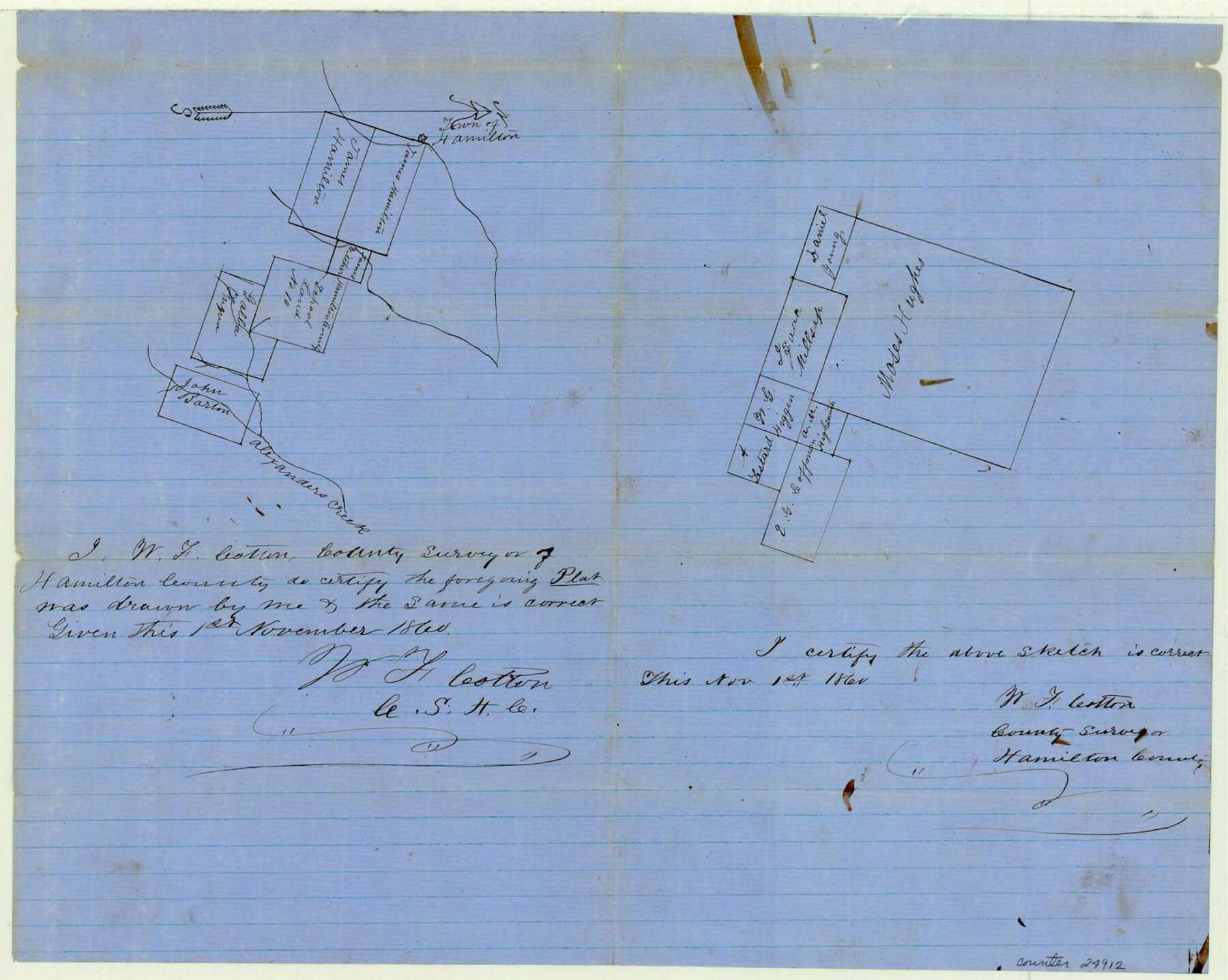
[Two sketches - one close but southeast of Hamilton, the other near the southern county line, west of Cowhouse Creek]
-
Map/Doc
24912
-
Collection
General Map Collection
-
Object Dates
1860/11/1 (Creation Date)
1860/11/20 (File Date)
-
People and Organizations
W.F. Cotton (Surveyor/Engineer)
-
Counties
Hamilton
-
Subjects
Surveying Sketch File
-
Height x Width
12.2 x 15.3 inches
31.0 x 38.9 cm
-
Medium
paper, manuscript
-
Features
Hamilton
Alexander's Creek
Cowhouse Creek
Part of: General Map Collection
Flight Mission No. CGI-4N, Frame 188, Cameron County

Print $20.00
- Digital $50.00
Flight Mission No. CGI-4N, Frame 188, Cameron County
1955
Size 18.5 x 22.3 inches
Map/Doc 84691
Tarrant County Working Sketch 14

Print $20.00
- Digital $50.00
Tarrant County Working Sketch 14
1989
Size 26.5 x 31.0 inches
Map/Doc 62431
Upton County Sketch File 32

Print $20.00
- Digital $50.00
Upton County Sketch File 32
1938
Size 14.9 x 24.0 inches
Map/Doc 12523
Castro County Sketch File 4k

Print $4.00
- Digital $50.00
Castro County Sketch File 4k
Size 13.6 x 8.6 inches
Map/Doc 17485
Rand, McNally and Co.'s Texas and Indian Territory

Print $20.00
- Digital $50.00
Rand, McNally and Co.'s Texas and Indian Territory
1883
Size 24.3 x 18.6 inches
Map/Doc 4331
Hudspeth County Sketch File 29

Print $20.00
- Digital $50.00
Hudspeth County Sketch File 29
1918
Size 22.3 x 21.4 inches
Map/Doc 11804
Flight Mission No. BQR-12K, Frame 51, Brazoria County

Print $20.00
- Digital $50.00
Flight Mission No. BQR-12K, Frame 51, Brazoria County
1952
Size 18.8 x 22.4 inches
Map/Doc 84066
Loving County Working Sketch 16

Print $40.00
- Digital $50.00
Loving County Working Sketch 16
1973
Size 33.3 x 54.1 inches
Map/Doc 70649

Tarrant County Boundary File 4 and 4a

Print $6.00
- Digital $50.00
Tarrant County Boundary File 4 and 4a
Size 11.5 x 9.0 inches
Map/Doc 59151
North Part Brewster Co.

Print $40.00
- Digital $50.00
North Part Brewster Co.
1914
Size 40.6 x 49.2 inches
Map/Doc 66729
Limestone County Working Sketch 8

Print $20.00
- Digital $50.00
Limestone County Working Sketch 8
1922
Size 30.6 x 18.4 inches
Map/Doc 70558
You may also like
Jasper County Rolled Sketch 4

Print $20.00
- Digital $50.00
Jasper County Rolled Sketch 4
1947
Size 40.0 x 31.1 inches
Map/Doc 6351
Flight Mission No. CRC-2R, Frame 197, Chambers County

Print $20.00
- Digital $50.00
Flight Mission No. CRC-2R, Frame 197, Chambers County
1956
Size 18.7 x 22.5 inches
Map/Doc 84775
Corpus Christi Harbor

Print $40.00
- Digital $50.00
Corpus Christi Harbor
1975
Size 37.6 x 51.5 inches
Map/Doc 73479
Refugio County Boundary File 1

Print $6.00
- Digital $50.00
Refugio County Boundary File 1
Size 8.1 x 3.4 inches
Map/Doc 58225
Harris County Historic Topographic 10

Print $20.00
- Digital $50.00
Harris County Historic Topographic 10
1916
Size 30.2 x 22.9 inches
Map/Doc 65820
Polk County Rolled Sketch 30

Print $20.00
- Digital $50.00
Polk County Rolled Sketch 30
1958
Size 27.8 x 31.5 inches
Map/Doc 7316

Culberson County Working Sketch 55

Print $20.00
- Digital $50.00
Culberson County Working Sketch 55
1974
Size 47.1 x 33.7 inches
Map/Doc 68509
Plat Showing Subdivision of Howard County School Land Hockley County, Texas

Print $20.00
- Digital $50.00
Plat Showing Subdivision of Howard County School Land Hockley County, Texas
1947
Size 13.9 x 28.1 inches
Map/Doc 92256
Lipscomb County Rolled Sketch 3

Print $20.00
- Digital $50.00
Lipscomb County Rolled Sketch 3
1886
Size 24.2 x 31.0 inches
Map/Doc 6629
Van Zandt County Sketch File 5

Print $22.00
- Digital $50.00
Van Zandt County Sketch File 5
Size 20.5 x 6.3 inches
Map/Doc 39371
Bandera County Working Sketch 42

Print $20.00
- Digital $50.00
Bandera County Working Sketch 42
1978
Size 26.9 x 29.8 inches
Map/Doc 67638