Castro County Sketch File 4k
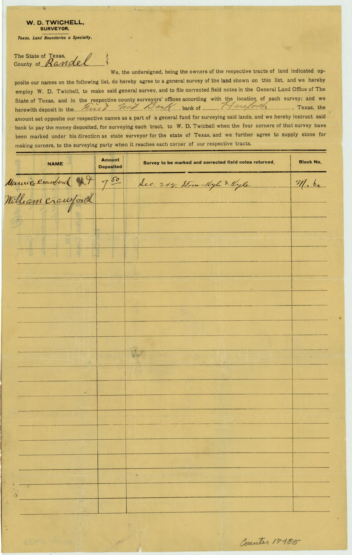
[Agreement for W.D. Twichell to survey section 242 in Block M6 in Randall County]
-
Map/Doc
17485
-
Collection
General Map Collection
-
People and Organizations
W.D. Twichell (Surveyor/Engineer)
-
Counties
Randall
-
Subjects
Surveying Sketch File
-
Height x Width
13.6 x 8.6 inches
34.5 x 21.8 cm
-
Medium
paper, print with manuscript additions
Part of: General Map Collection
Sutton County Working Sketch 62

Print $20.00
- Digital $50.00
Sutton County Working Sketch 62
1959
Size 31.3 x 38.1 inches
Map/Doc 62405
Flight Mission No. CGI-3N, Frame 110, Cameron County

Print $20.00
- Digital $50.00
Flight Mission No. CGI-3N, Frame 110, Cameron County
1954
Size 18.5 x 22.1 inches
Map/Doc 84590
Calhoun County Rolled Sketch 35

Print $20.00
- Digital $50.00
Calhoun County Rolled Sketch 35
1929
Size 36.5 x 26.6 inches
Map/Doc 5511
Current Miscellaneous File 28

Print $22.00
- Digital $50.00
Current Miscellaneous File 28
1952
Size 10.7 x 16.3 inches
Map/Doc 73911
[Atlas A, Table of Contents, part 1]
![78351, [Atlas A, Table of Contents, part 1], General Map Collection](https://historictexasmaps.com/wmedia_w700/maps/78351.tif.jpg)
Print $20.00
- Digital $50.00
[Atlas A, Table of Contents, part 1]
Size 14.5 x 15.0 inches
Map/Doc 78351
Flight Mission No. CRE-1R, Frame 63, Jackson County

Print $20.00
- Digital $50.00
Flight Mission No. CRE-1R, Frame 63, Jackson County
1956
Size 18.6 x 18.9 inches
Map/Doc 85326
Denton County Working Sketch 27

Print $20.00
- Digital $50.00
Denton County Working Sketch 27
1996
Size 41.3 x 35.3 inches
Map/Doc 68632
Red River County Working Sketch 72

Print $20.00
- Digital $50.00
Red River County Working Sketch 72
1979
Size 24.7 x 19.8 inches
Map/Doc 72055
Flight Mission No. CGI-3N, Frame 160, Cameron County

Print $20.00
- Digital $50.00
Flight Mission No. CGI-3N, Frame 160, Cameron County
1954
Size 18.5 x 22.3 inches
Map/Doc 84624
[Map of Block 97, Borden and Scurry Co (Exhibit A); Map of Southeastern part of Young Territory; Map of part of of Borden, Fisher, Kent, Mitchell, Scurry and Garza Cos. Showing the north boundary line of the T&P 80 mile reservation]
![65690, [Map of Block 97, Borden and Scurry Co (Exhibit A); Map of Southeastern part of Young Territory; Map of part of of Borden, Fisher, Kent, Mitchell, Scurry and Garza Cos. Showing the north boundary line of the T&P 80 mile reservation], General Map Collection](https://historictexasmaps.com/wmedia_w700/maps/65690-1.tif.jpg)
Print $40.00
- Digital $50.00
[Map of Block 97, Borden and Scurry Co (Exhibit A); Map of Southeastern part of Young Territory; Map of part of of Borden, Fisher, Kent, Mitchell, Scurry and Garza Cos. Showing the north boundary line of the T&P 80 mile reservation]
Size 58.7 x 42.4 inches
Map/Doc 65690
Flight Mission No. DAG-24K, Frame 140, Matagorda County

Print $20.00
- Digital $50.00
Flight Mission No. DAG-24K, Frame 140, Matagorda County
1953
Size 17.0 x 15.6 inches
Map/Doc 86558
Trinity County Rolled Sketch 6

Print $20.00
- Digital $50.00
Trinity County Rolled Sketch 6
1999
Size 25.0 x 19.3 inches
Map/Doc 8053
You may also like
General Highway Map, Haskell County, Texas

Print $20.00
General Highway Map, Haskell County, Texas
1940
Size 18.5 x 24.8 inches
Map/Doc 79122
Brooks County Working Sketch 18

Print $20.00
- Digital $50.00
Brooks County Working Sketch 18
1981
Size 20.6 x 32.4 inches
Map/Doc 67802
Flight Mission No. CGN-3P, Frame 21, San Patricio County

Print $20.00
- Digital $50.00
Flight Mission No. CGN-3P, Frame 21, San Patricio County
1956
Size 18.2 x 22.0 inches
Map/Doc 86979
Old Miscellaneous File 6

Print $4.00
- Digital $50.00
Old Miscellaneous File 6
1847
Size 4.2 x 7.6 inches
Map/Doc 75420
Colorado County Sketch File 27

Print $20.00
- Digital $50.00
Colorado County Sketch File 27
1911
Size 25.3 x 19.4 inches
Map/Doc 11138
Map of Abernathy Located on Section 12, Block CK, Hale and Lubbock Counties, Texas

Print $20.00
- Digital $50.00
Map of Abernathy Located on Section 12, Block CK, Hale and Lubbock Counties, Texas
Size 29.9 x 33.0 inches
Map/Doc 92666
Navarro County Sketch File 6

Print $6.00
- Digital $50.00
Navarro County Sketch File 6
1849
Size 6.2 x 8.4 inches
Map/Doc 32310
General Highway Map, Mason County, Texas

Print $20.00
General Highway Map, Mason County, Texas
1961
Size 18.3 x 24.8 inches
Map/Doc 79584
Harris County Working Sketch 67

Print $20.00
- Digital $50.00
Harris County Working Sketch 67
1955
Size 23.3 x 27.5 inches
Map/Doc 65959
Ellis County Working Sketch 3

Print $40.00
- Digital $50.00
Ellis County Working Sketch 3
1981
Size 39.1 x 50.0 inches
Map/Doc 69019
Amistad International Reservoir on Rio Grande 100

Print $20.00
- Digital $50.00
Amistad International Reservoir on Rio Grande 100
1950
Size 28.5 x 40.8 inches
Map/Doc 75531
Bastrop County

Print $20.00
- Digital $50.00
Bastrop County
1883
Size 25.9 x 25.2 inches
Map/Doc 3276