Upton County Sketch File 32
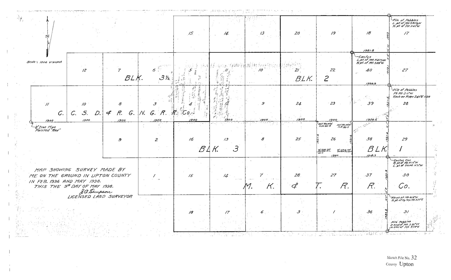
Map showing survey made by me on the ground in Upton County in Feb. 1936 and May 1938. J. A. Simpson.
-
Map/Doc
12523
-
Collection
General Map Collection
-
Object Dates
1938/5/9 (Creation Date)
1938/5/23 (File Date)
1938/5/9 (Creation Date)
1938 (Survey Date)
1938 (Survey Date)
-
People and Organizations
J.A. Simpson (Surveyor/Engineer)
-
Counties
Upton
-
Subjects
Surveying Sketch File
-
Height x Width
14.9 x 24.0 inches
37.8 x 61.0 cm
-
Medium
paper, print
Part of: General Map Collection
Schleicher County Sketch File 47

Print $4.00
- Digital $50.00
Schleicher County Sketch File 47
1953
Size 4.4 x 8.7 inches
Map/Doc 36556
Terrell County Sketch File 37

Print $4.00
- Digital $50.00
Terrell County Sketch File 37
Size 14.5 x 9.1 inches
Map/Doc 37999
Duval County Boundary File 3k

Print $40.00
- Digital $50.00
Duval County Boundary File 3k
Size 30.1 x 7.0 inches
Map/Doc 52759
Orange County Sketch File 11

Print $42.00
- Digital $50.00
Orange County Sketch File 11
1876
Size 12.8 x 16.5 inches
Map/Doc 33319
Fort Bend County Working Sketch 6

Print $20.00
- Digital $50.00
Fort Bend County Working Sketch 6
1917
Size 15.7 x 15.5 inches
Map/Doc 69212
Anderson County Working Sketch 18

Print $20.00
- Digital $50.00
Anderson County Working Sketch 18
1950
Size 19.9 x 21.2 inches
Map/Doc 67018
Anderson County Rolled Sketch 14

Print $20.00
- Digital $50.00
Anderson County Rolled Sketch 14
1997
Size 30.1 x 36.5 inches
Map/Doc 77159
Hudspeth County Sketch File 11a

Print $8.00
- Digital $50.00
Hudspeth County Sketch File 11a
Size 14.3 x 9.0 inches
Map/Doc 26910
Polk County Sketch File 11

Print $4.00
- Digital $50.00
Polk County Sketch File 11
Size 9.2 x 8.1 inches
Map/Doc 34142
Crockett County Working Sketch 78

Print $40.00
- Digital $50.00
Crockett County Working Sketch 78
1972
Size 48.3 x 36.0 inches
Map/Doc 68411
Chambers County Rolled Sketch 23

Print $40.00
- Digital $50.00
Chambers County Rolled Sketch 23
1940
Size 36.5 x 49.2 inches
Map/Doc 8591
Colorado County Sketch File 1

Print $40.00
- Digital $50.00
Colorado County Sketch File 1
1848
Size 13.0 x 16.1 inches
Map/Doc 18909
You may also like
Kerr County Boundary File 3

Print $6.00
- Digital $50.00
Kerr County Boundary File 3
Size 11.3 x 8.8 inches
Map/Doc 55998
Intracoastal Waterway in Texas - Corpus Christi to Point Isabel including Arroyo Colorado to Mo. Pac. R.R. Bridge Near Harlingen

Print $20.00
- Digital $50.00
Intracoastal Waterway in Texas - Corpus Christi to Point Isabel including Arroyo Colorado to Mo. Pac. R.R. Bridge Near Harlingen
1933
Size 28.0 x 41.0 inches
Map/Doc 61860
Kent County Working Sketch 21

Print $20.00
- Digital $50.00
Kent County Working Sketch 21
1981
Size 43.5 x 37.5 inches
Map/Doc 70028
Brewster County Working Sketch 75

Print $20.00
- Digital $50.00
Brewster County Working Sketch 75
1967
Size 28.3 x 36.9 inches
Map/Doc 67675
Wheeler County Working Sketch 20

Print $20.00
- Digital $50.00
Wheeler County Working Sketch 20
1989
Size 40.4 x 32.6 inches
Map/Doc 72509
Taylor County Sketch File 17

Print $40.00
- Digital $50.00
Taylor County Sketch File 17
Size 14.5 x 17.7 inches
Map/Doc 37811
Map of the River Sabine shewing that portion of the Boundary between the Republic of Texas and the United States included between Logan's Ferry and the Intersection of the 32nd degree of N. Latitude with the Western bank of Sabine River

Print $20.00
- Digital $50.00
Map of the River Sabine shewing that portion of the Boundary between the Republic of Texas and the United States included between Logan's Ferry and the Intersection of the 32nd degree of N. Latitude with the Western bank of Sabine River
1842
Size 19.2 x 27.3 inches
Map/Doc 65410
Flight Mission No. BRA-6M, Frame 81, Jefferson County

Print $20.00
- Digital $50.00
Flight Mission No. BRA-6M, Frame 81, Jefferson County
1953
Size 18.6 x 22.6 inches
Map/Doc 85425
Runnels County Rolled Sketch 49

Print $20.00
- Digital $50.00
Runnels County Rolled Sketch 49
Size 28.8 x 29.1 inches
Map/Doc 7534
Sabine County Working Sketch 9

Print $20.00
- Digital $50.00
Sabine County Working Sketch 9
1923
Size 23.9 x 27.1 inches
Map/Doc 63680
Gonzales County

Print $20.00
- Digital $50.00
Gonzales County
1853
Size 23.4 x 22.4 inches
Map/Doc 3591
General Highway Map, Trinity County, Texas

Print $20.00
General Highway Map, Trinity County, Texas
1961
Size 18.1 x 24.5 inches
Map/Doc 79688