Colorado County Sketch File 1
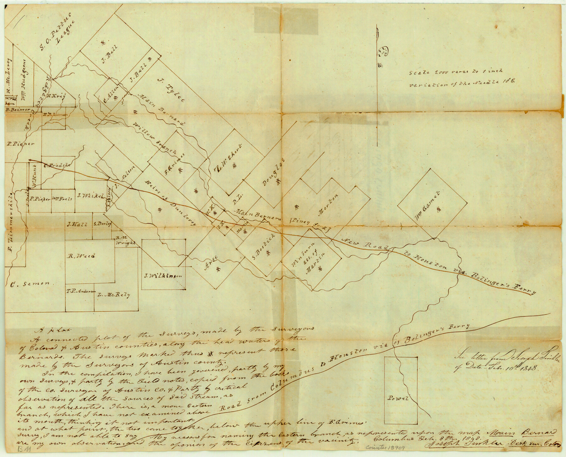
[Sketch of connections of surveys mad in Colorado and Austin Counties]
-
Map/Doc
18909
-
Collection
General Map Collection
-
Object Dates
3/10/1848 (File Date)
2/22/1848 (File Date)
2/8/1848 (Creation Date)
-
People and Organizations
Joseph Tinkler (Surveyor/Engineer)
-
Counties
Colorado Austin
-
Subjects
Surveying Sketch File
-
Height x Width
13.0 x 16.1 inches
33.0 x 40.9 cm
-
Medium
paper, manuscript
-
Scale
1" = 2000 varas
-
Comments
"See letter from Joseph Tinkler of date Feb. 10th, 1948"
-
Features
Main Bernard River
Willow Branch of Bernard River
Redgate's Creek
Main Branch (Piney Fork) of Bernard River
New Road to Houston via Bolinder's Ferry
Road from Columbus to Houston via of Bolinger's Ferry
Columbus Road
Houston Road
Part of: General Map Collection
Sherman County Boundary File 3

Print $55.00
- Digital $50.00
Sherman County Boundary File 3
Size 9.2 x 8.6 inches
Map/Doc 58773
Hardin County Sketch File 49

Print $4.00
- Digital $50.00
Hardin County Sketch File 49
1904
Size 14.5 x 8.8 inches
Map/Doc 25202
Nueces County Rolled Sketch 113B

Print $20.00
- Digital $50.00
Nueces County Rolled Sketch 113B
1972
Size 18.6 x 24.2 inches
Map/Doc 7123
Terry County Rolled Sketch 10

Print $20.00
- Digital $50.00
Terry County Rolled Sketch 10
2001
Size 25.2 x 23.8 inches
Map/Doc 76414
Galveston Bay from a Spanish M. S.

Print $20.00
- Digital $50.00
Galveston Bay from a Spanish M. S.
1846
Size 25.1 x 18.2 inches
Map/Doc 72759
Flight Mission No. DQO-8K, Frame 70, Galveston County

Print $20.00
- Digital $50.00
Flight Mission No. DQO-8K, Frame 70, Galveston County
1952
Size 18.7 x 22.3 inches
Map/Doc 85174
Instruccion Publica

Print $20.00
- Digital $50.00
Instruccion Publica
Size 26.0 x 34.2 inches
Map/Doc 96801

Matagorda County Rolled Sketch 28

Print $20.00
- Digital $50.00
Matagorda County Rolled Sketch 28
1945
Size 33.3 x 43.4 inches
Map/Doc 9481
Baylor County Boundary File 15

Print $4.00
- Digital $50.00
Baylor County Boundary File 15
Size 10.1 x 8.0 inches
Map/Doc 50431
Frio County Rolled Sketch 21

Print $20.00
- Digital $50.00
Frio County Rolled Sketch 21
1961
Size 43.8 x 27.7 inches
Map/Doc 8911
Cottle County Working Sketch 18

Print $20.00
- Digital $50.00
Cottle County Working Sketch 18
1977
Size 32.2 x 41.3 inches
Map/Doc 68328
You may also like
Red River County Working Sketch 31

Print $20.00
- Digital $50.00
Red River County Working Sketch 31
1962
Size 30.9 x 31.3 inches
Map/Doc 72014
Denton County Working Sketch 20

Print $20.00
- Digital $50.00
Denton County Working Sketch 20
1978
Size 31.6 x 33.2 inches
Map/Doc 68625
The Republic County of Fort Bend. February 5, 1840

Print $20.00
The Republic County of Fort Bend. February 5, 1840
2020
Size 14.7 x 21.6 inches
Map/Doc 96139

Trinity County Sketch File 24

Print $4.00
- Digital $50.00
Trinity County Sketch File 24
Size 7.5 x 10.5 inches
Map/Doc 38556
Texas Gulf Coast Map from the Sabine River to the Rio Grande as subdivided for mineral development

Print $40.00
- Digital $50.00
Texas Gulf Coast Map from the Sabine River to the Rio Grande as subdivided for mineral development
1966
Size 42.8 x 69.7 inches
Map/Doc 2497
English Field Notes of the Spanish Archives - Book 3

English Field Notes of the Spanish Archives - Book 3
1835
Map/Doc 96529
Terrell County Sketch File 19

Print $6.00
- Digital $50.00
Terrell County Sketch File 19
1910
Size 10.2 x 12.1 inches
Map/Doc 37944
From Citizens Living in Red River County for the Creation of a New County (Unnamed), Undated

Print $20.00
From Citizens Living in Red River County for the Creation of a New County (Unnamed), Undated
2020
Size 16.6 x 21.7 inches
Map/Doc 96405
Current Miscellaneous File 59

Print $16.00
- Digital $50.00
Current Miscellaneous File 59
1836
Size 11.4 x 8.9 inches
Map/Doc 74056
Reeves County

Print $40.00
- Digital $50.00
Reeves County
1945
Size 48.6 x 39.6 inches
Map/Doc 63001
Upton County Sketch File 25

Print $20.00
- Digital $50.00
Upton County Sketch File 25
1928
Size 27.1 x 44.4 inches
Map/Doc 10415