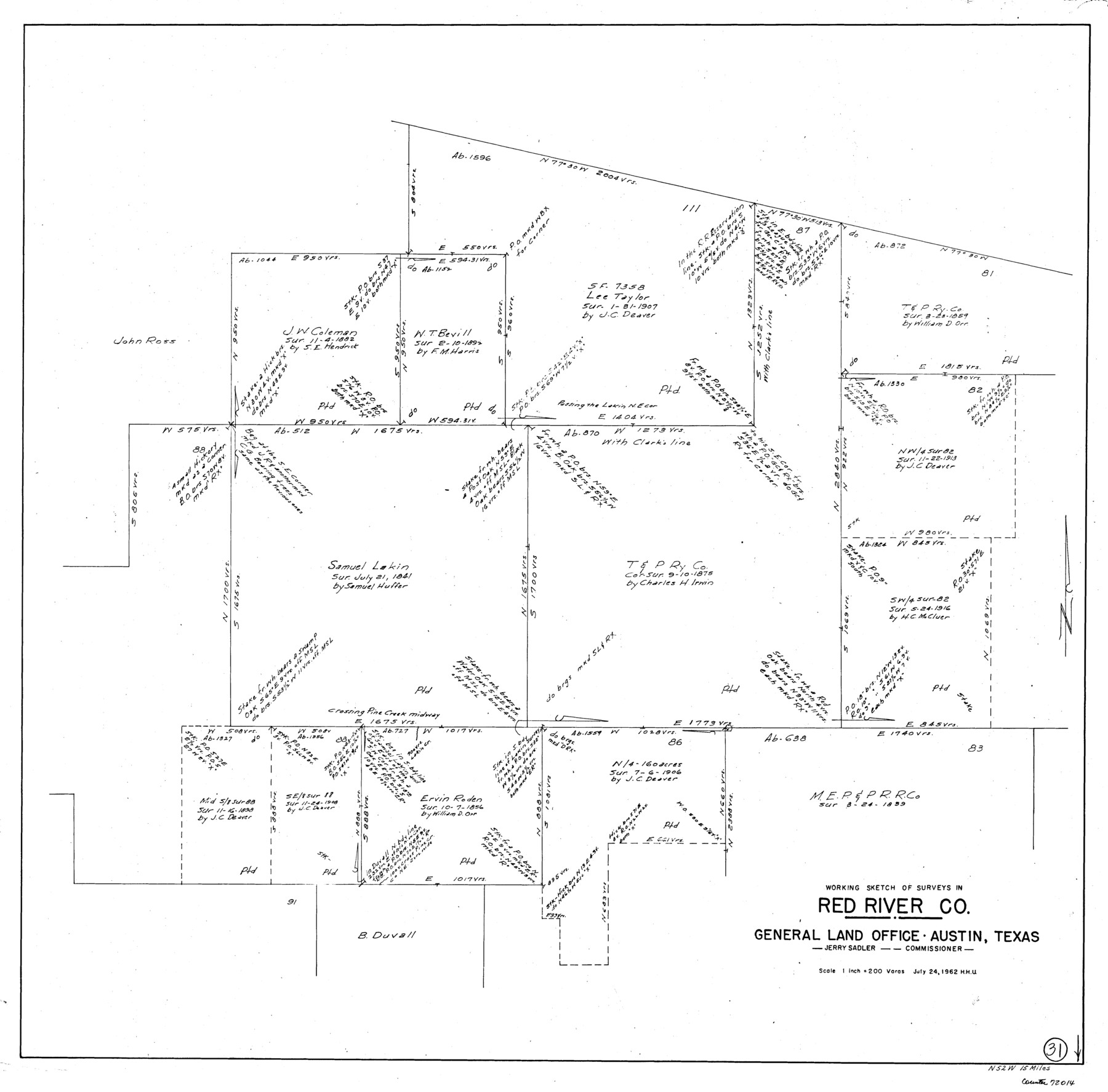
Red River County Working Sketch 31
-
Map/Doc
72014
-
Collection
General Map Collection
-
Object Dates
7/24/1962 (Creation Date)
-
People and Organizations
Herbert H. Ulbricht (Draftsman)
-
Counties
Red River
-
Subjects
Surveying Working Sketch
-
Height x Width
30.9 x 31.3 inches
78.5 x 79.5 cm
-
Scale
1" = 200 varas
Part of: General Map Collection

Panola County Working Sketch 24

Print $20.00
- Digital $50.00
Panola County Working Sketch 24
1957
Map/Doc 71433
Orange County Working Sketch 15

Print $20.00
- Digital $50.00
Orange County Working Sketch 15
1928
Size 19.3 x 24.6 inches
Map/Doc 71347
Franklin County Working Sketch Graphic Index

Print $20.00
- Digital $50.00
Franklin County Working Sketch Graphic Index
1942
Size 40.3 x 16.2 inches
Map/Doc 76546
Gregg County Sketch File 1F

Print $4.00
- Digital $50.00
Gregg County Sketch File 1F
1850
Size 12.2 x 7.8 inches
Map/Doc 24547
Angelina County Rolled Sketch 5

Print $40.00
- Digital $50.00
Angelina County Rolled Sketch 5
1993
Size 36.0 x 75.3 inches
Map/Doc 9328
Flight Mission No. BRA-7M, Frame 19, Jefferson County

Print $20.00
- Digital $50.00
Flight Mission No. BRA-7M, Frame 19, Jefferson County
1953
Size 18.8 x 22.4 inches
Map/Doc 85470
Titus County Boundary File 4

Print $18.00
- Digital $50.00
Titus County Boundary File 4
Size 9.3 x 7.8 inches
Map/Doc 59303
Culberson County Sketch File 42

Print $14.00
- Digital $50.00
Culberson County Sketch File 42
1966
Size 14.2 x 8.7 inches
Map/Doc 20322
Anderson County Sketch File 18

Print $40.00
- Digital $50.00
Anderson County Sketch File 18
1880
Size 16.0 x 13.5 inches
Map/Doc 10801
San Jacinto County Rolled Sketch 7

Print $20.00
- Digital $50.00
San Jacinto County Rolled Sketch 7
1940
Size 23.6 x 28.8 inches
Map/Doc 7558
Wise County Sketch File 20

Print $14.00
- Digital $50.00
Wise County Sketch File 20
1860
Size 12.8 x 7.9 inches
Map/Doc 40557
You may also like
Gonzales County Rolled Sketch 3

Print $20.00
- Digital $50.00
Gonzales County Rolled Sketch 3
2021
Size 24.4 x 35.6 inches
Map/Doc 96582
Harrison County Rolled Sketch 13

Print $20.00
- Digital $50.00
Harrison County Rolled Sketch 13
1967
Size 32.5 x 28.3 inches
Map/Doc 6156
Montgomery County Working Sketch 4

Print $20.00
- Digital $50.00
Montgomery County Working Sketch 4
1926
Size 20.9 x 22.2 inches
Map/Doc 71110
Cameron County Sketch File 12

Print $222.00
- Digital $50.00
Cameron County Sketch File 12
Size 10.8 x 7.4 inches
Map/Doc 17236
Upton County Working Sketch 32

Print $40.00
- Digital $50.00
Upton County Working Sketch 32
1956
Size 55.4 x 37.9 inches
Map/Doc 69528
Denton County Working Sketch 39

Print $20.00
- Digital $50.00
Denton County Working Sketch 39
2018
Size 24.2 x 35.4 inches
Map/Doc 95323
Leon County Rolled Sketch 20

Print $20.00
- Digital $50.00
Leon County Rolled Sketch 20
Size 27.0 x 25.8 inches
Map/Doc 6607
Grayson County Sketch File 18

Print $6.00
- Digital $50.00
Grayson County Sketch File 18
1859
Size 12.2 x 7.9 inches
Map/Doc 24487
Travis County

Print $40.00
- Digital $50.00
Travis County
1936
Size 45.6 x 52.3 inches
Map/Doc 77438
Preliminary Chart of the Northwestern Part of the Gulf of Mexico - Unfinished Proof

Print $40.00
Preliminary Chart of the Northwestern Part of the Gulf of Mexico - Unfinished Proof
1861
Size 31.5 x 68.9 inches
Map/Doc 95308
Fractional Township No. 9 South Range No. 2 East of the Indian Meridian, Indian Territory

Print $20.00
- Digital $50.00
Fractional Township No. 9 South Range No. 2 East of the Indian Meridian, Indian Territory
1898
Size 19.1 x 24.2 inches
Map/Doc 75203
Central America Including Texas, California, and the Northern States Mexico

Print $20.00
Central America Including Texas, California, and the Northern States Mexico
1842
Size 13.8 x 16.7 inches
Map/Doc 76273