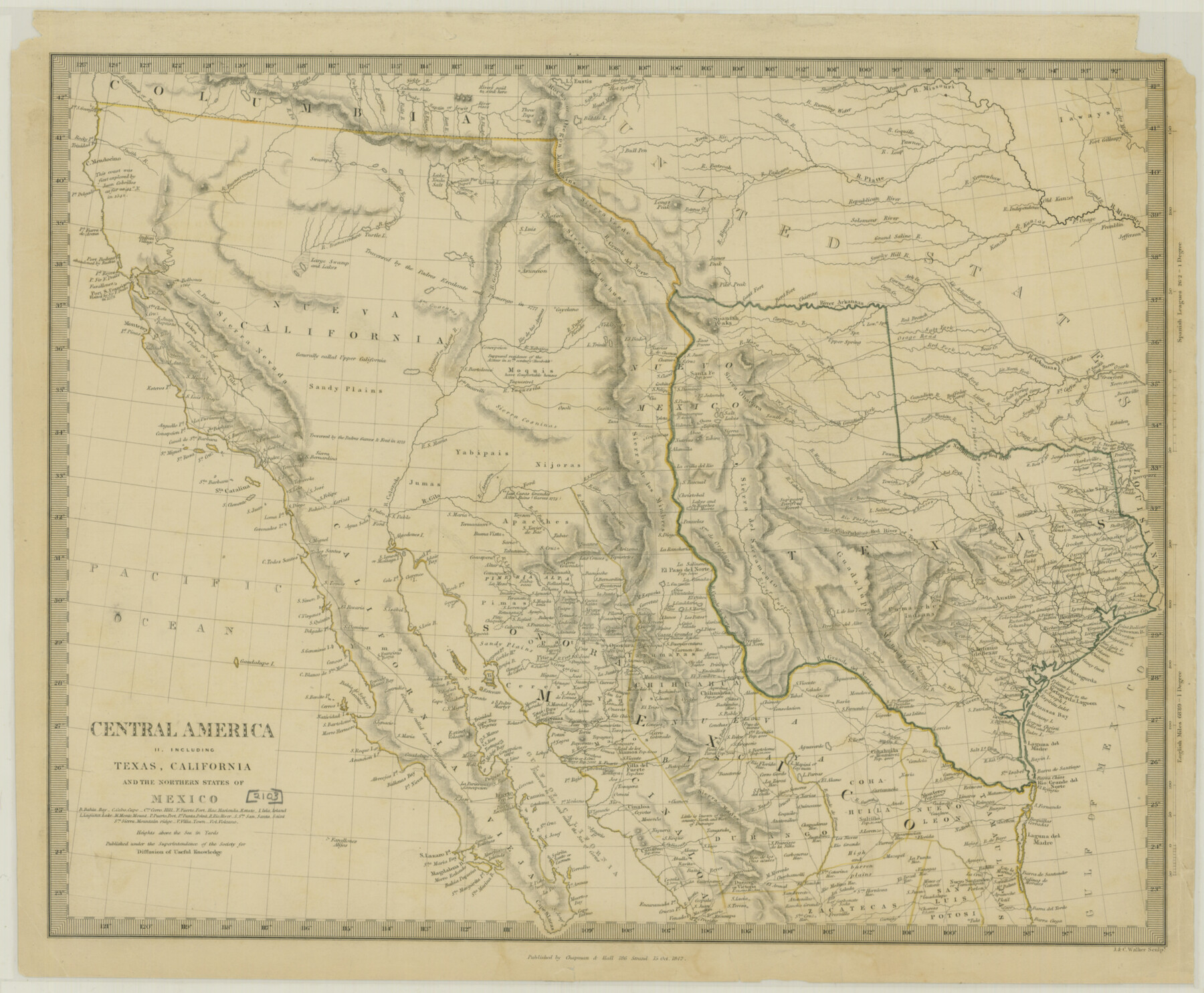
Central America Including Texas, California, and the Northern States Mexico
-
Map/Doc
76273
-
Collection
Texas State Library and Archives
-
Object Dates
1842 (Creation Date)
-
People and Organizations
Chapman and Hall (Publisher)
-
Subjects
Mexico Republic of Texas
-
Height x Width
13.8 x 16.7 inches
35.1 x 42.4 cm
-
Comments
Prints available courtesy of the Texas State Library and Archives.
More info can be found here: TSLAC Map 02344
Part of: Texas State Library and Archives
Corpus Christi is the Sportsman's Paradise

Print $20.00
Corpus Christi is the Sportsman's Paradise
1942
Size 26.7 x 16.3 inches
Map/Doc 79324
General Highway Map, Clay County, Texas

Print $20.00
General Highway Map, Clay County, Texas
1940
Size 25.2 x 18.6 inches
Map/Doc 79047
General Highway Map. Detail of Cities and Towns in Tarrant County, Texas. City Map, Fort Worth and vicinity, Tarrant County, Texas

Print $20.00
General Highway Map. Detail of Cities and Towns in Tarrant County, Texas. City Map, Fort Worth and vicinity, Tarrant County, Texas
1961
Size 18.2 x 24.8 inches
Map/Doc 79669
General Highway Map, Chambers County, Texas

Print $20.00
General Highway Map, Chambers County, Texas
1961
Size 18.3 x 24.8 inches
Map/Doc 79404
General Highway Map. Detail of Cities and Towns in Lubbock County, Texas [Lubbock and vicinity]
![79579, General Highway Map. Detail of Cities and Towns in Lubbock County, Texas [Lubbock and vicinity], Texas State Library and Archives](https://historictexasmaps.com/wmedia_w700/maps/79579.tif.jpg)
Print $20.00
General Highway Map. Detail of Cities and Towns in Lubbock County, Texas [Lubbock and vicinity]
1961
Size 18.2 x 24.7 inches
Map/Doc 79579
General Highway Map, Swisher County, Texas

Print $20.00
General Highway Map, Swisher County, Texas
1961
Size 18.3 x 25.0 inches
Map/Doc 79663
Railroad and County Map of Texas

Print $20.00
Railroad and County Map of Texas
1908
Size 44.5 x 45.8 inches
Map/Doc 76225
General Highway Map, Parker County, Texas

Print $20.00
General Highway Map, Parker County, Texas
1961
Size 18.3 x 24.5 inches
Map/Doc 79625
General Highway Map, Hardeman County, Texas

Print $20.00
General Highway Map, Hardeman County, Texas
1940
Size 25.0 x 18.3 inches
Map/Doc 79113
General Highway Map, Coryell County, Texas

Print $20.00
General Highway Map, Coryell County, Texas
1940
Size 18.4 x 25.4 inches
Map/Doc 79059
General Highway Map, Delta County, Hopkins County, Texas

Print $20.00
General Highway Map, Delta County, Hopkins County, Texas
1961
Size 24.6 x 18.2 inches
Map/Doc 79439
General Highway Map, Val Verde County, Texas

Print $20.00
General Highway Map, Val Verde County, Texas
1961
Size 24.9 x 18.1 inches
Map/Doc 79694
You may also like
Coast Chart No. 210 Aransas Pass and Corpus Christi Bay with the coast to latitude 27° 12' Texas

Print $20.00
- Digital $50.00
Coast Chart No. 210 Aransas Pass and Corpus Christi Bay with the coast to latitude 27° 12' Texas
1887
Size 27.1 x 18.5 inches
Map/Doc 72788
Map of Deaf Smith County, Texas

Print $2.00
- Digital $50.00
Map of Deaf Smith County, Texas
Size 11.6 x 8.9 inches
Map/Doc 90509
Nueces County Sketch File 52

Print $10.00
- Digital $50.00
Nueces County Sketch File 52
1947
Size 14.1 x 8.6 inches
Map/Doc 32858

United States - Gulf Coast - Galveston to Rio Grande

Print $20.00
- Digital $50.00
United States - Gulf Coast - Galveston to Rio Grande
1919
Size 26.9 x 18.2 inches
Map/Doc 72743
Edwards County Working Sketch 139

Print $20.00
- Digital $50.00
Edwards County Working Sketch 139
Size 20.9 x 21.4 inches
Map/Doc 62184
Zavala County Sketch File 11a

Print $10.00
- Digital $50.00
Zavala County Sketch File 11a
1885
Size 11.2 x 8.6 inches
Map/Doc 41272
Terrell County Working Sketch 25

Print $40.00
- Digital $50.00
Terrell County Working Sketch 25
1942
Size 41.9 x 49.1 inches
Map/Doc 62175
Upton County Sketch File 29

Print $40.00
- Digital $50.00
Upton County Sketch File 29
1935
Size 16.9 x 14.4 inches
Map/Doc 38881

Wise County Working Sketch 17

Print $20.00
- Digital $50.00
Wise County Working Sketch 17
1972
Size 29.9 x 25.0 inches
Map/Doc 72631
General Highway Map, Winkler County, Texas

Print $20.00
General Highway Map, Winkler County, Texas
1940
Size 18.4 x 24.7 inches
Map/Doc 79283