Nueces County Sketch File 52
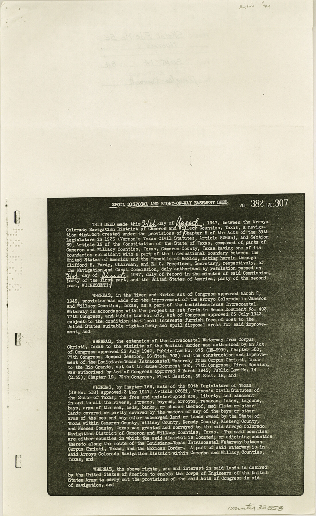
[Spoil disposal and right-of-way easement deed]
-
Map/Doc
32858
-
Collection
General Map Collection
-
Object Dates
11/13/1947 (Creation Date)
9/14/1984 (File Date)
-
Counties
Nueces Cameron Willacy Kenedy Kleberg
-
Subjects
Surveying Sketch File
-
Height x Width
14.1 x 8.6 inches
35.8 x 21.8 cm
-
Medium
photostat, negative
-
Features
Intracoastal Waterway
Corpus Christi
Rio Grande
Arroyo Colorado
Louisiana-Texas Intracoastal Waterway
Corpus Christi Bay
Laguna Madre
Part of: General Map Collection
Blocks No. 8, 9 & 10 Houston & Great Northern Rail Road Company Surveys in Pecos County, Texas

Print $20.00
- Digital $50.00
Blocks No. 8, 9 & 10 Houston & Great Northern Rail Road Company Surveys in Pecos County, Texas
1891
Size 24.5 x 38.7 inches
Map/Doc 3955
Hunt County Sketch File 43

Print $6.00
- Digital $50.00
Hunt County Sketch File 43
1851
Size 8.4 x 13.0 inches
Map/Doc 27165
Flight Mission No. CGI-1N, Frame 214, Cameron County

Print $20.00
- Digital $50.00
Flight Mission No. CGI-1N, Frame 214, Cameron County
1955
Size 18.5 x 22.1 inches
Map/Doc 84523
Cameron County Sketch File 12

Print $222.00
- Digital $50.00
Cameron County Sketch File 12
Size 10.8 x 7.4 inches
Map/Doc 17236
Greer County Sketch File 1

Print $20.00
- Digital $50.00
Greer County Sketch File 1
Size 27.8 x 19.7 inches
Map/Doc 11581
Harris County Rolled Sketch ACS

Print $40.00
- Digital $50.00
Harris County Rolled Sketch ACS
1933
Size 32.7 x 52.8 inches
Map/Doc 8343
Kimble County Rolled Sketch 20

Print $20.00
- Digital $50.00
Kimble County Rolled Sketch 20
Size 14.6 x 18.1 inches
Map/Doc 6511
Guadalupe County Sketch File 1a

Print $4.00
- Digital $50.00
Guadalupe County Sketch File 1a
1859
Size 12.6 x 7.9 inches
Map/Doc 24646
Zavala County Sketch File 1

Print $20.00
- Digital $50.00
Zavala County Sketch File 1
Size 28.5 x 22.7 inches
Map/Doc 12725
Kendall County Working Sketch 2

Print $20.00
- Digital $50.00
Kendall County Working Sketch 2
1941
Size 28.6 x 21.1 inches
Map/Doc 66674
Parker County Working Sketch 1

Print $20.00
- Digital $50.00
Parker County Working Sketch 1
Size 22.6 x 17.0 inches
Map/Doc 71451
Sutton County Working Sketch 67

Print $20.00
- Digital $50.00
Sutton County Working Sketch 67
1972
Size 37.7 x 36.7 inches
Map/Doc 62410
You may also like
J. De Cordova's Map of the State of Texas Compiled from the records of the General Land Office of the State

Print $20.00
J. De Cordova's Map of the State of Texas Compiled from the records of the General Land Office of the State
1872
Size 34.3 x 31.9 inches
Map/Doc 76216
Burleson County Working Sketch 2

Print $20.00
- Digital $50.00
Burleson County Working Sketch 2
1976
Size 36.4 x 31.2 inches
Map/Doc 67721
No. 3 Chart of Channel connecting Corpus Christi Bay with Aransas Bay, Texas

Print $20.00
- Digital $50.00
No. 3 Chart of Channel connecting Corpus Christi Bay with Aransas Bay, Texas
1878
Size 18.3 x 28.0 inches
Map/Doc 72773
Haskell County Working Sketch 13

Print $20.00
- Digital $50.00
Haskell County Working Sketch 13
1983
Size 33.0 x 41.8 inches
Map/Doc 66071
Val Verde County Rolled Sketch 62

Print $40.00
- Digital $50.00
Val Verde County Rolled Sketch 62
1956
Size 34.6 x 52.1 inches
Map/Doc 10081
Flight Mission No. DIX-5P, Frame 145, Aransas County

Print $20.00
- Digital $50.00
Flight Mission No. DIX-5P, Frame 145, Aransas County
1956
Size 17.8 x 18.1 inches
Map/Doc 83806
Mitchell County Sketch File 18

Print $20.00
- Digital $50.00
Mitchell County Sketch File 18
Size 32.1 x 13.6 inches
Map/Doc 12103
Aransas County Boundary File 6

Print $156.00
- Digital $50.00
Aransas County Boundary File 6
Size 14.1 x 8.5 inches
Map/Doc 49806
Morris County Rolled Sketch 2A

Print $20.00
- Digital $50.00
Morris County Rolled Sketch 2A
Size 24.3 x 19.2 inches
Map/Doc 10255
Flight Mission No. BRA-16M, Frame 67, Jefferson County

Print $20.00
- Digital $50.00
Flight Mission No. BRA-16M, Frame 67, Jefferson County
1953
Size 18.6 x 22.4 inches
Map/Doc 85684
Map of Atascosa County

Print $20.00
- Digital $50.00
Map of Atascosa County
1879
Size 24.5 x 24.8 inches
Map/Doc 3250
Roberts County Working Sketch 46

Print $20.00
- Digital $50.00
Roberts County Working Sketch 46
1979
Size 19.4 x 28.3 inches
Map/Doc 63572