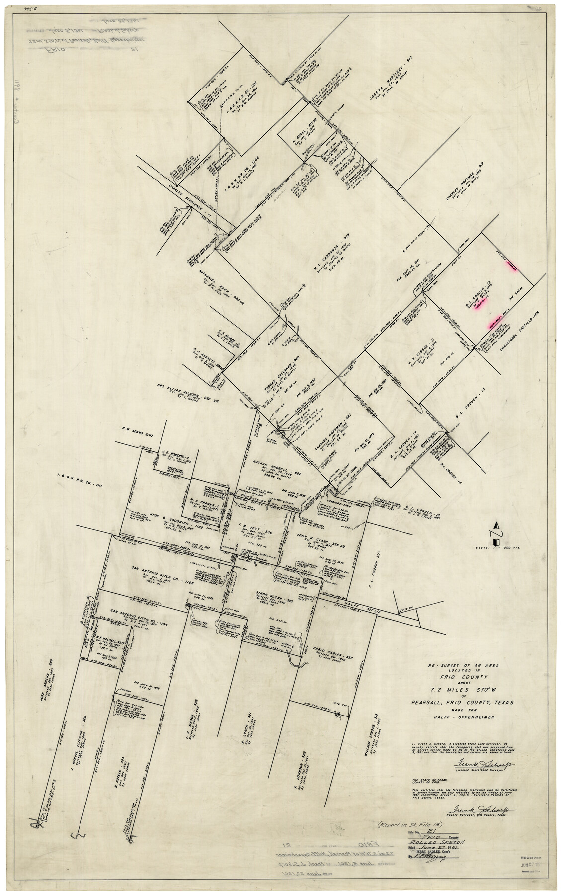
Frio County Rolled Sketch 21
Re-Survey of an area located in Frio County about 7.2 miles S70°W of Pearsall, Frio County, Texas
-
Map/Doc
8911
-
Collection
General Map Collection
-
Object Dates
6/5/1961 (Creation Date)
6/27/1961 (File Date)
-
People and Organizations
Frank J. Schorp (Surveyor/Engineer)
-
Counties
Frio
-
Subjects
Surveying Rolled Sketch
-
Height x Width
43.8 x 27.7 inches
111.3 x 70.4 cm
-
Medium
linen, manuscript
-
Scale
1" = 500 varas
Part of: General Map Collection
Jackson County Rolled Sketch 9

Print $40.00
- Digital $50.00
Jackson County Rolled Sketch 9
1941
Size 50.7 x 32.1 inches
Map/Doc 9258
Tyler County Rolled Sketch 12

Print $20.00
- Digital $50.00
Tyler County Rolled Sketch 12
1988
Size 25.2 x 19.3 inches
Map/Doc 8060
Midland County Sketch File 3

Print $20.00
- Digital $50.00
Midland County Sketch File 3
1886
Size 18.3 x 25.2 inches
Map/Doc 12081
Hemphill County Rolled Sketch 11

Print $20.00
- Digital $50.00
Hemphill County Rolled Sketch 11
1941
Size 45.1 x 21.8 inches
Map/Doc 9153
Knox County Working Sketch 18

Print $20.00
- Digital $50.00
Knox County Working Sketch 18
1988
Size 40.0 x 29.7 inches
Map/Doc 70260

Galveston County Sketch File 74

Print $12.00
- Digital $50.00
Galveston County Sketch File 74
2002
Size 11.3 x 8.7 inches
Map/Doc 77526
Cherokee County Working Sketch 3

Print $20.00
- Digital $50.00
Cherokee County Working Sketch 3
1934
Size 29.6 x 42.7 inches
Map/Doc 67958
Polk County Working Sketch 34

Print $20.00
- Digital $50.00
Polk County Working Sketch 34
1961
Size 41.3 x 42.0 inches
Map/Doc 71651
Kimble County Rolled Sketch 21

Print $20.00
- Digital $50.00
Kimble County Rolled Sketch 21
Size 10.5 x 18.2 inches
Map/Doc 6512
Map and Profile No. 1 from the Red River to the Rio Grande; from explorations and surveys made under the direction of the Hon. Jefferson Davis, Secretary of War by Captain John Pope, Corps. Topl Engrs.

Print $40.00
- Digital $50.00
Map and Profile No. 1 from the Red River to the Rio Grande; from explorations and surveys made under the direction of the Hon. Jefferson Davis, Secretary of War by Captain John Pope, Corps. Topl Engrs.
Size 30.2 x 59.9 inches
Map/Doc 95176
Hudspeth County Rolled Sketch 54

Print $177.00
- Digital $50.00
Hudspeth County Rolled Sketch 54
1977
Size 10.2 x 15.0 inches
Map/Doc 45887
You may also like
Flight Mission No. DQN-2K, Frame 66, Calhoun County

Print $20.00
- Digital $50.00
Flight Mission No. DQN-2K, Frame 66, Calhoun County
1953
Size 18.9 x 22.3 inches
Map/Doc 84258
Cottle County Sketch File 8

Print $20.00
- Digital $50.00
Cottle County Sketch File 8
1894
Size 37.6 x 17.6 inches
Map/Doc 11192
Flight Mission No. CGI-3N, Frame 136, Cameron County

Print $20.00
- Digital $50.00
Flight Mission No. CGI-3N, Frame 136, Cameron County
1954
Size 18.6 x 22.3 inches
Map/Doc 84609
James Heights, an addition to the City of Lubbock - tracts 4, 5, 6, 7, 8, 9, 10, 11, 12, 13 in Block 7, and tracts 4, 5, 6, 7, 8, 9, 10, 11, 12, 13 in Block 8 of the Clutter Addition

Print $3.00
- Digital $50.00
James Heights, an addition to the City of Lubbock - tracts 4, 5, 6, 7, 8, 9, 10, 11, 12, 13 in Block 7, and tracts 4, 5, 6, 7, 8, 9, 10, 11, 12, 13 in Block 8 of the Clutter Addition
1949
Size 10.1 x 11.4 inches
Map/Doc 92704
Dickens County Rolled Sketch 7

Print $20.00
- Digital $50.00
Dickens County Rolled Sketch 7
1947
Size 33.6 x 23.6 inches
Map/Doc 5706
Map of the United States

Print $20.00
- Digital $50.00
Map of the United States
1851
Size 24.7 x 26.0 inches
Map/Doc 96632
Map of Escarpment Section through Webb County, Texas (North half of Webb County)

Print $40.00
- Digital $50.00
Map of Escarpment Section through Webb County, Texas (North half of Webb County)
1925
Size 43.3 x 76.3 inches
Map/Doc 93162
Dimmit County Working Sketch 11

Print $20.00
- Digital $50.00
Dimmit County Working Sketch 11
1935
Size 28.7 x 31.7 inches
Map/Doc 68672
Wharton County Working Sketch 8

Print $20.00
- Digital $50.00
Wharton County Working Sketch 8
1983
Size 37.2 x 32.3 inches
Map/Doc 72472
Harris County Working Sketch 45

Print $20.00
- Digital $50.00
Harris County Working Sketch 45
1942
Size 26.6 x 31.9 inches
Map/Doc 65937
Bosque County Working Sketch 17

Print $20.00
- Digital $50.00
Bosque County Working Sketch 17
1975
Size 18.3 x 21.1 inches
Map/Doc 67450
Refugio County Working Sketch 13

Print $20.00
- Digital $50.00
Refugio County Working Sketch 13
1961
Size 23.8 x 29.8 inches
Map/Doc 63522