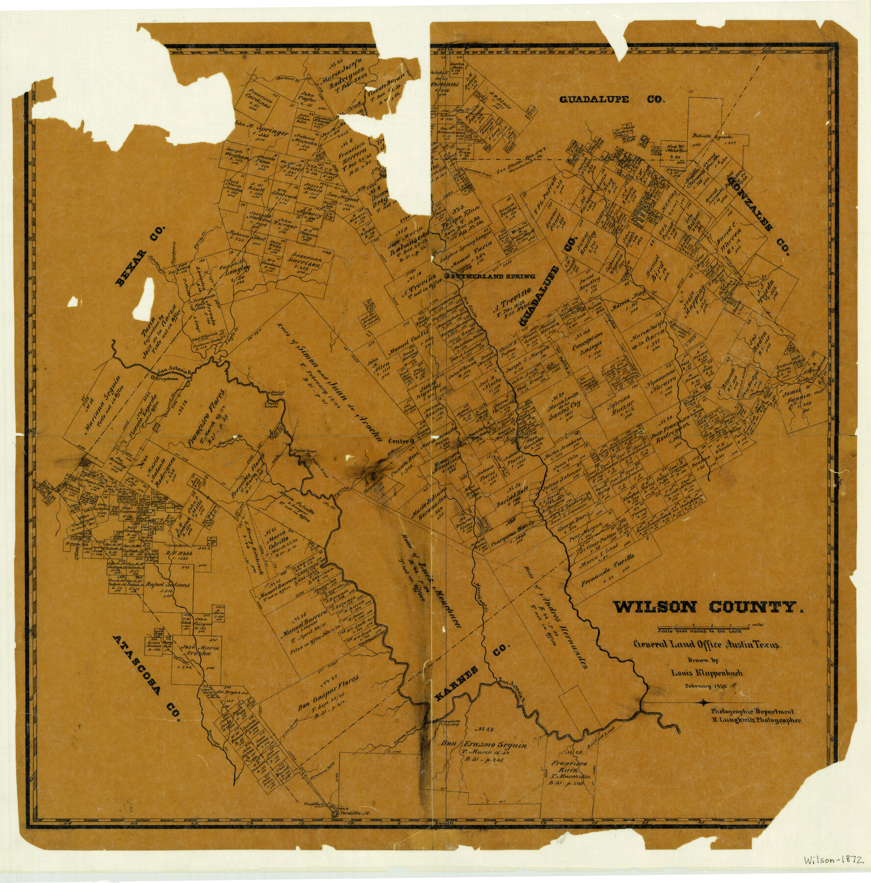
Wilson County
-
Map/Doc
1618
-
Collection
General Map Collection
-
Object Dates
1872 (Creation Date)
-
People and Organizations
Texas General Land Office (Publisher)
Herman Lungkwitz (Draftsman)
L. Klappenbach (Draftsman)
-
Counties
Wilson
-
Subjects
County
-
Height x Width
22.4 x 22.1 inches
56.9 x 56.1 cm
-
Features
Mustang Creek
Matamoros Road
Tordilla Creek
Tordilla Mountain
Conquista Crossing
Espanta Parros Creek
Los Cortos Creek
Borrego Creek
Los Prietos Creek
Marcelinas Creek
Lucas Creek
Pajaritos Creek
Mariana Creek
La Bahia Road
E. Seguin's House
F. Flores Rancho
Calaveros Creek
Elm Creek
Arocha's Rancho
Eagle Creek
San Antonio River
Graytown [sic]
Rio Cibolo
Sutherland Springs
Sulphur Spring
Clear Creek
Gonzales Road
Sandy Creek
Martinez Creek
Parita Creek
Chupederas Creek
Part of: General Map Collection
Briscoe County Sketch File P

Print $40.00
- Digital $50.00
Briscoe County Sketch File P
Size 23.1 x 34.0 inches
Map/Doc 11014
Pecos County Working Sketch 112

Print $40.00
- Digital $50.00
Pecos County Working Sketch 112
Size 48.1 x 37.0 inches
Map/Doc 71585
Fannin County Sketch File 20

Print $14.00
- Digital $50.00
Fannin County Sketch File 20
1889
Size 4.2 x 5.1 inches
Map/Doc 22475
Howard County

Print $20.00
- Digital $50.00
Howard County
1922
Size 40.3 x 34.6 inches
Map/Doc 77318
Chambers County Working Sketch 9

Print $20.00
- Digital $50.00
Chambers County Working Sketch 9
1946
Size 43.9 x 29.8 inches
Map/Doc 67992
El Paso County Sketch File 26

Print $20.00
- Digital $50.00
El Paso County Sketch File 26
Size 24.8 x 21.9 inches
Map/Doc 11457
Pecos County Working Sketch 62

Print $40.00
- Digital $50.00
Pecos County Working Sketch 62
1952
Size 32.3 x 59.1 inches
Map/Doc 71534
Sutton County Sketch File 27a

Print $6.00
- Digital $50.00
Sutton County Sketch File 27a
Size 11.3 x 8.8 inches
Map/Doc 37466
Upton County Working Sketch 2

Print $20.00
- Digital $50.00
Upton County Working Sketch 2
1906
Size 31.3 x 22.0 inches
Map/Doc 69498
Childress County Rolled Sketch 10

Print $20.00
- Digital $50.00
Childress County Rolled Sketch 10
1940
Size 43.6 x 12.0 inches
Map/Doc 8601
Orange County Working Sketch 39

Print $20.00
- Digital $50.00
Orange County Working Sketch 39
1966
Size 20.5 x 27.8 inches
Map/Doc 71371
Shackelford County Rolled Sketch 3

Print $40.00
- Digital $50.00
Shackelford County Rolled Sketch 3
1955
Size 35.4 x 49.9 inches
Map/Doc 9915
You may also like
Hopkins County Sketch File 1

Print $4.00
- Digital $50.00
Hopkins County Sketch File 1
1854
Size 5.2 x 10.2 inches
Map/Doc 26676
DeWitt County Working Sketch 15

Print $20.00
- Digital $50.00
DeWitt County Working Sketch 15
1991
Size 30.0 x 42.1 inches
Map/Doc 68605
Hispaniae Novae Sivae Magnae Recens et Vera Descriptio 1579

Print $20.00
- Digital $50.00
Hispaniae Novae Sivae Magnae Recens et Vera Descriptio 1579
1581
Size 17.9 x 23.0 inches
Map/Doc 94036
Franklin County

Print $20.00
- Digital $50.00
Franklin County
1897
Size 35.1 x 14.3 inches
Map/Doc 3556
Aransas Pass to Baffin Bay

Print $20.00
- Digital $50.00
Aransas Pass to Baffin Bay
1949
Size 42.6 x 34.7 inches
Map/Doc 73413
'O Bar O' Ranch

Print $40.00
- Digital $50.00
'O Bar O' Ranch
1946
Size 47.8 x 82.6 inches
Map/Doc 93202
Guadalupe County Working Sketch 3

Print $20.00
- Digital $50.00
Guadalupe County Working Sketch 3
1980
Size 17.1 x 16.5 inches
Map/Doc 63312
Hartley County Sketch File 5

Print $8.00
- Digital $50.00
Hartley County Sketch File 5
1883
Size 12.7 x 8.1 inches
Map/Doc 26090
Eastland County Working Sketch Graphic Index

Print $20.00
- Digital $50.00
Eastland County Working Sketch Graphic Index
1945
Size 41.6 x 42.4 inches
Map/Doc 76529
Sabine County Working Sketch 2

Print $3.00
- Digital $50.00
Sabine County Working Sketch 2
1906
Size 12.5 x 10.8 inches
Map/Doc 63673
Upshur County

Print $20.00
- Digital $50.00
Upshur County
1945
Size 40.3 x 36.2 inches
Map/Doc 63085
Leon County Working Sketch Graphic Index

Print $20.00
- Digital $50.00
Leon County Working Sketch Graphic Index
1977
Size 46.8 x 41.5 inches
Map/Doc 76618