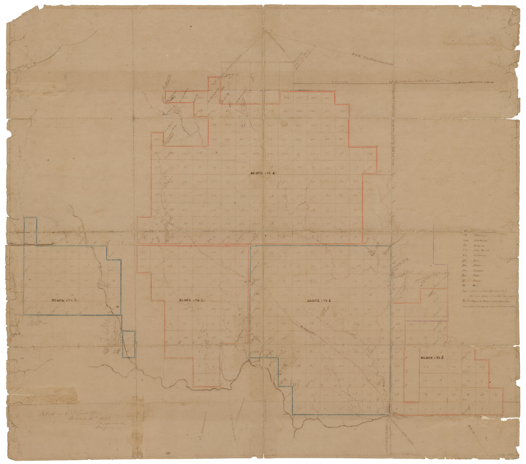
Kent County Rolled Sketch 8
[Sketch of Blocks 1, 2, 3, 4, and 5]
-
Map/Doc
9344
-
Collection
General Map Collection
-
Object Dates
1873/9/2 (Creation Date)
1873/10/26 (File Date)
-
Counties
Kent
-
Subjects
Surveying Rolled Sketch
-
Height x Width
31.5 x 35.5 inches
80.0 x 90.2 cm
-
Medium
paper, manuscript
-
Comments
Shows General McKenzie's Trail. Conservation funded in 2013 by Friends of the Texas General Land Office.
-
Features
Gen. McKenzie's Trail
Part of: General Map Collection
Missouri Pacific Railway System

Print $20.00
- Digital $50.00
Missouri Pacific Railway System
1888
Size 20.0 x 20.0 inches
Map/Doc 89223
[Surveys in the Bexar District along the Sabinal and Frio Rivers]
![3167, [Surveys in the Bexar District along the Sabinal and Frio Rivers], General Map Collection](https://historictexasmaps.com/wmedia_w700/maps/3167.tif.jpg)
Print $20.00
- Digital $50.00
[Surveys in the Bexar District along the Sabinal and Frio Rivers]
1846
Size 16.8 x 19.6 inches
Map/Doc 3167
Map of Hall County

Print $20.00
- Digital $50.00
Map of Hall County
1900
Size 41.2 x 41.3 inches
Map/Doc 16842
Harris County Rolled Sketch 77

Print $20.00
- Digital $50.00
Harris County Rolled Sketch 77
1914
Size 30.0 x 35.6 inches
Map/Doc 6114
Brooks County Rolled Sketch 22

Print $20.00
- Digital $50.00
Brooks County Rolled Sketch 22
1943
Size 15.1 x 32.2 inches
Map/Doc 5343
Flight Mission No. DQN-1K, Frame 156, Calhoun County

Print $20.00
- Digital $50.00
Flight Mission No. DQN-1K, Frame 156, Calhoun County
1953
Size 18.6 x 22.3 inches
Map/Doc 84215
Colorado County Working Sketch 7

Print $20.00
- Digital $50.00
Colorado County Working Sketch 7
1922
Size 23.8 x 23.2 inches
Map/Doc 68107
Young County Rolled Sketch 7

Print $20.00
- Digital $50.00
Young County Rolled Sketch 7
Size 37.3 x 26.4 inches
Map/Doc 8295
Milam County Boundary File 3

Print $16.00
- Digital $50.00
Milam County Boundary File 3
Size 13.9 x 8.5 inches
Map/Doc 57213
Harris County Sketch File 19

Print $4.00
- Digital $50.00
Harris County Sketch File 19
1862
Size 8.7 x 13.9 inches
Map/Doc 25366
Hudspeth County Sketch File 24

Print $20.00
- Digital $50.00
Hudspeth County Sketch File 24
1936
Size 17.8 x 16.7 inches
Map/Doc 11802
Henderson County Rolled Sketch 8

Print $40.00
- Digital $50.00
Henderson County Rolled Sketch 8
1963
Size 37.3 x 50.9 inches
Map/Doc 9164
You may also like
Culberson County Working Sketch 85

Print $20.00
- Digital $50.00
Culberson County Working Sketch 85
1981
Size 37.0 x 36.9 inches
Map/Doc 68539
Coke County Sketch File 14

Print $6.00
- Digital $50.00
Coke County Sketch File 14
1891
Size 10.8 x 13.1 inches
Map/Doc 18598
Texas State Capitol Land

Print $40.00
- Digital $50.00
Texas State Capitol Land
1915
Size 76.5 x 55.6 inches
Map/Doc 93155
Trinity County Rolled Sketch 6

Print $20.00
- Digital $50.00
Trinity County Rolled Sketch 6
1999
Size 25.0 x 19.3 inches
Map/Doc 8053
Texas Intracoastal Waterway - Laguna Madre - Rincon de San Jose to Chubby Island

Print $20.00
- Digital $50.00
Texas Intracoastal Waterway - Laguna Madre - Rincon de San Jose to Chubby Island
1961
Size 38.0 x 26.7 inches
Map/Doc 73514
Working Sketch Hutchinson County

Print $20.00
- Digital $50.00
Working Sketch Hutchinson County
1920
Size 43.4 x 37.2 inches
Map/Doc 89709
Hockley County

Print $20.00
- Digital $50.00
Hockley County
1954
Size 42.9 x 38.9 inches
Map/Doc 1856
Jefferson County Rolled Sketch 58

Print $40.00
- Digital $50.00
Jefferson County Rolled Sketch 58
1897
Size 21.4 x 60.3 inches
Map/Doc 9312
University of Texas System University Lands

Print $20.00
- Digital $50.00
University of Texas System University Lands
1938
Size 17.8 x 23.4 inches
Map/Doc 93247

Flight Mission No. DCL-7C, Frame 8, Kenedy County

Print $20.00
- Digital $50.00
Flight Mission No. DCL-7C, Frame 8, Kenedy County
1943
Size 15.4 x 15.2 inches
Map/Doc 86000
Lampasas County Sketch File 5

Print $8.00
- Digital $50.00
Lampasas County Sketch File 5
1869
Size 12.8 x 7.9 inches
Map/Doc 29396