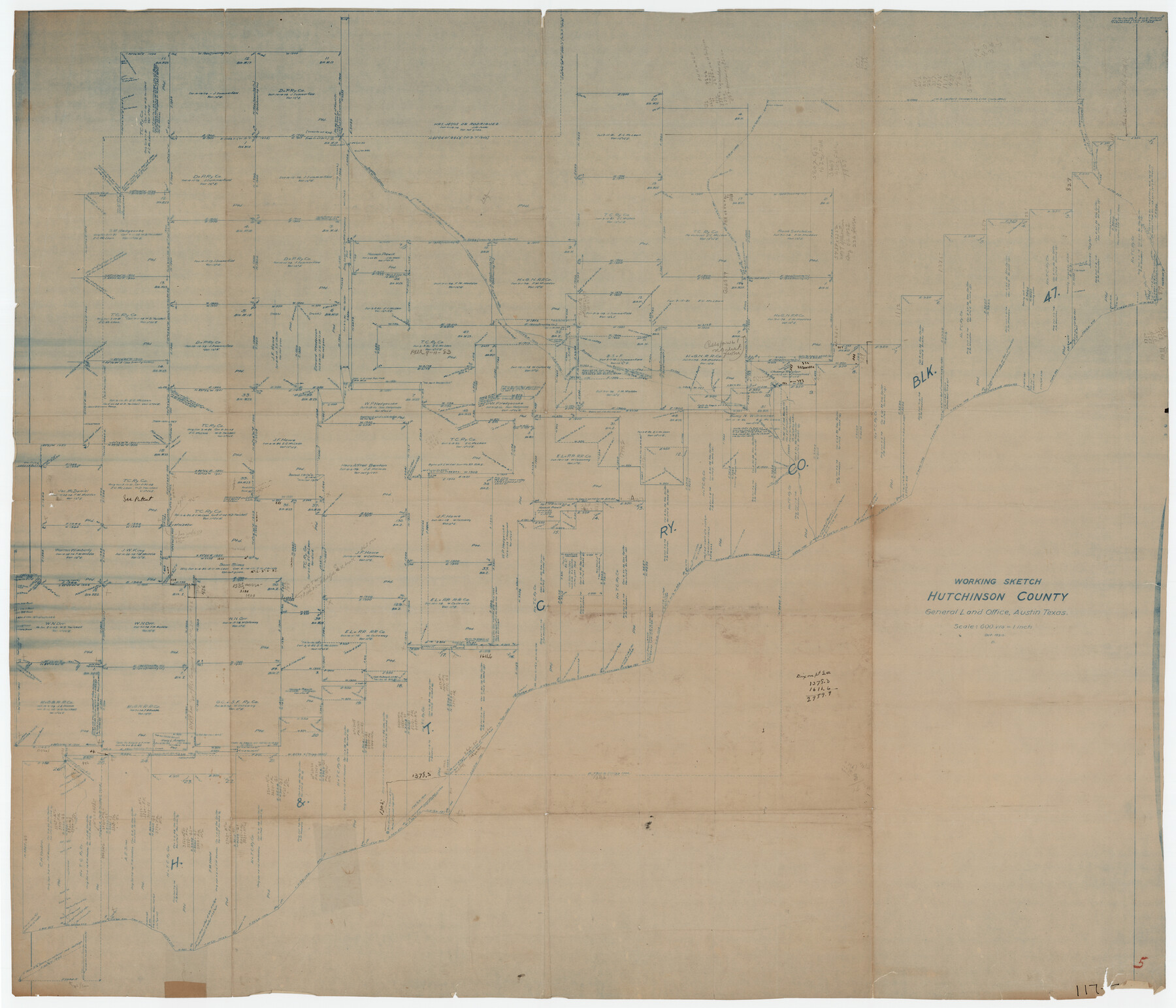
Working Sketch Hutchinson County
117-7
-
Map/Doc
89709
-
Collection
Twichell Survey Records
-
Object Dates
10/1920 (Creation Date)
-
Counties
Hutchinson
-
Height x Width
43.4 x 37.2 inches
110.2 x 94.5 cm
Related maps
Hutchinson County Sketch File 42

Print $9.00
- Digital $50.00
Hutchinson County Sketch File 42
1920
Size 14.3 x 8.9 inches
Map/Doc 27305
Part of: Twichell Survey Records
Lgs. 276 thru 280-289, 333, 336, 345, 355 thru 357, 367, Blk. K11

Print $20.00
- Digital $50.00
Lgs. 276 thru 280-289, 333, 336, 345, 355 thru 357, 367, Blk. K11
Size 28.0 x 12.3 inches
Map/Doc 91429
[Blocks 44, 6T, 26, B10, and B12]
![91528, [Blocks 44, 6T, 26, B10, and B12], Twichell Survey Records](https://historictexasmaps.com/wmedia_w700/maps/91528-1.tif.jpg)
Print $20.00
- Digital $50.00
[Blocks 44, 6T, 26, B10, and B12]
Size 19.7 x 15.8 inches
Map/Doc 91528
[Blocks A, S4, T2, MO, and vicinity]
![91067, [Blocks A, S4, T2, MO, and vicinity], Twichell Survey Records](https://historictexasmaps.com/wmedia_w700/maps/91067-1.tif.jpg)
Print $3.00
- Digital $50.00
[Blocks A, S4, T2, MO, and vicinity]
Size 15.3 x 10.7 inches
Map/Doc 91067
[Leagues 152 and 153]
![90287, [Leagues 152 and 153], Twichell Survey Records](https://historictexasmaps.com/wmedia_w700/maps/90287-1.tif.jpg)
Print $20.00
- Digital $50.00
[Leagues 152 and 153]
Size 16.4 x 22.4 inches
Map/Doc 90287
Ater Heights Section 44, Block AK

Print $20.00
- Digital $50.00
Ater Heights Section 44, Block AK
1952
Size 11.9 x 18.9 inches
Map/Doc 92347
Ownership Map SE 1/4 Lubbock County

Print $20.00
- Digital $50.00
Ownership Map SE 1/4 Lubbock County
Size 36.6 x 35.9 inches
Map/Doc 89898
Working Sketch in Armstrong County

Print $20.00
- Digital $50.00
Working Sketch in Armstrong County
1918
Size 31.5 x 24.3 inches
Map/Doc 90265
S. F. Singleton's Lands Sold to H. B. Herd, Located in Southwest Part of Lynn County

Print $20.00
- Digital $50.00
S. F. Singleton's Lands Sold to H. B. Herd, Located in Southwest Part of Lynn County
1908
Size 12.1 x 23.1 inches
Map/Doc 91339
[Blocks C & C2]
![90747, [Blocks C & C2], Twichell Survey Records](https://historictexasmaps.com/wmedia_w700/maps/90747-1.tif.jpg)
Print $20.00
- Digital $50.00
[Blocks C & C2]
1906
Size 24.7 x 8.9 inches
Map/Doc 90747
[H. & T. C. Block 47, Sections 47- 55 Corrections]
![91529, [H. & T. C. Block 47, Sections 47- 55 Corrections], Twichell Survey Records](https://historictexasmaps.com/wmedia_w700/maps/91529-1.tif.jpg)
Print $3.00
- Digital $50.00
[H. & T. C. Block 47, Sections 47- 55 Corrections]
Size 11.6 x 13.3 inches
Map/Doc 91529
[Central Part of County]
![89791, [Central Part of County], Twichell Survey Records](https://historictexasmaps.com/wmedia_w700/maps/89791-1.tif.jpg)
Print $40.00
- Digital $50.00
[Central Part of County]
Size 70.0 x 26.3 inches
Map/Doc 89791
W. L. Ellwood's Subdivision of Parts of Leagues 9 and 10, Donley County School Land, 7 Wilbarger County School Land and Parts of Section 50, 61, and 74, Block 20 Hockley County, Texas

Print $20.00
- Digital $50.00
W. L. Ellwood's Subdivision of Parts of Leagues 9 and 10, Donley County School Land, 7 Wilbarger County School Land and Parts of Section 50, 61, and 74, Block 20 Hockley County, Texas
1923
Size 20.2 x 19.8 inches
Map/Doc 92249
You may also like
Tarrant County

Print $20.00
- Digital $50.00
Tarrant County
1873
Size 18.6 x 17.4 inches
Map/Doc 4631
Robertson County Working Sketch 18

Print $20.00
- Digital $50.00
Robertson County Working Sketch 18
1995
Size 29.9 x 34.1 inches
Map/Doc 63591
The Republic County of Bowie. December 29, 1845

Print $20.00
The Republic County of Bowie. December 29, 1845
2020
Size 19.5 x 21.7 inches
Map/Doc 96108
Flight Mission No. CRC-4R, Frame 103, Chambers County

Print $20.00
- Digital $50.00
Flight Mission No. CRC-4R, Frame 103, Chambers County
1956
Size 18.4 x 22.3 inches
Map/Doc 84900
Brazos River, Brazos River Sheet 3

Print $6.00
- Digital $50.00
Brazos River, Brazos River Sheet 3
1926
Size 21.8 x 34.6 inches
Map/Doc 65296
[Right of Way & Track Map, The Texas & Pacific Ry. Co. Main Line]
![64669, [Right of Way & Track Map, The Texas & Pacific Ry. Co. Main Line], General Map Collection](https://historictexasmaps.com/wmedia_w700/maps/64669.tif.jpg)
Print $20.00
- Digital $50.00
[Right of Way & Track Map, The Texas & Pacific Ry. Co. Main Line]
Size 11.0 x 18.5 inches
Map/Doc 64669
Map of Brazos County, Texas

Print $40.00
- Digital $50.00
Map of Brazos County, Texas
1926
Size 89.6 x 55.1 inches
Map/Doc 93648
Flight Mission No. CUG-2P, Frame 84, Kleberg County

Print $20.00
- Digital $50.00
Flight Mission No. CUG-2P, Frame 84, Kleberg County
1956
Size 18.6 x 22.3 inches
Map/Doc 86216
Hunt County Working Sketch 1

Print $20.00
- Digital $50.00
Hunt County Working Sketch 1
Size 18.2 x 17.2 inches
Map/Doc 66348
Texas - Rand McNally Indexed Pocket Map - Tourists' and Shippers' Guide - Main Highways, Railroads, and Electric Lines, Counties, Cities, Towns, Villages, Post Offices, Lakes, Rivers, etc.

Texas - Rand McNally Indexed Pocket Map - Tourists' and Shippers' Guide - Main Highways, Railroads, and Electric Lines, Counties, Cities, Towns, Villages, Post Offices, Lakes, Rivers, etc.
1924
Map/Doc 95854
Flight Mission No. DQN-5K, Frame 29, Calhoun County

Print $20.00
- Digital $50.00
Flight Mission No. DQN-5K, Frame 29, Calhoun County
1953
Size 18.5 x 22.3 inches
Map/Doc 84380
Matagorda County Rolled Sketch 15

Print $20.00
- Digital $50.00
Matagorda County Rolled Sketch 15
Size 24.5 x 14.9 inches
Map/Doc 6682