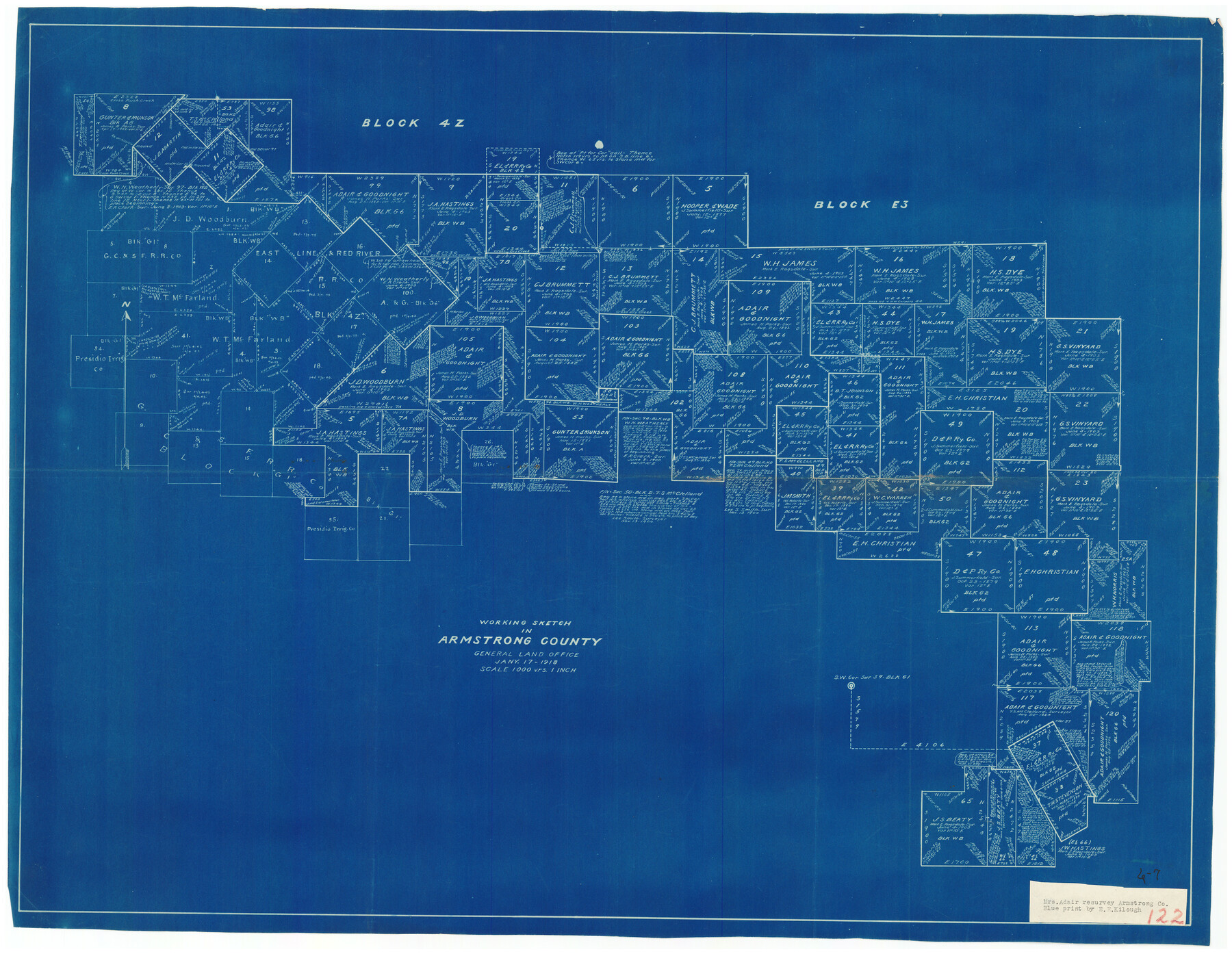
Working Sketch in Armstrong County
6-7
-
Map/Doc
90265
-
Collection
Twichell Survey Records
-
Object Dates
1/17/1918 (Creation Date)
-
People and Organizations
General Land Office (Publisher)
-
Counties
Armstrong
-
Height x Width
31.5 x 24.3 inches
80.0 x 61.7 cm
Part of: Twichell Survey Records
Sketch Showing Division Fence Shelton- Matador, Oldham County

Print $20.00
- Digital $50.00
Sketch Showing Division Fence Shelton- Matador, Oldham County
Size 21.6 x 24.4 inches
Map/Doc 91484
[Lubbock, Crosby County Line]
![91323, [Lubbock, Crosby County Line], Twichell Survey Records](https://historictexasmaps.com/wmedia_w700/maps/91323-1.tif.jpg)
Print $2.00
- Digital $50.00
[Lubbock, Crosby County Line]
Size 9.2 x 14.7 inches
Map/Doc 91323
Brazos River Conservation and Reclamation District Official Boundary Line Survey

Print $20.00
- Digital $50.00
Brazos River Conservation and Reclamation District Official Boundary Line Survey
Size 37.3 x 24.7 inches
Map/Doc 90129
William P. White Subdivision of 2.45 Acres out of North Half of Survey 1, Block 36, Township 5 North, Dawson County, Texas

Print $20.00
- Digital $50.00
William P. White Subdivision of 2.45 Acres out of North Half of Survey 1, Block 36, Township 5 North, Dawson County, Texas
1924
Size 18.6 x 24.7 inches
Map/Doc 92575

[Guadalupe College]
![91907, [Guadalupe College], Twichell Survey Records](https://historictexasmaps.com/wmedia_w700/maps/91907-1.tif.jpg)
Print $3.00
- Digital $50.00
[Guadalupe College]
Size 16.7 x 9.7 inches
Map/Doc 91907
T. & P. RR. Co. Township 1 South, Block 44

Print $20.00
- Digital $50.00
T. & P. RR. Co. Township 1 South, Block 44
Size 20.1 x 29.3 inches
Map/Doc 90901
[R. M. Thompson Blk. T]
![90409, [R. M. Thompson Blk. T], Twichell Survey Records](https://historictexasmaps.com/wmedia_w700/maps/90409-1.tif.jpg)
Print $20.00
- Digital $50.00
[R. M. Thompson Blk. T]
Size 16.6 x 21.7 inches
Map/Doc 90409
Working Sketch in Mitchell, Sterling, and Coke Co's.

Print $20.00
- Digital $50.00
Working Sketch in Mitchell, Sterling, and Coke Co's.
1925
Size 34.2 x 30.7 inches
Map/Doc 91840
[Section 35 1/2, Block C-41]
![92967, [Section 35 1/2, Block C-41], Twichell Survey Records](https://historictexasmaps.com/wmedia_w700/maps/92967-1.tif.jpg)
Print $20.00
- Digital $50.00
[Section 35 1/2, Block C-41]
1951
Size 23.9 x 9.2 inches
Map/Doc 92967
Cochran County, Texas

Print $20.00
- Digital $50.00
Cochran County, Texas
1936
Size 37.8 x 43.7 inches
Map/Doc 89852
[Vicinity of Wilson Strickland Survey]
![91380, [Vicinity of Wilson Strickland Survey], Twichell Survey Records](https://historictexasmaps.com/wmedia_w700/maps/91380-1.tif.jpg)
Print $20.00
- Digital $50.00
[Vicinity of Wilson Strickland Survey]
Size 37.1 x 25.5 inches
Map/Doc 91380
You may also like
Reagan County Sketch File 14

Print $6.00
- Digital $50.00
Reagan County Sketch File 14
Size 11.3 x 8.8 inches
Map/Doc 34993
Cass County Rolled Sketch 2

Print $20.00
- Digital $50.00
Cass County Rolled Sketch 2
1936
Size 35.2 x 18.0 inches
Map/Doc 5409
[Center line of Blk. 36, T1N]
![89822, [Center line of Blk. 36, T1N], Twichell Survey Records](https://historictexasmaps.com/wmedia_w700/maps/89822-1.tif.jpg)
Print $40.00
- Digital $50.00
[Center line of Blk. 36, T1N]
1907
Size 12.6 x 69.7 inches
Map/Doc 89822
Leon County Sketch File 21

Print $20.00
- Digital $50.00
Leon County Sketch File 21
1931
Size 18.2 x 22.8 inches
Map/Doc 11991
Coast Chart No. 210 Aransas Pass and Corpus Christi Bay with the coast to latitude 27° 12' Texas

Print $20.00
- Digital $50.00
Coast Chart No. 210 Aransas Pass and Corpus Christi Bay with the coast to latitude 27° 12' Texas
1913
Size 27.0 x 18.2 inches
Map/Doc 72800
Hartley County Rolled Sketch 7

Print $20.00
- Digital $50.00
Hartley County Rolled Sketch 7
1952
Size 24.2 x 27.4 inches
Map/Doc 6161
Coleman County Boundary File 17a

Print $84.00
- Digital $50.00
Coleman County Boundary File 17a
Size 17.5 x 17.1 inches
Map/Doc 51663
Padre Island National Seashore, Texas - Dependent Resurvey

Print $4.00
- Digital $50.00
Padre Island National Seashore, Texas - Dependent Resurvey
2001
Size 18.4 x 24.2 inches
Map/Doc 60543
McMullen County Sketch File 30

Print $20.00
- Digital $50.00
McMullen County Sketch File 30
1884
Size 38.5 x 21.1 inches
Map/Doc 10540
Nueces County Rolled Sketch 40

Print $101.00
- Digital $50.00
Nueces County Rolled Sketch 40
1962
Size 10.3 x 15.3 inches
Map/Doc 47850
Brewster County Sketch File N-3b

Print $4.00
- Digital $50.00
Brewster County Sketch File N-3b
Size 12.7 x 8.4 inches
Map/Doc 15592
Galveston County NRC Article 33.136 Sketch 82

Print $82.00
- Digital $50.00
Galveston County NRC Article 33.136 Sketch 82
2015
Size 24.0 x 36.0 inches
Map/Doc 94601