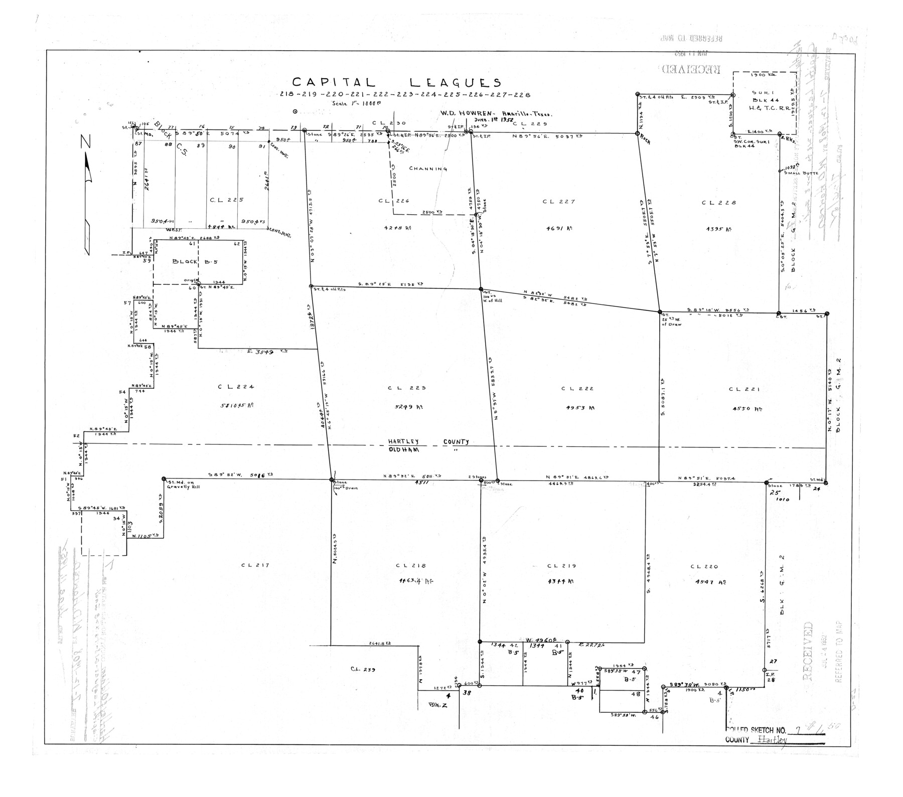
Hartley County Rolled Sketch 7
Capital Leagues 218, 219, 220, 221, 222, 223, 224, 225, 226, 227, 228
-
Map/Doc
6161
-
Collection
General Map Collection
-
Object Dates
1952/6/1 (Creation Date)
1952/7/24 (File Date)
-
People and Organizations
W.D. Howren (Surveyor/Engineer)
-
Counties
Hartley Oldham
-
Subjects
Surveying Rolled Sketch
-
Height x Width
24.2 x 27.4 inches
61.5 x 69.6 cm
-
Scale
1" = 1000 varas
Part of: General Map Collection
La Salle County Sketch File 5

Print $2.00
- Digital $50.00
La Salle County Sketch File 5
Size 6.9 x 8.9 inches
Map/Doc 29452
Coleman County Sketch File 24

Print $6.00
- Digital $50.00
Coleman County Sketch File 24
1872
Size 8.7 x 7.8 inches
Map/Doc 18705

Hopkins County Sketch File 7

Print $6.00
- Digital $50.00
Hopkins County Sketch File 7
Size 10.4 x 6.1 inches
Map/Doc 26692
McCulloch County Working Sketch 13

Print $20.00
- Digital $50.00
McCulloch County Working Sketch 13
1989
Size 36.7 x 33.3 inches
Map/Doc 70688
Hartley County Working Sketch Graphic Index

Print $40.00
- Digital $50.00
Hartley County Working Sketch Graphic Index
1925
Size 41.0 x 50.0 inches
Map/Doc 76571
Orange County Working Sketch 31

Print $20.00
- Digital $50.00
Orange County Working Sketch 31
1955
Size 24.2 x 13.8 inches
Map/Doc 71363
Gregg County Rolled Sketch MHH1

Print $40.00
- Digital $50.00
Gregg County Rolled Sketch MHH1
1935
Size 167.4 x 23.1 inches
Map/Doc 9064
Knox County Sketch File 29

Print $20.00
- Digital $50.00
Knox County Sketch File 29
Size 18.6 x 36.1 inches
Map/Doc 11965
Travis County

Print $40.00
- Digital $50.00
Travis County
1880
Size 59.0 x 70.2 inches
Map/Doc 16902
Lee County Rolled Sketch 2

Print $20.00
- Digital $50.00
Lee County Rolled Sketch 2
1976
Size 25.9 x 34.4 inches
Map/Doc 6593
Flight Mission No. CRC-4R, Frame 103, Chambers County

Print $20.00
- Digital $50.00
Flight Mission No. CRC-4R, Frame 103, Chambers County
1956
Size 18.4 x 22.3 inches
Map/Doc 84900
You may also like
Oldham County Boundary File 1d

Print $68.00
- Digital $50.00
Oldham County Boundary File 1d
Size 14.0 x 8.5 inches
Map/Doc 57759
Orange County Sketch File 1

Print $6.00
- Digital $50.00
Orange County Sketch File 1
Size 9.6 x 11.5 inches
Map/Doc 33299
Henderson County

Print $40.00
- Digital $50.00
Henderson County
1922
Size 32.9 x 62.6 inches
Map/Doc 66862
Carte de la Louisiane et du Cours du Mississipi

Print $20.00
- Digital $50.00
Carte de la Louisiane et du Cours du Mississipi
1718
Size 20.6 x 27.3 inches
Map/Doc 93821
Flight Mission No. BRA-7M, Frame 125, Jefferson County

Print $20.00
- Digital $50.00
Flight Mission No. BRA-7M, Frame 125, Jefferson County
1953
Size 16.3 x 16.1 inches
Map/Doc 85519
The Chief Justice County of Brazoria. April 24, 1837

Print $20.00
The Chief Justice County of Brazoria. April 24, 1837
2020
Size 14.8 x 21.7 inches
Map/Doc 96042
Lee County Boundary File 2

Print $25.00
- Digital $50.00
Lee County Boundary File 2
Size 14.2 x 8.6 inches
Map/Doc 56269
Andrews County Rolled Sketch 11

Print $20.00
- Digital $50.00
Andrews County Rolled Sketch 11
1933
Size 28.0 x 37.7 inches
Map/Doc 77161
United States of America compiled from the latest & best Authorities

Print $20.00
- Digital $50.00
United States of America compiled from the latest & best Authorities
1818
Size 17.3 x 20.9 inches
Map/Doc 97135

Stephens County Boundary File 4

Print $6.00
- Digital $50.00
Stephens County Boundary File 4
Size 14.3 x 8.8 inches
Map/Doc 58894
San Patricio County Sketch File 10

Print $8.00
San Patricio County Sketch File 10
1847
Size 13.3 x 8.4 inches
Map/Doc 36040