San Patricio County Sketch File 10
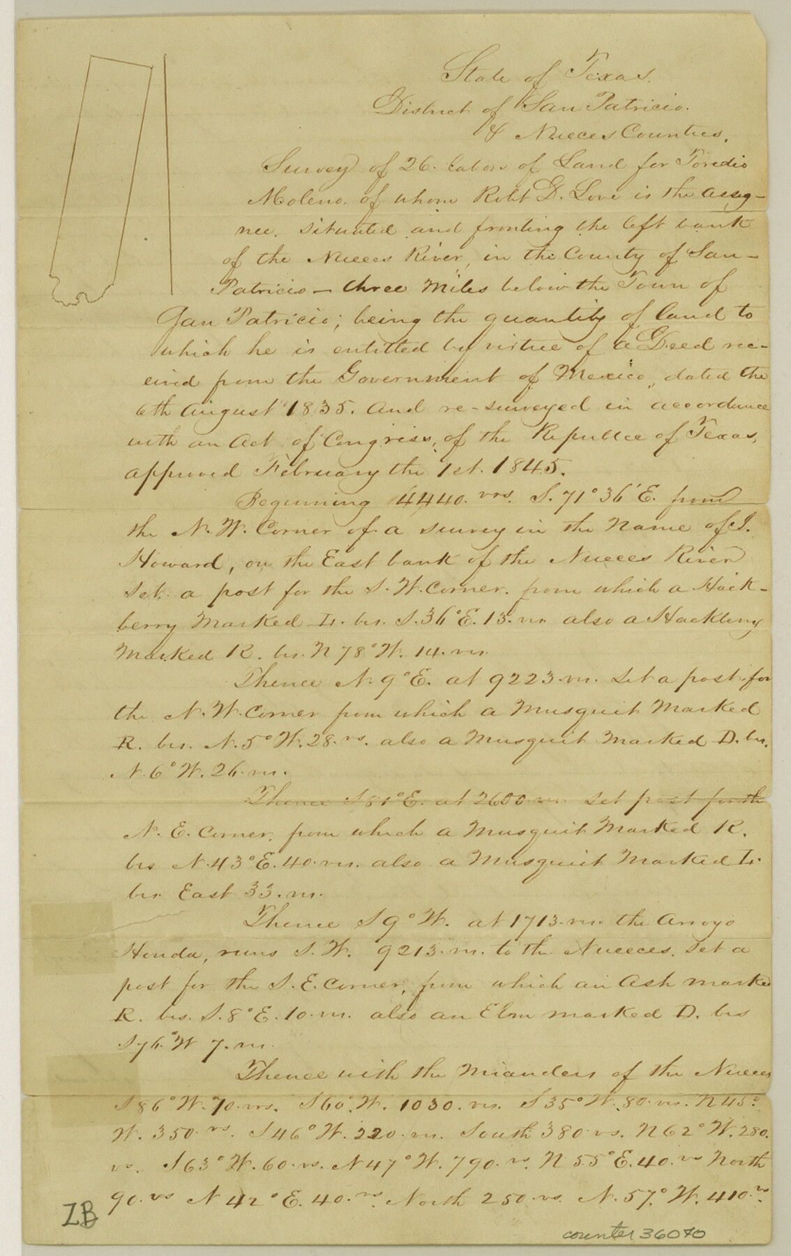
[Field notes of a resurvey of 1 league and 1 labor of land titled to Toribio Molina]
-
Map/Doc
36040
-
Collection
General Map Collection
-
Object Dates
1/16/1847 (Survey Date)
1/22/1847 (Creation Date)
-
People and Organizations
J. Snively (Surveyor/Engineer)
B.M. Carr (Chainman/Field Personnel)
John Annis (Chainman/Field Personnel)
-
Counties
San Patricio
-
Subjects
Surveying Sketch File
-
Height x Width
13.3 x 8.4 inches
33.8 x 21.3 cm
-
Medium
paper, manuscript
-
Features
Nueces River
Part of: General Map Collection
Newton County Rolled Sketch 27

Print $20.00
- Digital $50.00
Newton County Rolled Sketch 27
1961
Size 36.0 x 27.3 inches
Map/Doc 6856
Hudspeth County Working Sketch 23

Print $40.00
- Digital $50.00
Hudspeth County Working Sketch 23
1967
Size 52.6 x 39.2 inches
Map/Doc 66305
Harris County Sketch File 46

Print $6.00
- Digital $50.00
Harris County Sketch File 46
1906
Size 8.8 x 13.7 inches
Map/Doc 25443

Hudspeth County Rolled Sketch 18

Print $40.00
- Digital $50.00
Hudspeth County Rolled Sketch 18
1886
Size 15.7 x 105.0 inches
Map/Doc 9204
Val Verde County Working Sketch 39

Print $20.00
- Digital $50.00
Val Verde County Working Sketch 39
1943
Size 26.0 x 26.5 inches
Map/Doc 72174

Pecos County Rolled Sketch 133

Print $40.00
- Digital $50.00
Pecos County Rolled Sketch 133
1952
Size 50.8 x 12.1 inches
Map/Doc 9729
Flight Mission No. CGI-3N, Frame 125, Cameron County

Print $20.00
- Digital $50.00
Flight Mission No. CGI-3N, Frame 125, Cameron County
1954
Size 18.6 x 22.2 inches
Map/Doc 84598
Flight Mission No. DAG-17K, Frame 78, Matagorda County

Print $20.00
- Digital $50.00
Flight Mission No. DAG-17K, Frame 78, Matagorda County
1952
Size 18.7 x 22.4 inches
Map/Doc 86337
Brewster County Rolled Sketch 114

Print $20.00
- Digital $50.00
Brewster County Rolled Sketch 114
1964
Size 12.0 x 17.5 inches
Map/Doc 5291
Comanche County Sketch File 8

Print $4.00
- Digital $50.00
Comanche County Sketch File 8
1853
Size 13.1 x 8.2 inches
Map/Doc 19066
You may also like
North Line of Lynn County and South Line of Lubbock County

Print $20.00
- Digital $50.00
North Line of Lynn County and South Line of Lubbock County
1892
Size 8.0 x 34.2 inches
Map/Doc 91393
Mitchell County

Print $20.00
- Digital $50.00
Mitchell County
1889
Size 42.3 x 35.7 inches
Map/Doc 10792
Chambers County Sketch File B

Print $2.00
- Digital $50.00
Chambers County Sketch File B
1907
Size 7.2 x 8.5 inches
Map/Doc 17515
Map Showing Location of Galveston, Harrisburg & San Antonio Railway

Print $40.00
- Digital $50.00
Map Showing Location of Galveston, Harrisburg & San Antonio Railway
1881
Size 17.4 x 59.3 inches
Map/Doc 64457
Coke County Working Sketch Graphic Index

Print $20.00
- Digital $50.00
Coke County Working Sketch Graphic Index
1945
Size 38.9 x 41.5 inches
Map/Doc 76496
Map of Presidio County

Print $40.00
- Digital $50.00
Map of Presidio County
1895
Size 53.0 x 38.6 inches
Map/Doc 3968
[I. Killough and Hiram Cates surveys and vicinity]
![91845, [I. Killough and Hiram Cates surveys and vicinity], Twichell Survey Records](https://historictexasmaps.com/wmedia_w700/maps/91845-1.tif.jpg)
Print $3.00
- Digital $50.00
[I. Killough and Hiram Cates surveys and vicinity]
Size 16.9 x 10.5 inches
Map/Doc 91845
Live Oak County Sketch File 22

Print $20.00
- Digital $50.00
Live Oak County Sketch File 22
Size 17.4 x 9.7 inches
Map/Doc 30299
Glasscock County Rolled Sketch 16

Print $40.00
- Digital $50.00
Glasscock County Rolled Sketch 16
1986
Size 63.3 x 46.1 inches
Map/Doc 9060
Goliad County Sketch File 18

Print $100.00
- Digital $50.00
Goliad County Sketch File 18
1854
Size 12.8 x 15.5 inches
Map/Doc 24255
Dallam County

Print $20.00
- Digital $50.00
Dallam County
1926
Size 34.0 x 41.0 inches
Map/Doc 77257
Presidio County Rolled Sketch 116

Print $20.00
- Digital $50.00
Presidio County Rolled Sketch 116
1981
Size 30.9 x 25.0 inches
Map/Doc 9795