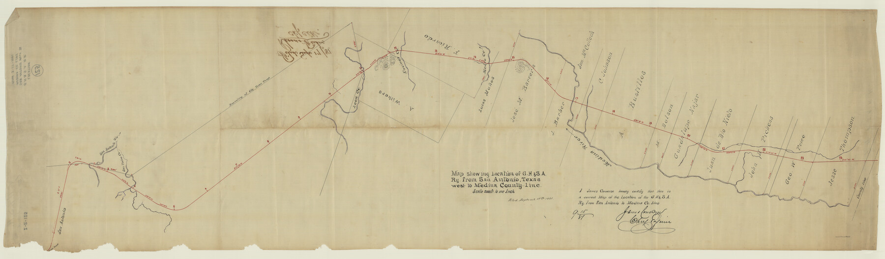
Map Showing Location of Galveston, Harrisburg & San Antonio Railway
Z-2-125
-
Map/Doc
64457
-
Collection
General Map Collection
-
Object Dates
1881 (Creation Date)
1881/9/17 (File Date)
-
Counties
Bexar
-
Subjects
Railroads
-
Height x Width
17.4 x 59.3 inches
44.2 x 150.6 cm
-
Medium
paper, manuscript
-
Scale
2000 ft. to 1 in.
-
Comments
From San Antonio, Texas West to Medina County line.
-
Features
GH&SA
San Antonio
San Antonio River
San Pedro Creek
Leon Creek
Encinos Creek
Medio Creek
Medina River
Part of: General Map Collection
Brown County Sketch File 8

Print $4.00
- Digital $50.00
Brown County Sketch File 8
1860
Size 13.4 x 8.1 inches
Map/Doc 16593
Fractional Township No. 10 South Range No. 2 East of the Indian Meridian, Indian Territory

Print $20.00
- Digital $50.00
Fractional Township No. 10 South Range No. 2 East of the Indian Meridian, Indian Territory
1898
Size 19.2 x 24.4 inches
Map/Doc 75202
Newton County Rolled Sketch 27

Print $20.00
- Digital $50.00
Newton County Rolled Sketch 27
1961
Size 36.0 x 27.3 inches
Map/Doc 6856
Fannin County Sketch File 16

Print $4.00
- Digital $50.00
Fannin County Sketch File 16
1873
Size 8.1 x 10.3 inches
Map/Doc 22469
Scurry County Rolled Sketch 6

Print $20.00
- Digital $50.00
Scurry County Rolled Sketch 6
1944
Size 29.0 x 28.8 inches
Map/Doc 7766
Reagan County

Print $20.00
- Digital $50.00
Reagan County
1940
Size 41.6 x 31.4 inches
Map/Doc 77403
Oldham County Rolled Sketch 10

Print $20.00
- Digital $50.00
Oldham County Rolled Sketch 10
Size 22.0 x 13.3 inches
Map/Doc 7176
Brazoria County NRC Article 33.136 Sketch 10

Print $23.00
- Digital $50.00
Brazoria County NRC Article 33.136 Sketch 10
2007
Size 25.7 x 35.7 inches
Map/Doc 87933
Cameron County Rolled Sketch 20C

Print $20.00
- Digital $50.00
Cameron County Rolled Sketch 20C
Size 13.1 x 11.9 inches
Map/Doc 5475
Hopkins County Sketch File 8

Print $6.00
- Digital $50.00
Hopkins County Sketch File 8
1856
Size 11.8 x 8.6 inches
Map/Doc 26695
Flight Mission No. BQY-4M, Frame 67, Harris County

Print $20.00
- Digital $50.00
Flight Mission No. BQY-4M, Frame 67, Harris County
1953
Size 18.7 x 22.4 inches
Map/Doc 85276
Hood County Working Sketch 23

Print $20.00
- Digital $50.00
Hood County Working Sketch 23
1993
Size 23.6 x 32.9 inches
Map/Doc 66217
You may also like
Stephens County

Print $20.00
- Digital $50.00
Stephens County
1879
Size 27.8 x 19.6 inches
Map/Doc 4051
Terrell County Sketch File 1

Print $78.00
- Digital $50.00
Terrell County Sketch File 1
1881
Size 9.1 x 8.8 inches
Map/Doc 37870
Houston County Rolled Sketch 8

Print $20.00
- Digital $50.00
Houston County Rolled Sketch 8
1948
Size 27.7 x 20.3 inches
Map/Doc 6228
Duval County Rolled Sketch 48

Print $20.00
- Digital $50.00
Duval County Rolled Sketch 48
Size 21.8 x 18.5 inches
Map/Doc 5762
Plat of Fee Land Adjoining the Town of Lovington, New Mexico

Print $20.00
- Digital $50.00
Plat of Fee Land Adjoining the Town of Lovington, New Mexico
Size 24.2 x 18.4 inches
Map/Doc 92422
Map of the Missouri Pacific and St. Louis, Iron Mountain and Southern Railways and Connections

Print $20.00
- Digital $50.00
Map of the Missouri Pacific and St. Louis, Iron Mountain and Southern Railways and Connections
1893
Size 17.7 x 31.6 inches
Map/Doc 95789
Terry County Working Sketch 2

Print $20.00
- Digital $50.00
Terry County Working Sketch 2
1952
Size 19.3 x 19.3 inches
Map/Doc 62107
Travis County Appraisal District Plat Map 1_0100

Print $20.00
- Digital $50.00
Travis County Appraisal District Plat Map 1_0100
Size 21.6 x 26.4 inches
Map/Doc 94205
General Highway Map, Hidalgo County, Texas

Print $20.00
General Highway Map, Hidalgo County, Texas
1961
Size 18.2 x 24.8 inches
Map/Doc 79519
Dickens County Sketch File H

Print $28.00
- Digital $50.00
Dickens County Sketch File H
Size 13.2 x 8.9 inches
Map/Doc 20861
Flight Mission No. BRE-1P, Frame 46, Nueces County

Print $20.00
- Digital $50.00
Flight Mission No. BRE-1P, Frame 46, Nueces County
1956
Size 16.4 x 16.2 inches
Map/Doc 86635
Red River County Working Sketch 17

Print $20.00
- Digital $50.00
Red River County Working Sketch 17
1954
Size 23.2 x 18.8 inches
Map/Doc 72000