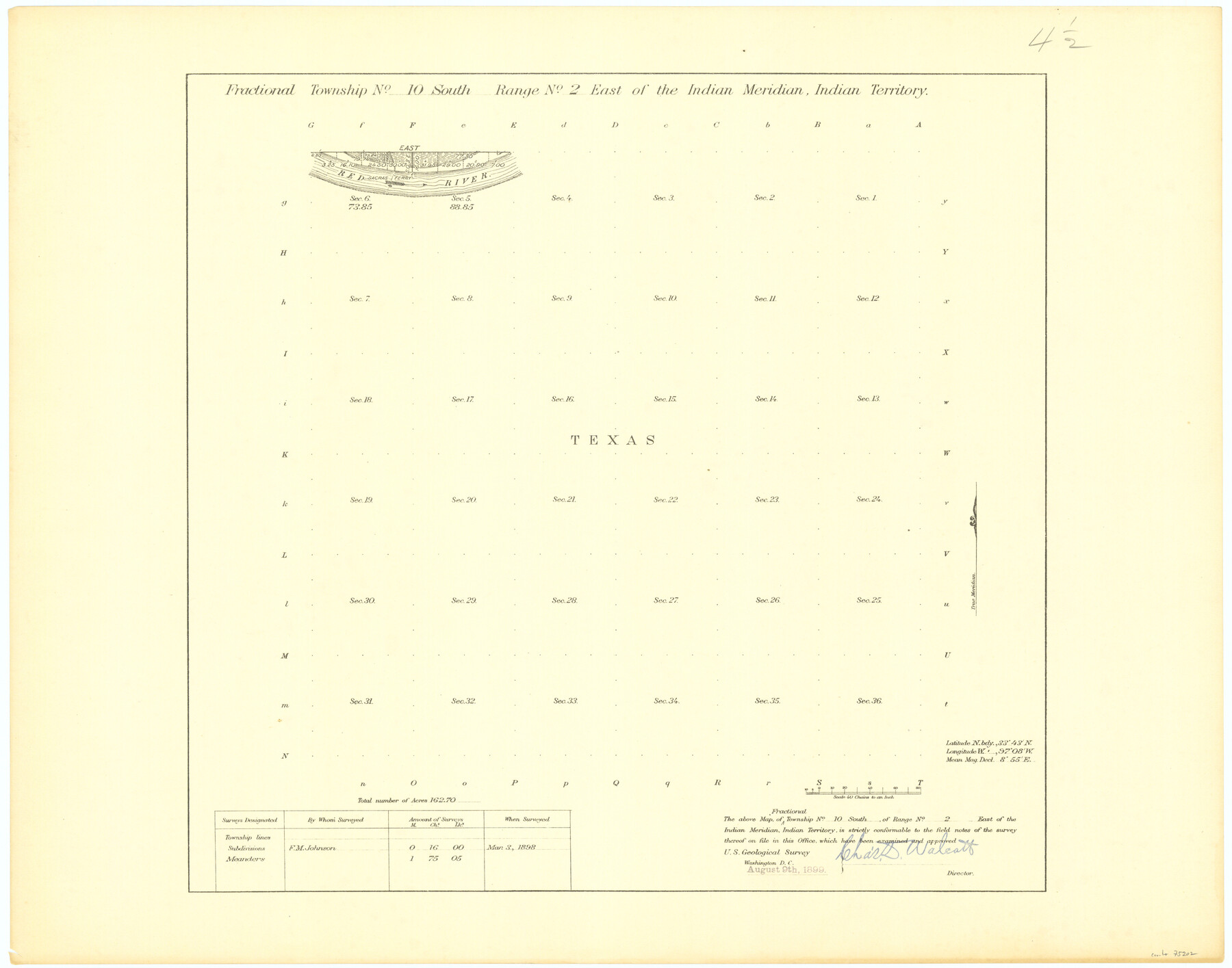
Fractional Township No. 10 South Range No. 2 East of the Indian Meridian, Indian Territory
-
Map/Doc
75202
-
Collection
General Map Collection
-
Object Dates
1898/3/3 (Creation Date)
-
Subjects
Texas Boundaries
-
Height x Width
19.2 x 24.4 inches
48.8 x 62.0 cm
Part of: General Map Collection
Webb County Working Sketch 11

Print $20.00
- Digital $50.00
Webb County Working Sketch 11
1921
Size 17.8 x 16.3 inches
Map/Doc 72376

Howard County Rolled Sketch 9

Print $20.00
- Digital $50.00
Howard County Rolled Sketch 9
1940
Size 35.2 x 26.9 inches
Map/Doc 6239
Harris County State Real Property Sketch 2

Print $32.00
- Digital $50.00
Harris County State Real Property Sketch 2
1999
Size 30.2 x 42.4 inches
Map/Doc 61702
Val Verde County Working Sketch 58

Print $20.00
- Digital $50.00
Val Verde County Working Sketch 58
1958
Size 21.0 x 22.8 inches
Map/Doc 72193
Van Zandt County Working Sketch 3

Print $20.00
- Digital $50.00
Van Zandt County Working Sketch 3
1923
Size 20.1 x 16.4 inches
Map/Doc 72252
[Sketch for Mineral Application 19560 - 19588 - San Bernard River]
![65580, [Sketch for Mineral Application 19560 - 19588 - San Bernard River], General Map Collection](https://historictexasmaps.com/wmedia_w700/maps/65580.tif.jpg)
Print $40.00
- Digital $50.00
[Sketch for Mineral Application 19560 - 19588 - San Bernard River]
1928
Size 98.2 x 33.1 inches
Map/Doc 65580
Newton County Rolled Sketch 14

Print $40.00
- Digital $50.00
Newton County Rolled Sketch 14
1953
Size 33.4 x 56.0 inches
Map/Doc 9579
[Map of the Stockdale-Cuero Extension G.H. & S.A. Ry.]
![64095, [Map of the Stockdale-Cuero Extension G.H. & S.A. Ry.], General Map Collection](https://historictexasmaps.com/wmedia_w700/maps/64095.tif.jpg)
Print $40.00
- Digital $50.00
[Map of the Stockdale-Cuero Extension G.H. & S.A. Ry.]
1905
Size 19.6 x 128.0 inches
Map/Doc 64095
Jefferson County Rolled Sketch 8

Print $54.00
- Digital $50.00
Jefferson County Rolled Sketch 8
1928
Size 36.0 x 46.6 inches
Map/Doc 9273
Hartley County

Print $40.00
- Digital $50.00
Hartley County
1925
Size 41.1 x 48.5 inches
Map/Doc 73174
Uvalde County Sketch File 16

Print $14.00
- Digital $50.00
Uvalde County Sketch File 16
1876
Size 12.8 x 8.4 inches
Map/Doc 38988
You may also like
Motley County Sketch File 17 (S)

Print $6.00
- Digital $50.00
Motley County Sketch File 17 (S)
1901
Size 14.2 x 8.7 inches
Map/Doc 32189
Crane County Sketch File 27

Print $6.00
- Digital $50.00
Crane County Sketch File 27
Size 11.5 x 9.3 inches
Map/Doc 19603
General Highway Map, Lamar County, Texas

Print $20.00
General Highway Map, Lamar County, Texas
1961
Size 24.6 x 18.2 inches
Map/Doc 79561
Brazoria County Sketch File 53

Print $14.00
- Digital $50.00
Brazoria County Sketch File 53
1919
Size 14.2 x 8.6 inches
Map/Doc 15316
Upshur County Working Sketch 15b

Print $20.00
- Digital $50.00
Upshur County Working Sketch 15b
1996
Size 36.7 x 29.4 inches
Map/Doc 69572
Webb County Working Sketch 31

Print $20.00
- Digital $50.00
Webb County Working Sketch 31
1937
Size 23.2 x 26.0 inches
Map/Doc 72396
Dawson County Sketch File 3a

Print $12.00
- Digital $50.00
Dawson County Sketch File 3a
Size 12.9 x 8.3 inches
Map/Doc 20503
General Highway Map, Mitchell County, Texas

Print $20.00
General Highway Map, Mitchell County, Texas
1961
Size 18.1 x 24.6 inches
Map/Doc 79600
Newton County Working Sketch 21

Print $20.00
- Digital $50.00
Newton County Working Sketch 21
1952
Size 27.5 x 32.5 inches
Map/Doc 71267

Map of Burleson County

Print $20.00
- Digital $50.00
Map of Burleson County
1856
Size 22.0 x 31.5 inches
Map/Doc 3345
Jasper County Rolled Sketch 5

Print $20.00
- Digital $50.00
Jasper County Rolled Sketch 5
1948
Size 29.0 x 24.4 inches
Map/Doc 6352