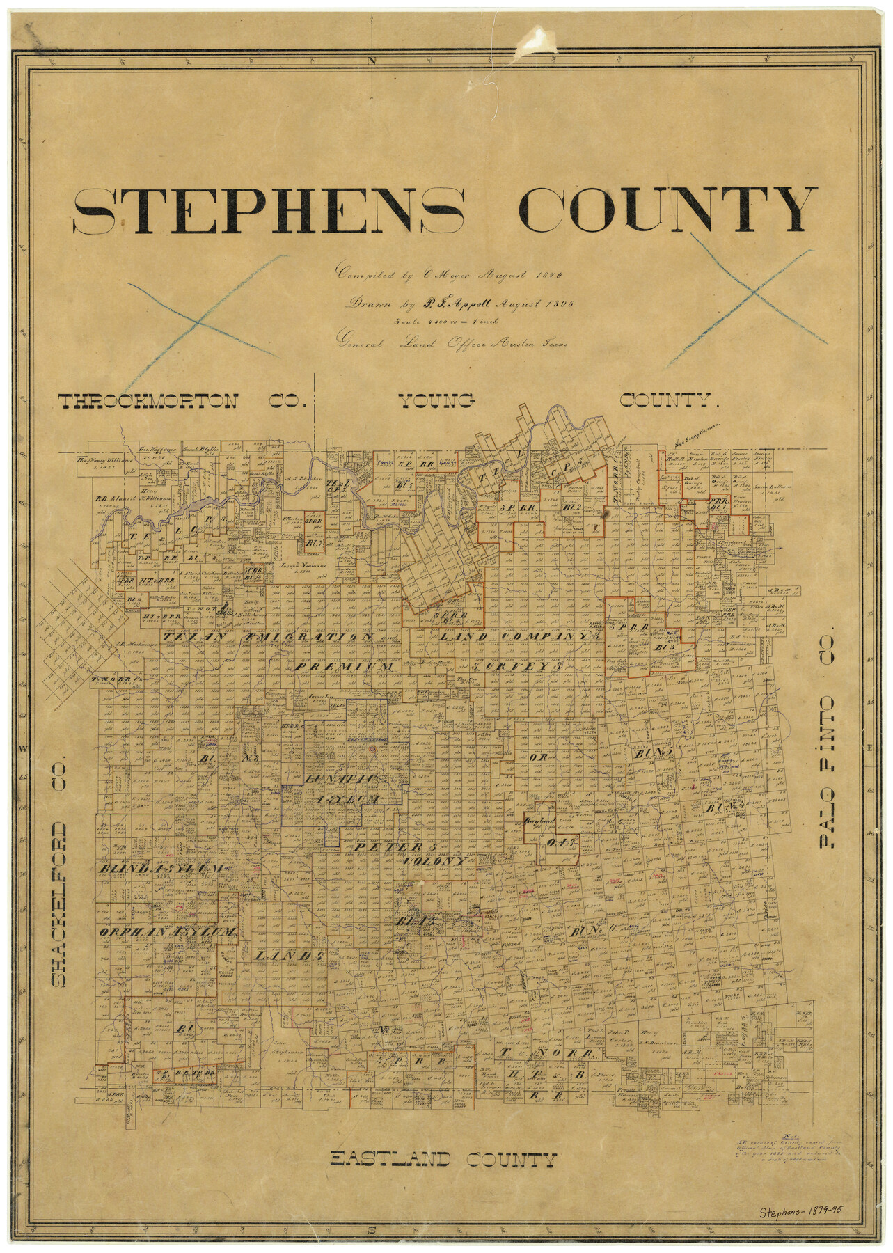
Stephens County
-
Map/Doc
4051
-
Collection
General Map Collection
-
Object Dates
8/1879 (Creation Date)
-
People and Organizations
Texas General Land Office (Publisher)
C. Meyer (Compiler)
P.F. Appell (Draftsman)
-
Counties
Stephens
-
Subjects
County
-
Height x Width
27.8 x 19.6 inches
70.6 x 49.8 cm
-
Comments
Compiled by C. Meyer, August 1879; drawn by P. F. Appell, August 1895.
-
Features
Sink Creek
Brazos River
Breckenridge
Hubbard Creek
Part of: General Map Collection
Flight Mission No. CLL-1N, Frame 88, Willacy County

Print $20.00
- Digital $50.00
Flight Mission No. CLL-1N, Frame 88, Willacy County
1954
Size 18.4 x 22.1 inches
Map/Doc 87034
Reagan County Rolled Sketch 29A

Print $20.00
- Digital $50.00
Reagan County Rolled Sketch 29A
1954
Size 36.4 x 36.3 inches
Map/Doc 9825
Borden County Boundary File 2

Print $22.00
- Digital $50.00
Borden County Boundary File 2
Size 13.6 x 8.7 inches
Map/Doc 50614
Lampasas County Working Sketch 18

Print $20.00
- Digital $50.00
Lampasas County Working Sketch 18
1977
Size 46.1 x 44.0 inches
Map/Doc 70295
Harris County Sketch File 94

Print $20.00
- Digital $50.00
Harris County Sketch File 94
1952
Size 33.9 x 17.4 inches
Map/Doc 11677
Frio County Sketch File 10

Print $20.00
- Digital $50.00
Frio County Sketch File 10
1906
Size 19.3 x 23.2 inches
Map/Doc 11518
Flight Mission No. CRC-6R, Frame 13, Chambers County

Print $20.00
- Digital $50.00
Flight Mission No. CRC-6R, Frame 13, Chambers County
1956
Size 18.6 x 22.3 inches
Map/Doc 84967
Calcasieu Pass to Sabine Pass

Print $20.00
- Digital $50.00
Calcasieu Pass to Sabine Pass
1950
Size 44.8 x 35.4 inches
Map/Doc 69808
Hardin County Working Sketch 14

Print $20.00
- Digital $50.00
Hardin County Working Sketch 14
1936
Size 25.1 x 42.6 inches
Map/Doc 63412
Kenedy County Aerial Photograph Index Sheet 6

Print $20.00
- Digital $50.00
Kenedy County Aerial Photograph Index Sheet 6
1943
Size 23.4 x 18.4 inches
Map/Doc 83716
Atascosa County Boundary File 5

Print $32.00
- Digital $50.00
Atascosa County Boundary File 5
Size 8.8 x 6.3 inches
Map/Doc 50198
Throckmorton Co.

Print $20.00
- Digital $50.00
Throckmorton Co.
1898
Size 41.2 x 35.9 inches
Map/Doc 16895
You may also like
Austin Map and Street Guide [Recto]
![94162, Austin Map and Street Guide [Recto], General Map Collection](https://historictexasmaps.com/wmedia_w700/maps/94162.tif.jpg)
Austin Map and Street Guide [Recto]
1976
Size 35.4 x 22.7 inches
Map/Doc 94162
Presidio County Rolled Sketch 104

Print $20.00
- Digital $50.00
Presidio County Rolled Sketch 104
1948
Size 26.1 x 40.0 inches
Map/Doc 7386
Map of survey of a part of Padre and Mustang Islands made for the Office of the Attorney General of the State of Texas

Print $20.00
- Digital $50.00
Map of survey of a part of Padre and Mustang Islands made for the Office of the Attorney General of the State of Texas
1941
Size 40.8 x 39.5 inches
Map/Doc 2257
Kerr County Sketch File 23

Print $8.00
- Digital $50.00
Kerr County Sketch File 23
1959
Size 14.2 x 8.8 inches
Map/Doc 28901
Glasscock County Rolled Sketch 15

Print $20.00
- Digital $50.00
Glasscock County Rolled Sketch 15
1964
Size 36.5 x 35.8 inches
Map/Doc 9059
Bowles's New Pocket Map of North America, divided into it's Provinces, Colonies, &c.

Print $20.00
- Digital $50.00
Bowles's New Pocket Map of North America, divided into it's Provinces, Colonies, &c.
1776
Size 21.8 x 29.0 inches
Map/Doc 93732
[Beaumont, Sour Lake and Western Ry. Right of Way and Alignment - Frisco]
![64122, [Beaumont, Sour Lake and Western Ry. Right of Way and Alignment - Frisco], General Map Collection](https://historictexasmaps.com/wmedia_w700/maps/64122.tif.jpg)
Print $20.00
- Digital $50.00
[Beaumont, Sour Lake and Western Ry. Right of Way and Alignment - Frisco]
1910
Size 19.8 x 45.9 inches
Map/Doc 64122
Anderson County Boundary File 4

Print $10.00
- Digital $50.00
Anderson County Boundary File 4
Size 8.9 x 7.4 inches
Map/Doc 49737
Sutton County Sketch File E2

Print $20.00
- Digital $50.00
Sutton County Sketch File E2
Size 16.8 x 19.0 inches
Map/Doc 12397
Wood County Boundary File 2

Print $8.00
- Digital $50.00
Wood County Boundary File 2
Size 8.4 x 7.1 inches
Map/Doc 60155
Gillespie County Working Sketch 3

Print $20.00
- Digital $50.00
Gillespie County Working Sketch 3
1960
Size 23.0 x 21.7 inches
Map/Doc 63166
Hemphill County

Print $20.00
- Digital $50.00
Hemphill County
1878
Size 19.1 x 16.9 inches
Map/Doc 3661