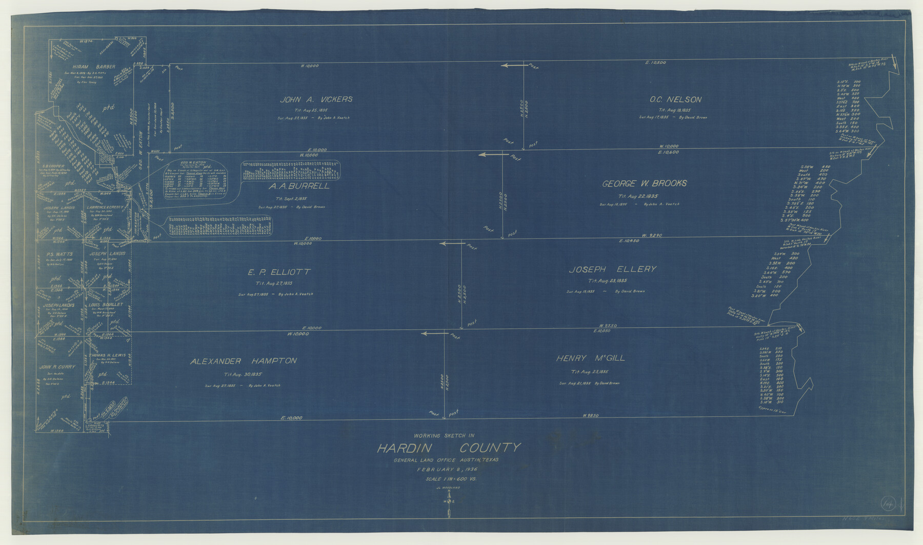
Hardin County Working Sketch 14
-
Map/Doc
63412
-
Collection
General Map Collection
-
Object Dates
2/8/1936 (Creation Date)
-
People and Organizations
J.L. Woodland (Draftsman)
-
Counties
Hardin
-
Subjects
Surveying Working Sketch
-
Height x Width
25.1 x 42.6 inches
63.8 x 108.2 cm
-
Scale
1" = 600 varas
Part of: General Map Collection
Upton County Working Sketch 36

Print $40.00
- Digital $50.00
Upton County Working Sketch 36
1957
Size 43.5 x 57.3 inches
Map/Doc 69532
Van Zandt County

Print $20.00
- Digital $50.00
Van Zandt County
1921
Size 46.7 x 41.4 inches
Map/Doc 63104
Kent County Working Sketch 20

Print $40.00
- Digital $50.00
Kent County Working Sketch 20
1980
Size 50.7 x 44.1 inches
Map/Doc 70027
Medina County Sketch File 8

Print $4.00
- Digital $50.00
Medina County Sketch File 8
Size 9.3 x 6.6 inches
Map/Doc 31456
El Paso County Rolled Sketch 52

Print $20.00
- Digital $50.00
El Paso County Rolled Sketch 52
1955
Size 18.5 x 24.3 inches
Map/Doc 5840
Duval County Sketch File 76

Print $20.00
- Digital $50.00
Duval County Sketch File 76
1959
Size 15.1 x 27.3 inches
Map/Doc 11410
Presidio County Rolled Sketch 21

Print $20.00
- Digital $50.00
Presidio County Rolled Sketch 21
1885
Size 35.5 x 42.8 inches
Map/Doc 9764

Cameron County Rolled Sketch 19

Print $2.00
- Digital $50.00
Cameron County Rolled Sketch 19
Size 7.1 x 5.7 inches
Map/Doc 5466
Wilbarger County Sketch File 18

Print $12.00
- Digital $50.00
Wilbarger County Sketch File 18
1886
Size 14.3 x 8.8 inches
Map/Doc 40209
Flight Mission No. DCL-7C, Frame 19, Kenedy County

Print $20.00
- Digital $50.00
Flight Mission No. DCL-7C, Frame 19, Kenedy County
1943
Size 15.4 x 15.2 inches
Map/Doc 86011
Williamson County Working Sketch 12

Print $20.00
- Digital $50.00
Williamson County Working Sketch 12
1977
Size 37.0 x 35.0 inches
Map/Doc 72572
You may also like
Webb County Working Sketch 94

Print $20.00
- Digital $50.00
Webb County Working Sketch 94
1989
Size 23.1 x 25.6 inches
Map/Doc 72461
Matagorda County

Print $20.00
- Digital $50.00
Matagorda County
1896
Size 32.7 x 30.5 inches
Map/Doc 5082
McMullen County Sketch File 42

Print $6.00
- Digital $50.00
McMullen County Sketch File 42
1941
Size 14.2 x 8.9 inches
Map/Doc 31418
Angelina County

Print $40.00
- Digital $50.00
Angelina County
1945
Size 39.0 x 48.4 inches
Map/Doc 73068
San Jacinto County

Print $20.00
- Digital $50.00
San Jacinto County
1942
Size 47.1 x 42.8 inches
Map/Doc 63017
Schleicher County Sketch File 18

Print $20.00
- Digital $50.00
Schleicher County Sketch File 18
Size 15.1 x 25.0 inches
Map/Doc 12300
[H. & T. C. Block 34 and PSL Block B-19]
![91948, [H. & T. C. Block 34 and PSL Block B-19], Twichell Survey Records](https://historictexasmaps.com/wmedia_w700/maps/91948-1.tif.jpg)
Print $20.00
- Digital $50.00
[H. & T. C. Block 34 and PSL Block B-19]
Size 30.6 x 30.6 inches
Map/Doc 91948
Western Hemisphere

Print $20.00
- Digital $50.00
Western Hemisphere
1885
Size 12.2 x 9.0 inches
Map/Doc 93510
Terry County Sketch File 19

Print $6.00
- Digital $50.00
Terry County Sketch File 19
1998
Size 11.2 x 8.9 inches
Map/Doc 38047

Culberson County Rolled Sketch 67

Print $20.00
- Digital $50.00
Culberson County Rolled Sketch 67
1969
Size 18.1 x 23.1 inches
Map/Doc 5785
Midland County, Texas

Print $20.00
- Digital $50.00
Midland County, Texas
1880
Size 25.5 x 21.5 inches
Map/Doc 740