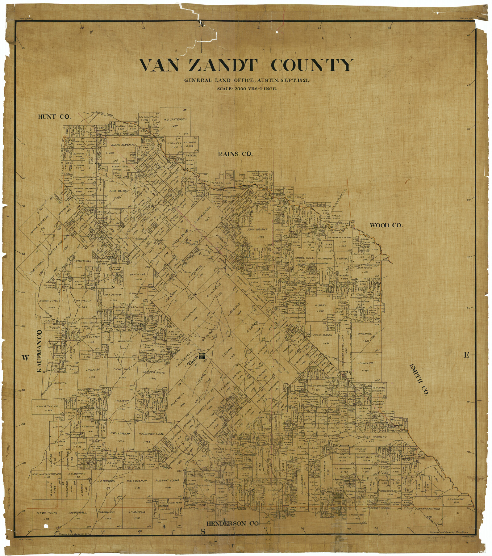
Van Zandt County
-
Map/Doc
63104
-
Collection
General Map Collection
-
Object Dates
9/1921 (Creation Date)
-
People and Organizations
Tom G. Atlee (Draftsman)
-
Counties
Van Zandt
-
Subjects
County
-
Height x Width
46.7 x 41.4 inches
118.6 x 105.2 cm
-
Comments
Traced by J. Bascom Giles.
Part of: General Map Collection
Flight Mission No. CRC-5R, Frame 35, Chambers County

Print $20.00
- Digital $50.00
Flight Mission No. CRC-5R, Frame 35, Chambers County
1956
Size 18.5 x 22.3 inches
Map/Doc 84954
Wharton County Rolled Sketch 12

Print $20.00
- Digital $50.00
Wharton County Rolled Sketch 12
1986
Size 31.1 x 23.7 inches
Map/Doc 8237
Flight Mission No. CRE-2R, Frame 157, Jackson County

Print $20.00
- Digital $50.00
Flight Mission No. CRE-2R, Frame 157, Jackson County
1956
Size 18.4 x 22.3 inches
Map/Doc 85368
Outer Continental Shelf Leasing Maps (Louisiana Offshore Operations)

Print $20.00
- Digital $50.00
Outer Continental Shelf Leasing Maps (Louisiana Offshore Operations)
1959
Size 17.9 x 13.8 inches
Map/Doc 76101
Runnels County Rolled Sketch A

Print $20.00
- Digital $50.00
Runnels County Rolled Sketch A
1891
Size 13.4 x 15.0 inches
Map/Doc 7539
Gaines County Rolled Sketch 11

Print $20.00
- Digital $50.00
Gaines County Rolled Sketch 11
1939
Size 22.4 x 32.9 inches
Map/Doc 5931
Baylor County Sketch File 11B

Print $20.00
- Digital $50.00
Baylor County Sketch File 11B
1892
Map/Doc 88490
Texas State Boundary Line 3

Print $90.00
- Digital $50.00
Texas State Boundary Line 3
Size 10.9 x 8.2 inches
Map/Doc 74904
Mills County Boundary File 8

Print $10.00
- Digital $50.00
Mills County Boundary File 8
Size 14.2 x 8.7 inches
Map/Doc 57313
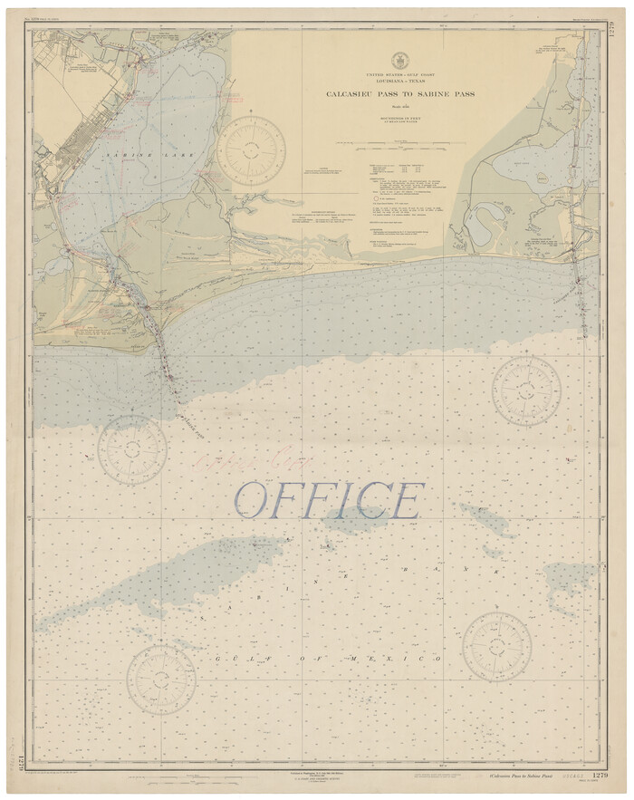
Calcasieu Pass to Sabine Pass
Print $20.00
- Digital $50.00
Calcasieu Pass to Sabine Pass
1946
Size 45.0 x 35.7 inches
Map/Doc 69807
Presidio County Working Sketch 24

Print $20.00
- Digital $50.00
Presidio County Working Sketch 24
1945
Size 18.0 x 11.9 inches
Map/Doc 71700
Wichita County

Print $20.00
- Digital $50.00
Wichita County
1924
Size 33.7 x 40.2 inches
Map/Doc 63123
You may also like
Castro County Sketch File 8

Print $20.00
- Digital $50.00
Castro County Sketch File 8
1908
Size 27.2 x 24.0 inches
Map/Doc 11060
[Sketch of part of Blks. B5, 6, 2Z, M6, M8, M11 and M15]
![89644, [Sketch of part of Blks. B5, 6, 2Z, M6, M8, M11 and M15], Twichell Survey Records](https://historictexasmaps.com/wmedia_w700/maps/89644-1.tif.jpg)
Print $40.00
- Digital $50.00
[Sketch of part of Blks. B5, 6, 2Z, M6, M8, M11 and M15]
Size 18.6 x 62.0 inches
Map/Doc 89644
Pecos County Rolled Sketch CM-2

Print $20.00
- Digital $50.00
Pecos County Rolled Sketch CM-2
1938
Size 33.6 x 41.3 inches
Map/Doc 9716
Acts of the Visit of the Royal Commissioners (sometimes referred to as the “Visita General”) - Camargo

Acts of the Visit of the Royal Commissioners (sometimes referred to as the “Visita General”) - Camargo
1767
Size 14.3 x 9.5 inches
Map/Doc 94254
Loving County Working Sketch 11

Print $40.00
- Digital $50.00
Loving County Working Sketch 11
1957
Size 21.6 x 50.9 inches
Map/Doc 70644
Nueces County Sketch File 17

Print $20.00
- Digital $50.00
Nueces County Sketch File 17
1854
Size 24.8 x 26.6 inches
Map/Doc 42180
Wharton County Sketch File 7

Print $4.00
- Digital $50.00
Wharton County Sketch File 7
1879
Size 7.7 x 9.7 inches
Map/Doc 39925
Nueces County Rolled Sketch 78

Print $53.00
Nueces County Rolled Sketch 78
1982
Size 18.2 x 24.9 inches
Map/Doc 6945
[S. M. Walker, D. P. Allen, J. C. Guinn, J. R. Lamar and surrounding surveys]
![90335, [S. M. Walker, D. P. Allen, J. C. Guinn, J. R. Lamar and surrounding surveys], Twichell Survey Records](https://historictexasmaps.com/wmedia_w700/maps/90335-1.tif.jpg)
Print $3.00
- Digital $50.00
[S. M. Walker, D. P. Allen, J. C. Guinn, J. R. Lamar and surrounding surveys]
1912
Size 9.8 x 11.3 inches
Map/Doc 90335
Northern Part of Laguna Madre

Print $20.00
- Digital $50.00
Northern Part of Laguna Madre
1935
Size 44.4 x 35.1 inches
Map/Doc 73522
Jasper County Working Sketch 19

Print $20.00
- Digital $50.00
Jasper County Working Sketch 19
1939
Size 15.8 x 15.8 inches
Map/Doc 66481
Crockett County Working Sketch 69

Print $20.00
- Digital $50.00
Crockett County Working Sketch 69
1962
Size 34.8 x 45.5 inches
Map/Doc 68402