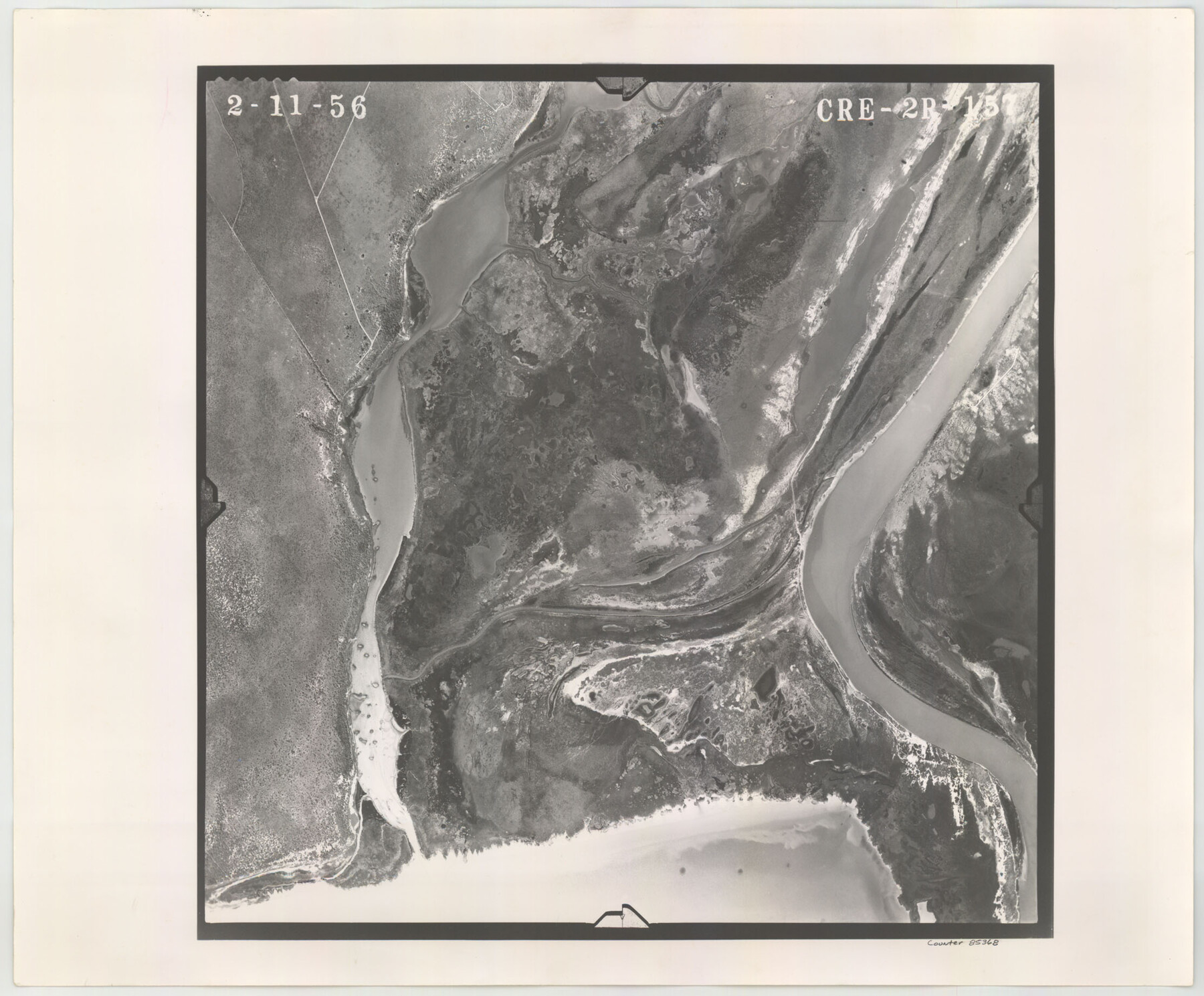
Flight Mission No. CRE-2R, Frame 157, Jackson County
CRE-2R-157
-
Map/Doc
85368
-
Collection
General Map Collection
-
Object Dates
1956/2/11 (Creation Date)
-
People and Organizations
U. S. Department of Agriculture (Publisher)
-
Counties
Jackson
-
Subjects
Aerial Photograph
-
Height x Width
18.4 x 22.3 inches
46.7 x 56.6 cm
-
Comments
Flown by Jack Ammann Photogrammetric Engineers of San Antonio, Texas.
Part of: General Map Collection
Coast Chart No. 105 - Galveston Bay to Oyster Bay, Texas

Print $20.00
- Digital $50.00
Coast Chart No. 105 - Galveston Bay to Oyster Bay, Texas
1884
Size 24.3 x 30.1 inches
Map/Doc 69925
Travis County Sketch File 38

Print $20.00
- Digital $50.00
Travis County Sketch File 38
1913
Size 16.6 x 17.4 inches
Map/Doc 12462
Scurry County Boundary File 1

Print $74.00
- Digital $50.00
Scurry County Boundary File 1
Size 9.2 x 3.8 inches
Map/Doc 58597
Flight Mission No. DAG-21K, Frame 89, Matagorda County

Print $20.00
- Digital $50.00
Flight Mission No. DAG-21K, Frame 89, Matagorda County
1952
Size 18.5 x 22.3 inches
Map/Doc 86418

Haskell County Boundary File 5

Print $80.00
- Digital $50.00
Haskell County Boundary File 5
Size 16.5 x 11.9 inches
Map/Doc 54578
Segunda parte del Mapa, que comprende la Frontera, de los Dominios del Rey, en la America Septentrional

Print $40.00
- Digital $50.00
Segunda parte del Mapa, que comprende la Frontera, de los Dominios del Rey, en la America Septentrional
1769
Size 26.7 x 63.8 inches
Map/Doc 4667
Medina County Working Sketch 14

Print $20.00
- Digital $50.00
Medina County Working Sketch 14
1972
Size 21.5 x 30.7 inches
Map/Doc 70929
Presidio County Working Sketch 81

Print $20.00
- Digital $50.00
Presidio County Working Sketch 81
1967
Size 18.9 x 17.4 inches
Map/Doc 71758
Colorado County Sketch File 15

Print $4.00
- Digital $50.00
Colorado County Sketch File 15
Size 13.0 x 8.1 inches
Map/Doc 18943
Smith County Working Sketch 16

Print $20.00
- Digital $50.00
Smith County Working Sketch 16
1988
Size 33.6 x 44.9 inches
Map/Doc 63901
[Surveys in Austin's Colony along Chocolate Bayou and Austin Bayou]
![192, [Surveys in Austin's Colony along Chocolate Bayou and Austin Bayou], General Map Collection](https://historictexasmaps.com/wmedia_w700/maps/192.tif.jpg)
Print $20.00
- Digital $50.00
[Surveys in Austin's Colony along Chocolate Bayou and Austin Bayou]
1830
Size 32.9 x 10.8 inches
Map/Doc 192
You may also like
From Citizens Living in Gonzales and Victoria Counties for the Creation of a New Judicial County to be Called Guadalupe, Undated

Print $20.00
From Citizens Living in Gonzales and Victoria Counties for the Creation of a New Judicial County to be Called Guadalupe, Undated
2020
Size 24.5 x 21.7 inches
Map/Doc 96413
Palo Pinto County Working Sketch 14

Print $20.00
- Digital $50.00
Palo Pinto County Working Sketch 14
1960
Size 27.2 x 27.4 inches
Map/Doc 71397
Coke County Sketch File 16

Print $20.00
- Digital $50.00
Coke County Sketch File 16
1902
Size 18.7 x 16.2 inches
Map/Doc 11108
Menard County Rolled Sketch 2A

Print $20.00
- Digital $50.00
Menard County Rolled Sketch 2A
1905
Size 23.3 x 18.5 inches
Map/Doc 6753
Andrews County Sketch File 5

Print $4.00
- Digital $50.00
Andrews County Sketch File 5
1936
Size 11.8 x 8.8 inches
Map/Doc 12823
Brown County State Real Property Sketch 1

Print $80.00
- Digital $50.00
Brown County State Real Property Sketch 1
2018
Size 48.0 x 36.0 inches
Map/Doc 95204
Bowie County Rolled Sketch 3

Print $57.00
- Digital $50.00
Bowie County Rolled Sketch 3
1970
Size 10.0 x 15.3 inches
Map/Doc 42739
Hardin County Sketch File 12

Print $4.00
- Digital $50.00
Hardin County Sketch File 12
Size 5.4 x 8.2 inches
Map/Doc 25116
Panola County Rolled Sketch 8

Print $20.00
- Digital $50.00
Panola County Rolled Sketch 8
1986
Size 20.1 x 18.0 inches
Map/Doc 7201
Township No. 5 South, Range No. 14 West, Indian Meridian, Oklahoma

Print $4.00
- Digital $50.00
Township No. 5 South, Range No. 14 West, Indian Meridian, Oklahoma
1928
Size 18.0 x 22.6 inches
Map/Doc 75141
Die Vereinigten Staaten von Nord-America

Print $20.00
- Digital $50.00
Die Vereinigten Staaten von Nord-America
1834
Size 23.5 x 28.1 inches
Map/Doc 93694
Trinity County Sketch File 13

Print $6.00
- Digital $50.00
Trinity County Sketch File 13
1857
Size 5.0 x 6.3 inches
Map/Doc 38537