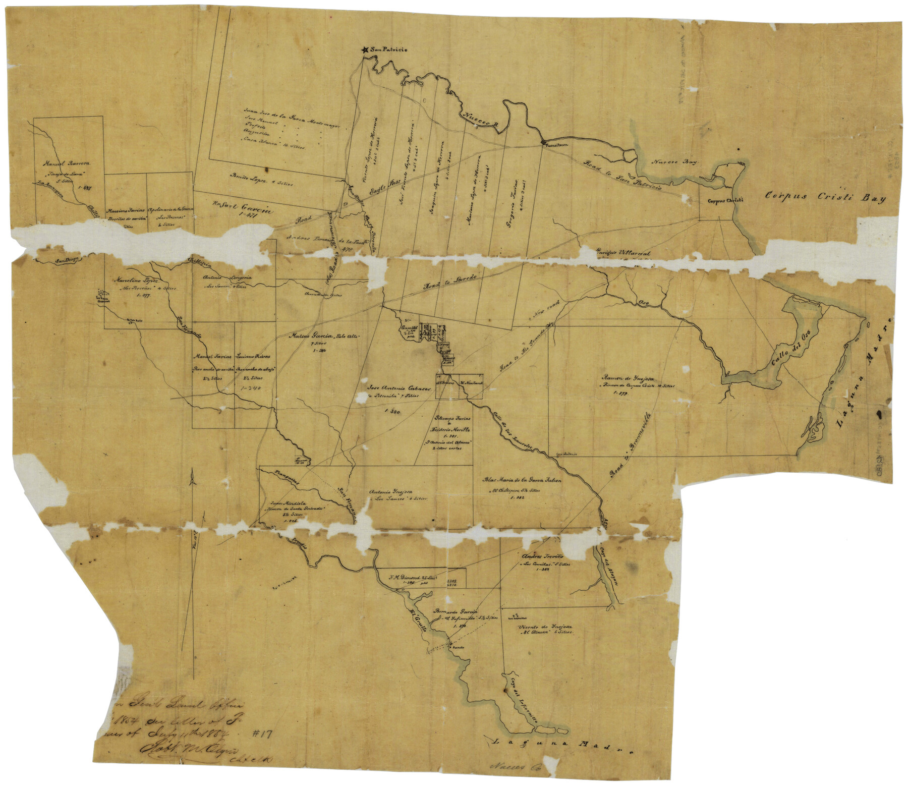
Nueces County Sketch File 17
[Sketch of Nueces County]
-
Map/Doc
42180
-
Collection
General Map Collection
-
Object Dates
7/11/1854 (Creation Date)
-
Counties
Nueces Kleberg Jim Wells
-
Subjects
Surveying Sketch File
-
Height x Width
24.8 x 26.6 inches
63.0 x 67.6 cm
-
Medium
paper, manuscript
-
Features
Road to Laredo
El Grullo
Laguna Madre
Cayo del Infiernillo
Agua de la Cayo del Atazan
San Fernando [Road]
Santa Gertrudis [Creek]
Tranquitas [Creek]
Callo de los Laureles
Road to Brownsville
Laguna Madre
Callo del Oso
Oso Creek
New Road
Road to Rio Grande City
San Patricio
Old Road to Brownsville
San Fernando [Creek]
San Diego [Creek]
La Amargosa [Creek]
Chiltipin Creek
Road to Eagle Pass
Santa Petronila [Creek]
Agua Dulce
Road to San Patricio
Corpus Christi
Corpus Christi Bay
Nueces Bay
Nuecestown
Nueces River
Part of: General Map Collection
Roberts County Rolled Sketch 6

Print $20.00
- Digital $50.00
Roberts County Rolled Sketch 6
2018
Map/Doc 97395
San Patricio County Sketch File 39

Print $8.00
- Digital $50.00
San Patricio County Sketch File 39
Size 12.9 x 8.4 inches
Map/Doc 36232
Childress County

Print $20.00
- Digital $50.00
Childress County
1921
Size 43.8 x 32.6 inches
Map/Doc 66753
Brazos River, Fresno Sheet

Print $20.00
- Digital $50.00
Brazos River, Fresno Sheet
1938
Size 31.3 x 38.4 inches
Map/Doc 65289
Street guide and metropolitan map of New Orleans [Recto]
![94198, Street guide and metropolitan map of New Orleans [Recto], General Map Collection](https://historictexasmaps.com/wmedia_w700/maps/94198.tif.jpg)
Street guide and metropolitan map of New Orleans [Recto]
1963
Size 18.3 x 27.2 inches
Map/Doc 94198
Hamilton County Boundary File 4

Print $60.00
- Digital $50.00
Hamilton County Boundary File 4
Size 9.2 x 8.1 inches
Map/Doc 54205
Presidio County Working Sketch 132

Print $20.00
- Digital $50.00
Presidio County Working Sketch 132
1989
Size 36.7 x 29.4 inches
Map/Doc 71810
Flight Mission No. DQN-2K, Frame 80, Calhoun County

Print $20.00
- Digital $50.00
Flight Mission No. DQN-2K, Frame 80, Calhoun County
1953
Size 18.4 x 22.2 inches
Map/Doc 84272
Cooke County Boundary File 1

Print $4.00
- Digital $50.00
Cooke County Boundary File 1
Size 12.6 x 7.5 inches
Map/Doc 51826
Presidio County Sketch File 28

Print $20.00
- Digital $50.00
Presidio County Sketch File 28
1890
Size 30.2 x 16.1 inches
Map/Doc 11709
Map of Mexico, including Yucatan & Upper California exhibiting the chief cities and towns, the principal travelling routes &c.

Print $20.00
- Digital $50.00
Map of Mexico, including Yucatan & Upper California exhibiting the chief cities and towns, the principal travelling routes &c.
1847
Size 21.9 x 29.6 inches
Map/Doc 94017
Webb County Sketch File 70

Print $26.00
- Digital $50.00
Webb County Sketch File 70
Size 11.4 x 8.9 inches
Map/Doc 39875
You may also like
Tom Green County Sketch File 13

Print $4.00
- Digital $50.00
Tom Green County Sketch File 13
Size 6.3 x 8.4 inches
Map/Doc 38170
[USGS Topo Quad map of Shafter Sheet, Presidio County]
![91754, [USGS Topo Quad map of Shafter Sheet, Presidio County], Twichell Survey Records](https://historictexasmaps.com/wmedia_w700/maps/91754-1.tif.jpg)
Print $20.00
- Digital $50.00
[USGS Topo Quad map of Shafter Sheet, Presidio County]
1895
Size 16.9 x 20.5 inches
Map/Doc 91754
Texas Gulf Coast Map from the Sabine River to the Rio Grande as subdivided for mineral development

Print $20.00
- Digital $50.00
Texas Gulf Coast Map from the Sabine River to the Rio Grande as subdivided for mineral development
1948
Size 41.6 x 39.2 inches
Map/Doc 2904
Kenedy County Sketch File 2

Print $130.00
- Digital $50.00
Kenedy County Sketch File 2
1995
Size 11.2 x 8.7 inches
Map/Doc 28773
El Paso County Sketch File 37

Print $4.00
- Digital $50.00
El Paso County Sketch File 37
1987
Size 14.4 x 9.1 inches
Map/Doc 22221
Andrews County Rolled Sketch 32

Print $20.00
- Digital $50.00
Andrews County Rolled Sketch 32
1950
Size 26.2 x 16.4 inches
Map/Doc 77176
Jeff Davis County Boundary File 1a

Print $8.00
- Digital $50.00
Jeff Davis County Boundary File 1a
Size 14.3 x 8.8 inches
Map/Doc 55501
Tom Green County Sketch File 41

Print $8.00
- Digital $50.00
Tom Green County Sketch File 41
1884
Size 12.8 x 8.3 inches
Map/Doc 38196
Cooke County Sketch File 29

Print $16.00
- Digital $50.00
Cooke County Sketch File 29
1873
Size 8.2 x 11.0 inches
Map/Doc 19283
A New Map of the United States upon which are delineated its vast works of internal communication, routes across the continent &c. showing also Canada and the Island of Cuba

Print $20.00
- Digital $50.00
A New Map of the United States upon which are delineated its vast works of internal communication, routes across the continent &c. showing also Canada and the Island of Cuba
Size 25.8 x 30.6 inches
Map/Doc 93996
[Capitol lands granted for purpose of building State Capitol]
![2073, [Capitol lands granted for purpose of building State Capitol], General Map Collection](https://historictexasmaps.com/wmedia_w700/maps/2073.tif.jpg)
Print $20.00
- Digital $50.00
[Capitol lands granted for purpose of building State Capitol]
1956
Size 31.5 x 13.0 inches
Map/Doc 2073
Garza County Sketch File E1

Print $8.00
- Digital $50.00
Garza County Sketch File E1
1901
Size 11.2 x 8.8 inches
Map/Doc 24022