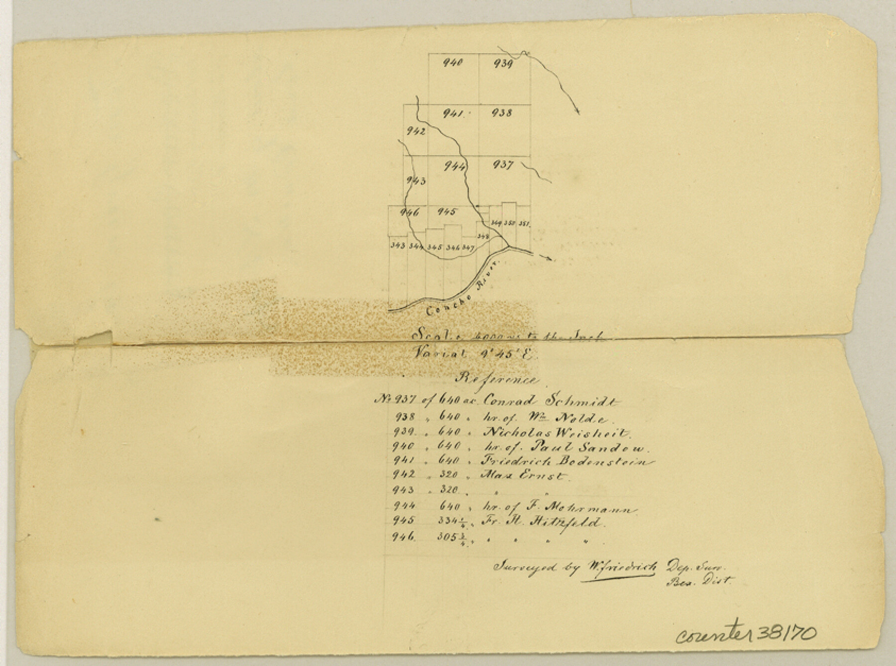
Tom Green County Sketch File 13
[Sketch of surveys on the north bank of the Concho River northeast from San Angelo]
-
Map/Doc
38170
-
Collection
General Map Collection
-
Object Dates
1/5/1858 (File Date)
-
People and Organizations
W. Friedrich (Surveyor/Engineer)
-
Counties
Tom Green
-
Subjects
Surveying Sketch File
-
Height x Width
6.3 x 8.4 inches
16.0 x 21.3 cm
-
Medium
paper, manuscript
-
Scale
1" = 4000 varas
-
Features
Concho River
Part of: General Map Collection
Flight Mission No. CLL-1N, Frame 88, Willacy County

Print $20.00
- Digital $50.00
Flight Mission No. CLL-1N, Frame 88, Willacy County
1954
Size 18.4 x 22.1 inches
Map/Doc 87034
Harris County Working Sketch 121

Print $20.00
- Digital $50.00
Harris County Working Sketch 121
1985
Size 34.4 x 18.6 inches
Map/Doc 66013
Jasper County Sketch File 33

Print $20.00
- Digital $50.00
Jasper County Sketch File 33
1938
Size 23.0 x 17.6 inches
Map/Doc 11854
Terry County Sketch File 3

Print $20.00
- Digital $50.00
Terry County Sketch File 3
1948
Size 16.2 x 39.0 inches
Map/Doc 10390
Collin County Boundary File 18b

Print $24.00
- Digital $50.00
Collin County Boundary File 18b
Size 12.7 x 8.1 inches
Map/Doc 51721
Fractional Township No. 8 South Range No. 19 East of the Indian Meridian, Indian Territory

Print $20.00
- Digital $50.00
Fractional Township No. 8 South Range No. 19 East of the Indian Meridian, Indian Territory
1897
Size 19.1 x 24.2 inches
Map/Doc 75234
Montague County Working Sketch 16

Print $20.00
- Digital $50.00
Montague County Working Sketch 16
1946
Size 44.1 x 40.8 inches
Map/Doc 71082
Gregg County Working Sketch 9

Print $20.00
- Digital $50.00
Gregg County Working Sketch 9
1939
Size 20.3 x 34.8 inches
Map/Doc 63275
Shackelford County Sketch File 3

Print $8.00
- Digital $50.00
Shackelford County Sketch File 3
1852
Size 8.2 x 7.3 inches
Map/Doc 36574
Menard County Rolled Sketch 6

Print $20.00
- Digital $50.00
Menard County Rolled Sketch 6
Size 17.3 x 21.2 inches
Map/Doc 6755
Cooke County Sketch File 8

Print $4.00
- Digital $50.00
Cooke County Sketch File 8
Size 8.2 x 8.4 inches
Map/Doc 19235
Midland County Rolled Sketch 1

Print $20.00
- Digital $50.00
Midland County Rolled Sketch 1
1940
Size 32.9 x 35.0 inches
Map/Doc 9512
You may also like
Flight Mission No. BRE-1P, Frame 139, Nueces County

Print $20.00
- Digital $50.00
Flight Mission No. BRE-1P, Frame 139, Nueces County
1956
Size 18.8 x 22.6 inches
Map/Doc 86699
Travis County

Print $40.00
- Digital $50.00
Travis County
1880
Size 62.1 x 50.2 inches
Map/Doc 87935
Reeves County Rolled Sketch 30

Print $20.00
- Digital $50.00
Reeves County Rolled Sketch 30
1988
Size 18.4 x 24.4 inches
Map/Doc 7499
Fort Bend County Boundary File 4

Print $40.00
- Digital $50.00
Fort Bend County Boundary File 4
Size 18.5 x 26.2 inches
Map/Doc 53567
Lamb County Sketch File 15

Print $6.00
- Digital $50.00
Lamb County Sketch File 15
Size 9.8 x 10.9 inches
Map/Doc 29377
[I. & G. N. Block 1]
![90343, [I. & G. N. Block 1], Twichell Survey Records](https://historictexasmaps.com/wmedia_w700/maps/90343-1.tif.jpg)
Print $20.00
- Digital $50.00
[I. & G. N. Block 1]
Size 13.1 x 18.1 inches
Map/Doc 90343
Presidio County Sketch File 32

Print $8.00
- Digital $50.00
Presidio County Sketch File 32
1885
Size 11.2 x 8.7 inches
Map/Doc 34472
Terrell County Working Sketch 62

Print $20.00
- Digital $50.00
Terrell County Working Sketch 62
1963
Size 32.2 x 34.4 inches
Map/Doc 69583
Atascosa County Sketch File A

Print $40.00
- Digital $50.00
Atascosa County Sketch File A
Size 16.3 x 15.6 inches
Map/Doc 10869
Galveston Bay and Approaches

Print $20.00
- Digital $50.00
Galveston Bay and Approaches
1946
Size 45.5 x 34.0 inches
Map/Doc 69876
Map of Panola County

Print $20.00
- Digital $50.00
Map of Panola County
1897
Size 42.8 x 39.6 inches
Map/Doc 66968
Briscoe County Sketch File 2

Print $40.00
- Digital $50.00
Briscoe County Sketch File 2
1880
Size 18.3 x 15.4 inches
Map/Doc 10991