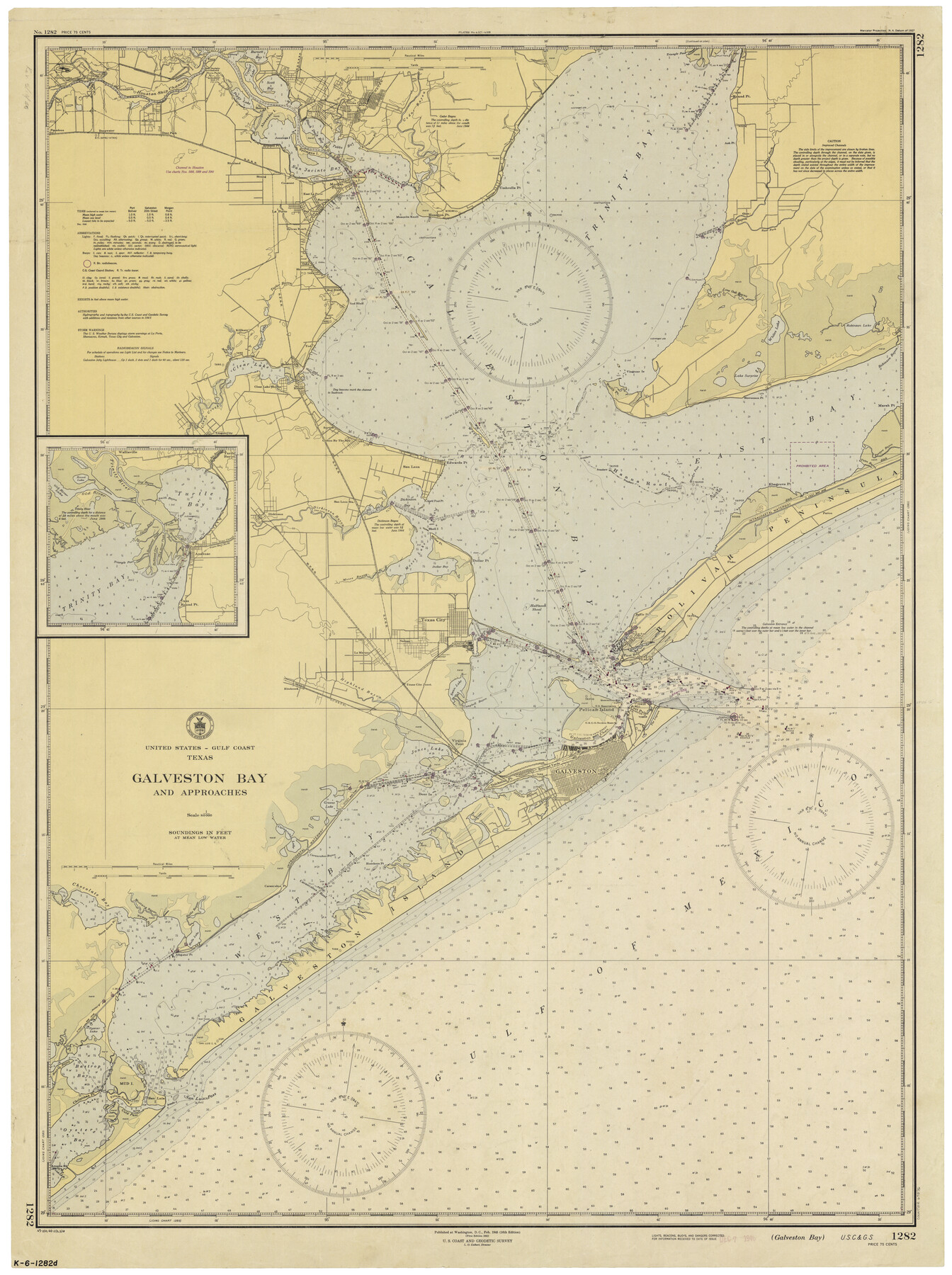
Galveston Bay and Approaches
K-6-1282d
-
Map/Doc
69876
-
Collection
General Map Collection
-
Object Dates
1946/5/18 (Creation Date)
-
Counties
Galveston Brazoria Chambers Harris
-
Subjects
Nautical Charts
-
Height x Width
45.5 x 34.0 inches
115.6 x 86.4 cm
Part of: General Map Collection
Medina County Working Sketch 22

Print $20.00
- Digital $50.00
Medina County Working Sketch 22
1984
Size 44.5 x 32.3 inches
Map/Doc 70937
Right of Way & Track Map, St. Louis, Brownsville & Mexico Ry. operated by St. Louis, Brownsville & Mexico Ry. Co.

Print $40.00
- Digital $50.00
Right of Way & Track Map, St. Louis, Brownsville & Mexico Ry. operated by St. Louis, Brownsville & Mexico Ry. Co.
1919
Size 25.5 x 57.1 inches
Map/Doc 64624
Chambers County Rolled Sketch 32

Print $20.00
- Digital $50.00
Chambers County Rolled Sketch 32
1951
Size 26.7 x 37.8 inches
Map/Doc 5432
A Topographical Map of The Government Tract Adjoining the City of Austin

Print $20.00
- Digital $50.00
A Topographical Map of The Government Tract Adjoining the City of Austin
1840
Size 44.5 x 36.0 inches
Map/Doc 82031
Aransas County Sketch File 28

Print $16.00
- Digital $50.00
Aransas County Sketch File 28
1973
Size 11.3 x 8.8 inches
Map/Doc 13226
Haskell County Rolled Sketch 13

Print $3.00
- Digital $50.00
Haskell County Rolled Sketch 13
1991
Size 11.0 x 17.1 inches
Map/Doc 6171
Young County Sketch File 10

Print $20.00
- Digital $50.00
Young County Sketch File 10
Size 14.1 x 17.7 inches
Map/Doc 12711
Erath County Sketch File 11

Print $4.00
- Digital $50.00
Erath County Sketch File 11
1871
Size 12.8 x 8.1 inches
Map/Doc 22279

Sherman County Sketch File 3

Print $26.00
- Digital $50.00
Sherman County Sketch File 3
1925
Size 7.7 x 8.9 inches
Map/Doc 36675
Brazoria County NRC Article 33.136 Sketch 7

Print $21.00
- Digital $50.00
Brazoria County NRC Article 33.136 Sketch 7
2004
Size 23.7 x 33.3 inches
Map/Doc 82907
Pecos County Rolled Sketch 146A

Print $37.00
- Digital $50.00
Pecos County Rolled Sketch 146A
1957
Size 10.4 x 15.2 inches
Map/Doc 48396
You may also like
Duval County Rolled Sketch 36

Print $20.00
- Digital $50.00
Duval County Rolled Sketch 36
1952
Size 27.7 x 21.9 inches
Map/Doc 5751
[Sketch of Surveys south of League 153]
![90437, [Sketch of Surveys south of League 153], Twichell Survey Records](https://historictexasmaps.com/wmedia_w700/maps/90437-1.tif.jpg)
Print $2.00
- Digital $50.00
[Sketch of Surveys south of League 153]
Size 9.5 x 5.9 inches
Map/Doc 90437
Pecos County Working Sketch 15

Print $20.00
- Digital $50.00
Pecos County Working Sketch 15
1914
Size 29.8 x 15.4 inches
Map/Doc 71485
Rusk County Working Sketch 15

Print $20.00
- Digital $50.00
Rusk County Working Sketch 15
1972
Size 29.6 x 43.8 inches
Map/Doc 63650
McMullen County Working Sketch 44

Print $20.00
- Digital $50.00
McMullen County Working Sketch 44
1981
Size 35.1 x 41.2 inches
Map/Doc 70745
Kerr County Working Sketch 22

Print $40.00
- Digital $50.00
Kerr County Working Sketch 22
1965
Size 50.9 x 40.4 inches
Map/Doc 70053
Flight Mission No. BRE-1P, Frame 30, Nueces County

Print $20.00
- Digital $50.00
Flight Mission No. BRE-1P, Frame 30, Nueces County
1956
Size 18.4 x 22.3 inches
Map/Doc 86626
Travis County Working Sketch 43

Print $20.00
- Digital $50.00
Travis County Working Sketch 43
1974
Size 24.1 x 24.6 inches
Map/Doc 69427
Liberty County Rolled Sketch 13

Print $20.00
- Digital $50.00
Liberty County Rolled Sketch 13
1983
Size 27.0 x 37.8 inches
Map/Doc 6619
Webb County Sketch File 3

Print $8.00
- Digital $50.00
Webb County Sketch File 3
Size 9.8 x 9.3 inches
Map/Doc 39713
Record of Spanish Titles, Vol. II

Record of Spanish Titles, Vol. II
Size 19.2 x 12.8 inches
Map/Doc 94527
Navarro County Sketch File 8

Print $4.00
- Digital $50.00
Navarro County Sketch File 8
1849
Size 13.2 x 8.5 inches
Map/Doc 32315