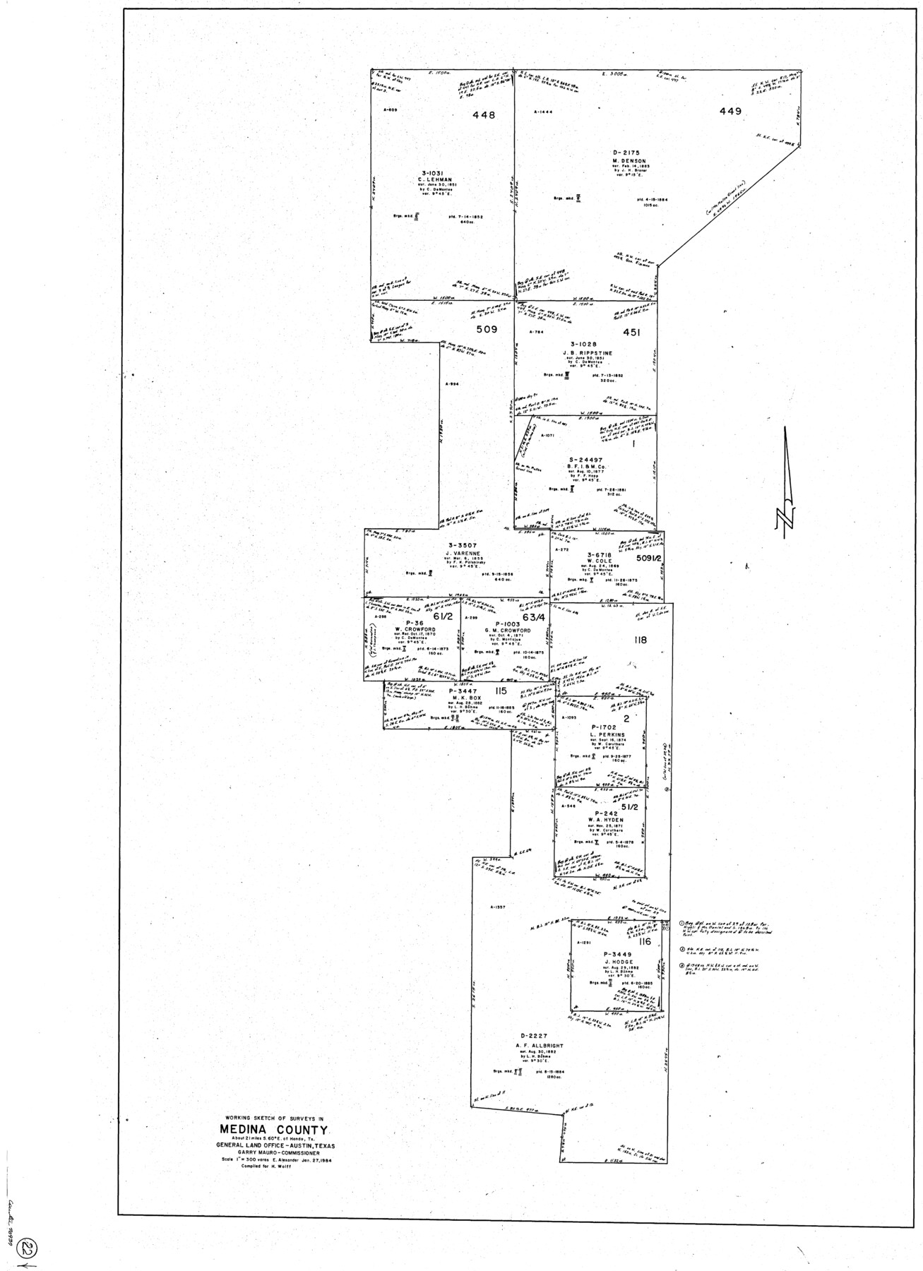
Medina County Working Sketch 22
-
Map/Doc
70937
-
Collection
General Map Collection
-
Object Dates
1/27/1984 (Creation Date)
-
People and Organizations
Earl Alexander (Draftsman)
-
Counties
Medina
-
Subjects
Surveying Working Sketch
-
Height x Width
44.5 x 32.3 inches
113.0 x 82.0 cm
-
Scale
1" = 300 varas
Part of: General Map Collection
Real County Sketch File 16

Print $20.00
- Digital $50.00
Real County Sketch File 16
1934
Size 23.1 x 22.1 inches
Map/Doc 12234
Schleicher County Working Sketch 13

Print $20.00
- Digital $50.00
Schleicher County Working Sketch 13
1926
Size 19.6 x 16.2 inches
Map/Doc 63815
Erath County Working Sketch 8

Print $20.00
- Digital $50.00
Erath County Working Sketch 8
1936
Size 16.0 x 16.2 inches
Map/Doc 69089
Maps & Lists Showing Prison Lands (Oil & Gas) Leased as of June 1955

Digital $50.00
Maps & Lists Showing Prison Lands (Oil & Gas) Leased as of June 1955
Size 11.1 x 9.0 inches
Map/Doc 62872
Flight Mission No. DCL-6C, Frame 72, Kenedy County

Print $20.00
- Digital $50.00
Flight Mission No. DCL-6C, Frame 72, Kenedy County
1943
Size 18.6 x 22.3 inches
Map/Doc 85914
Nueces County Aerial Photograph Index Sheet 23

Print $20.00
- Digital $50.00
Nueces County Aerial Photograph Index Sheet 23
1938
Size 24.4 x 20.3 inches
Map/Doc 86844
Crockett County Rolled Sketch 29

Print $20.00
- Digital $50.00
Crockett County Rolled Sketch 29
1927
Size 21.9 x 36.6 inches
Map/Doc 5588
Brazoria County Sketch File 26

Print $40.00
- Digital $50.00
Brazoria County Sketch File 26
Size 13.6 x 13.6 inches
Map/Doc 15028
Deaf Smith County Sketch File Z

Print $34.00
- Digital $50.00
Deaf Smith County Sketch File Z
1903
Size 9.6 x 4.7 inches
Map/Doc 20651
Flight Mission No. DQO-2K, Frame 92, Galveston County

Print $20.00
- Digital $50.00
Flight Mission No. DQO-2K, Frame 92, Galveston County
1952
Size 18.8 x 22.5 inches
Map/Doc 85019
Atascosa County Sketch File 13

Print $4.00
- Digital $50.00
Atascosa County Sketch File 13
1867
Size 12.8 x 8.2 inches
Map/Doc 13771
Garza County Rolled Sketch 13

Print $26.00
- Digital $50.00
Garza County Rolled Sketch 13
1935
Size 45.5 x 36.7 inches
Map/Doc 9047
You may also like
Wise County Sketch File 2a

Print $4.00
- Digital $50.00
Wise County Sketch File 2a
1856
Size 12.3 x 8.1 inches
Map/Doc 40526

Montague County Working Sketch 14

Print $20.00
- Digital $50.00
Montague County Working Sketch 14
1940
Size 28.4 x 17.9 inches
Map/Doc 71080
Crockett County Rolled Sketch 27A

Print $40.00
- Digital $50.00
Crockett County Rolled Sketch 27A
1925
Size 22.3 x 59.5 inches
Map/Doc 8692
Throckmorton County Sketch File 9

Print $7.00
- Digital $50.00
Throckmorton County Sketch File 9
1910
Size 8.4 x 8.4 inches
Map/Doc 38099
Matagorda County Working Sketch Graphic Index, Sheet 1 (Sketches 1 to 16)

Print $40.00
- Digital $50.00
Matagorda County Working Sketch Graphic Index, Sheet 1 (Sketches 1 to 16)
1920
Size 40.0 x 48.8 inches
Map/Doc 76633
Webb County Working Sketch 16

Print $20.00
- Digital $50.00
Webb County Working Sketch 16
1923
Size 27.6 x 32.1 inches
Map/Doc 72381
Polk County Working Sketch 12

Print $20.00
- Digital $50.00
Polk County Working Sketch 12
1942
Size 26.6 x 17.3 inches
Map/Doc 71627
[Canadian River North]
![91826, [Canadian River North], Twichell Survey Records](https://historictexasmaps.com/wmedia_w700/maps/91826-1.tif.jpg)
Print $3.00
- Digital $50.00
[Canadian River North]
Size 17.9 x 11.7 inches
Map/Doc 91826
Swisher County Sketch File 2

Print $8.00
- Digital $50.00
Swisher County Sketch File 2
1891
Size 14.3 x 8.6 inches
Map/Doc 37574

Brazoria County NRC Article 33.136 Location Key Sheet

Print $20.00
- Digital $50.00
Brazoria County NRC Article 33.136 Location Key Sheet
1965
Size 27.0 x 22.0 inches
Map/Doc 77007