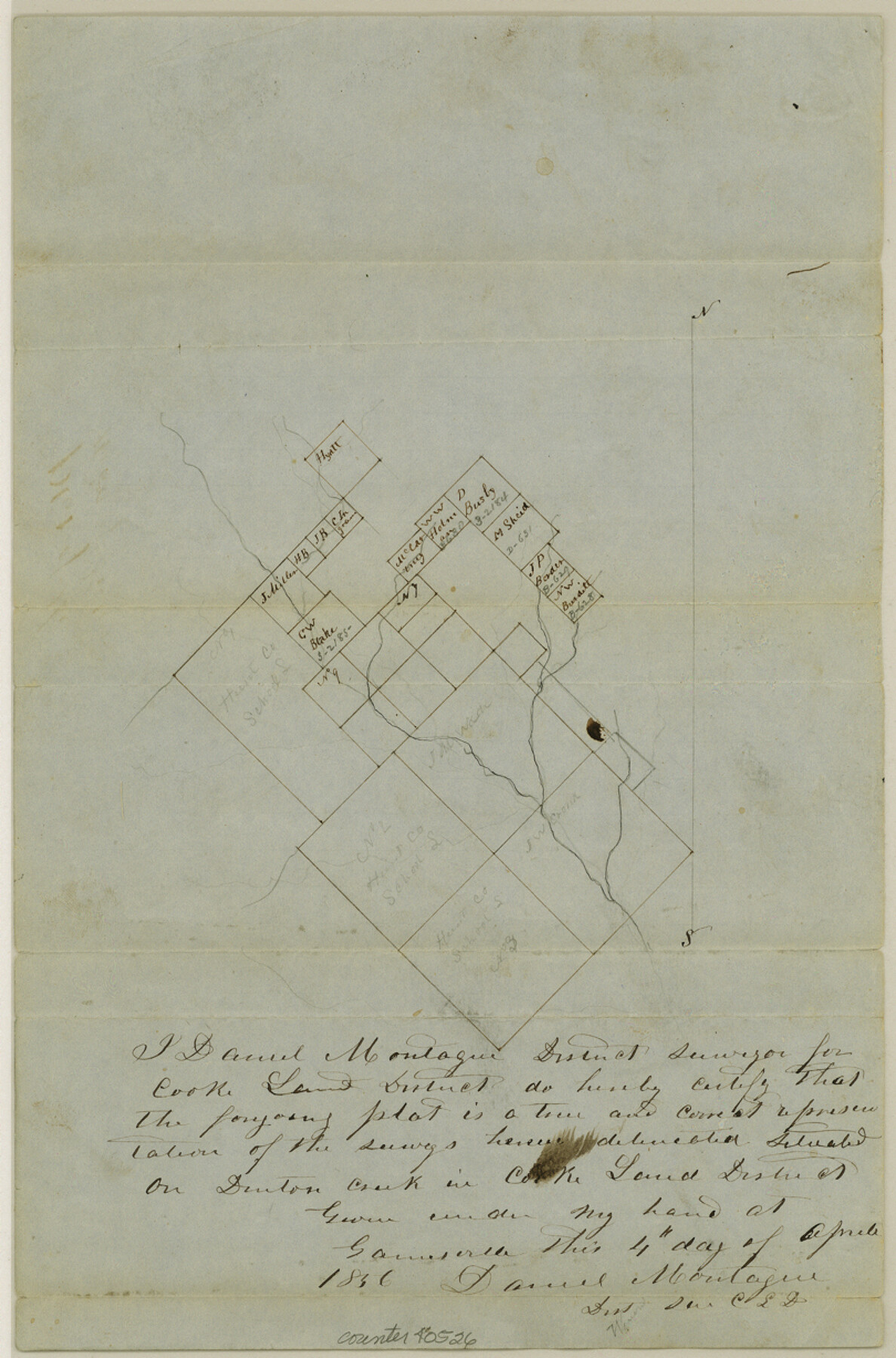
Wise County Sketch File 2a
[Sketch of surveys near Denton Creek in the north part of the county]
-
Map/Doc
40526
-
Collection
General Map Collection
-
Object Dates
4/4/1856 (Creation Date)
4/24/1856 (File Date)
-
People and Organizations
Daniel Montague (Surveyor/Engineer)
-
Counties
Wise Montague
-
Subjects
Surveying Sketch File
-
Height x Width
12.3 x 8.1 inches
31.2 x 20.6 cm
-
Medium
paper, manuscript
-
Features
Denton Creek
Part of: General Map Collection

Milam County Working Sketch 4

Print $20.00
- Digital $50.00
Milam County Working Sketch 4
1954
Size 26.1 x 32.4 inches
Map/Doc 71019
Map of the country adjacent to the left bank of the Rio Grande below Matamoros

Print $20.00
- Digital $50.00
Map of the country adjacent to the left bank of the Rio Grande below Matamoros
1847
Size 18.3 x 27.5 inches
Map/Doc 72870
Map of section no. 11 of a survey of Padre Island made for the Office of the Attorney General of the State of Texas

Print $40.00
- Digital $50.00
Map of section no. 11 of a survey of Padre Island made for the Office of the Attorney General of the State of Texas
1941
Size 60.1 x 40.4 inches
Map/Doc 2267
Brewster County Rolled Sketch 67

Print $20.00
- Digital $50.00
Brewster County Rolled Sketch 67
1940
Size 32.0 x 23.5 inches
Map/Doc 5233
Cameron County Rolled Sketch Z1

Print $20.00
- Digital $50.00
Cameron County Rolled Sketch Z1
1937
Size 23.4 x 41.4 inches
Map/Doc 5401
Childress County Rolled Sketch 5A

Print $20.00
- Digital $50.00
Childress County Rolled Sketch 5A
Size 32.9 x 21.9 inches
Map/Doc 5440
Fractional Township No. 8 South Range No. 6 West of the Indian Meridian, Indian Territory

Print $20.00
- Digital $50.00
Fractional Township No. 8 South Range No. 6 West of the Indian Meridian, Indian Territory
1898
Size 19.3 x 24.4 inches
Map/Doc 75187
Reeves County Rolled Sketch 17

Print $20.00
- Digital $50.00
Reeves County Rolled Sketch 17
1963
Size 28.4 x 36.1 inches
Map/Doc 7486
Donley County Sketch File B2

Print $20.00
- Digital $50.00
Donley County Sketch File B2
1918
Size 15.1 x 22.4 inches
Map/Doc 11372
Atascosa County Working Sketch 19

Print $20.00
- Digital $50.00
Atascosa County Working Sketch 19
1952
Size 24.4 x 27.3 inches
Map/Doc 67215
Lampasas County Sketch File 4

Print $4.00
- Digital $50.00
Lampasas County Sketch File 4
1861
Size 12.3 x 8.2 inches
Map/Doc 29394
You may also like
Layout of the porciones as described in the Visita General of Mier, 1767

Layout of the porciones as described in the Visita General of Mier, 1767
2009
Size 11.0 x 8.5 inches
Map/Doc 94043
[Blocks T1, T2, T3, and Vicinity]
![90982, [Blocks T1, T2, T3, and Vicinity], Twichell Survey Records](https://historictexasmaps.com/wmedia_w700/maps/90982-1.tif.jpg)
Print $20.00
- Digital $50.00
[Blocks T1, T2, T3, and Vicinity]
Size 30.6 x 32.7 inches
Map/Doc 90982
Map of Terry County

Print $20.00
- Digital $50.00
Map of Terry County
Size 34.0 x 34.2 inches
Map/Doc 92933
Aransas County NRC Article 33.136 Sketch 5

Print $20.00
- Digital $50.00
Aransas County NRC Article 33.136 Sketch 5
2005
Size 18.5 x 24.7 inches
Map/Doc 83521
Angelina County Working Sketch 22a

Print $20.00
- Digital $50.00
Angelina County Working Sketch 22a
1953
Size 22.3 x 20.1 inches
Map/Doc 67103
Maps of Gulf Intracoastal Waterway, Texas - Sabine River to the Rio Grande and connecting waterways including ship channels

Print $20.00
- Digital $50.00
Maps of Gulf Intracoastal Waterway, Texas - Sabine River to the Rio Grande and connecting waterways including ship channels
1966
Size 14.6 x 21.7 inches
Map/Doc 61981
Baylor County Boundary File 16

Print $2.00
- Digital $50.00
Baylor County Boundary File 16
Size 11.2 x 8.7 inches
Map/Doc 50433
Houston County Sketch File 35

Print $8.00
- Digital $50.00
Houston County Sketch File 35
1840
Size 11.2 x 9.0 inches
Map/Doc 26813
Flight Mission No. CUI-1H, Frame 97, Milam County

Print $20.00
- Digital $50.00
Flight Mission No. CUI-1H, Frame 97, Milam County
1951
Size 18.5 x 22.2 inches
Map/Doc 86605
Parker County Sketch File 8

Print $6.00
- Digital $50.00
Parker County Sketch File 8
1859
Size 11.0 x 11.5 inches
Map/Doc 33536
Working Sketch in Deaf Smith County [east of Block K3]
![90605, Working Sketch in Deaf Smith County [east of Block K3], Twichell Survey Records](https://historictexasmaps.com/wmedia_w700/maps/90605-1.tif.jpg)
Print $20.00
- Digital $50.00
Working Sketch in Deaf Smith County [east of Block K3]
1919
Size 15.2 x 27.9 inches
Map/Doc 90605
Rusk County Working Sketch 16

Print $20.00
- Digital $50.00
Rusk County Working Sketch 16
1956
Size 32.1 x 42.7 inches
Map/Doc 63651