Houston County Sketch File 35
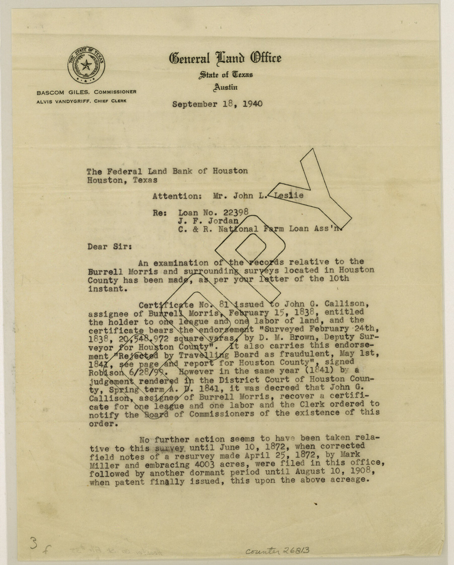
[Letter of explanation regarding the Burrell Morris and surrounding surveys]
-
Map/Doc
26813
-
Collection
General Map Collection
-
Object Dates
9/18/1840 (Creation Date)
3/15/1844 (File Date)
9/18/1940 (Correspondence Date)
2/24/1838 (Survey Date)
4/25/1872 (Survey Date)
7/4/1840 (Survey Date)
-
People and Organizations
Mark Miller (Surveyor/Engineer)
Bascom Giles (GLO Commissioner)
-
Counties
Houston
-
Subjects
Surveying Sketch File
-
Height x Width
11.2 x 9.0 inches
28.5 x 22.9 cm
-
Medium
paper, print
Part of: General Map Collection
Flight Mission No. CRC-3R, Frame 201, Chambers County

Print $20.00
- Digital $50.00
Flight Mission No. CRC-3R, Frame 201, Chambers County
1956
Size 18.6 x 22.4 inches
Map/Doc 84856
[Sabine Pass]
![78263, [Sabine Pass], General Map Collection](https://historictexasmaps.com/wmedia_w700/maps/78263.tif.jpg)
Print $20.00
- Digital $50.00
[Sabine Pass]
1916
Size 29.2 x 42.1 inches
Map/Doc 78263
Brewster County Rolled Sketch 122

Print $20.00
- Digital $50.00
Brewster County Rolled Sketch 122
1974
Size 33.4 x 24.8 inches
Map/Doc 5296
Hudspeth County Working Sketch 42

Print $20.00
- Digital $50.00
Hudspeth County Working Sketch 42
1981
Size 34.2 x 36.5 inches
Map/Doc 66327
Garza County Rolled Sketch 5B

Print $20.00
- Digital $50.00
Garza County Rolled Sketch 5B
Size 36.3 x 47.7 inches
Map/Doc 76031
Kinney County Working Sketch 33

Print $20.00
- Digital $50.00
Kinney County Working Sketch 33
1962
Size 39.0 x 44.2 inches
Map/Doc 70215
Gulf of Mexico

Print $20.00
- Digital $50.00
Gulf of Mexico
1946
Size 36.2 x 43.7 inches
Map/Doc 73550
Anderson County Boundary File 7

Print $10.00
- Digital $50.00
Anderson County Boundary File 7
Size 14.4 x 8.9 inches
Map/Doc 49751
Bell County Sketch File 21

Print $4.00
- Digital $50.00
Bell County Sketch File 21
1871
Size 8.0 x 9.7 inches
Map/Doc 14410
Anderson County Working Sketch 15

Print $20.00
- Digital $50.00
Anderson County Working Sketch 15
1937
Size 19.7 x 22.7 inches
Map/Doc 67015
San Patricio County Working Sketch 17

Print $20.00
- Digital $50.00
San Patricio County Working Sketch 17
1953
Size 32.9 x 26.8 inches
Map/Doc 63779
Bandera County Working Sketch 30

Print $20.00
- Digital $50.00
Bandera County Working Sketch 30
1969
Size 29.9 x 37.4 inches
Map/Doc 67626
You may also like

Kendall County Sketch File 1a

Print $18.00
- Digital $50.00
Kendall County Sketch File 1a
1873
Size 5.3 x 6.7 inches
Map/Doc 28673
McLennan County School Land Leagues 3 & 4

Print $20.00
- Digital $50.00
McLennan County School Land Leagues 3 & 4
Size 10.7 x 18.2 inches
Map/Doc 90930
Hunt County Working Sketch Graphic Index

Print $40.00
- Digital $50.00
Hunt County Working Sketch Graphic Index
1944
Size 50.5 x 37.0 inches
Map/Doc 76585
Travis County Working Sketch 31

Print $20.00
- Digital $50.00
Travis County Working Sketch 31
1965
Size 31.2 x 35.6 inches
Map/Doc 69415
Map of Hemphill County

Print $20.00
- Digital $50.00
Map of Hemphill County
1899
Size 41.2 x 38.5 inches
Map/Doc 95527
Eastland County Working Sketch 47

Print $20.00
- Digital $50.00
Eastland County Working Sketch 47
1981
Size 30.0 x 27.1 inches
Map/Doc 68828
Brewster County Rolled Sketch 60

Print $40.00
- Digital $50.00
Brewster County Rolled Sketch 60
Size 53.9 x 28.0 inches
Map/Doc 61784
Angelina County Sketch File 15f

Print $4.00
- Digital $50.00
Angelina County Sketch File 15f
Size 10.4 x 7.6 inches
Map/Doc 12994
Jim Hogg County Sketch File 8

Print $20.00
- Digital $50.00
Jim Hogg County Sketch File 8
1941
Size 21.9 x 27.0 inches
Map/Doc 11887
Map of Texas and part of New Mexico

Print $20.00
Map of Texas and part of New Mexico
1857
Size 17.4 x 23.1 inches
Map/Doc 95284
Bee County Working Sketch 14

Print $20.00
- Digital $50.00
Bee County Working Sketch 14
1948
Size 22.2 x 17.7 inches
Map/Doc 67264