Brewster County Rolled Sketch 60
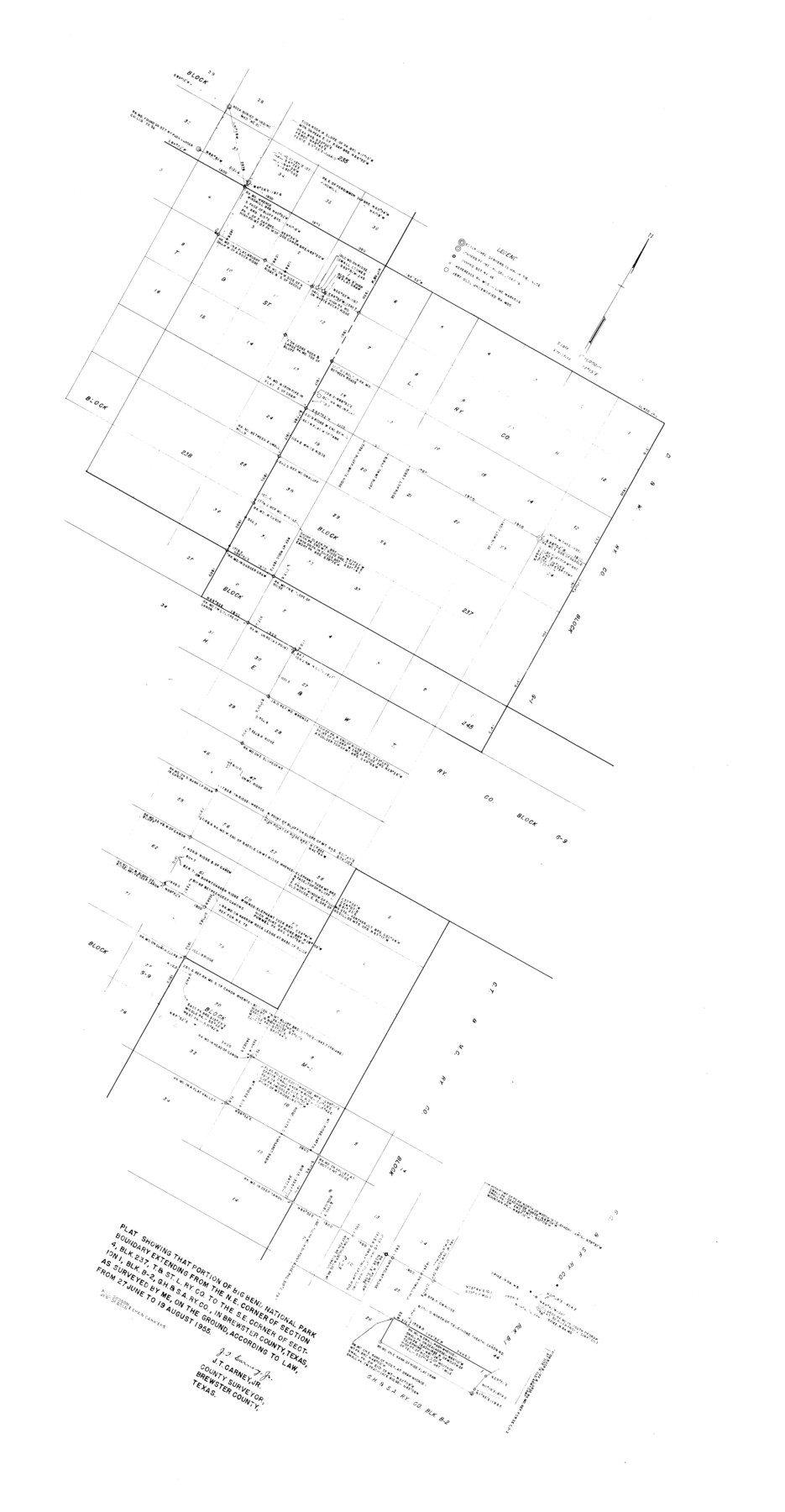
Plat showing that portion of Big Bend National Park boundary extending from the N.E. corner of section 4, Blk. 237, T. & St. L. Ry. Co. to the S.E. corner of section1, Blk. B-2, G. H. & S. A. Ry. Co.
-
Map/Doc
61784
-
Collection
General Map Collection
-
People and Organizations
J.T. Carney, Jr. (Surveyor/Engineer)
-
Counties
Brewster
-
Subjects
Surveying Rolled Sketch
-
Height x Width
53.9 x 28.0 inches
136.9 x 71.1 cm
Related maps
Brewster County Rolled Sketch 60

Print $40.00
- Digital $50.00
Brewster County Rolled Sketch 60
Size 36.6 x 50.3 inches
Map/Doc 10692
Brewster County Rolled Sketch 60

Print $40.00
- Digital $50.00
Brewster County Rolled Sketch 60
1942
Size 42.9 x 48.0 inches
Map/Doc 16960
Brewster County Rolled Sketch 60

Print $20.00
- Digital $50.00
Brewster County Rolled Sketch 60
Size 24.8 x 36.5 inches
Map/Doc 61783
Brewster County Rolled Sketch 60

Print $20.00
- Digital $50.00
Brewster County Rolled Sketch 60
Size 25.0 x 37.5 inches
Map/Doc 8484
Brewster County Rolled Sketch 60

Print $40.00
- Digital $50.00
Brewster County Rolled Sketch 60
Size 37.1 x 68.9 inches
Map/Doc 8485
Brewster County Rolled Sketch 60

Print $40.00
- Digital $50.00
Brewster County Rolled Sketch 60
Size 36.7 x 50.8 inches
Map/Doc 9200
Part of: General Map Collection
Amistad International Reservoir on Rio Grande 75

Print $20.00
- Digital $50.00
Amistad International Reservoir on Rio Grande 75
1949
Size 28.5 x 40.1 inches
Map/Doc 75503
Cass County Working Sketch 39

Print $20.00
- Digital $50.00
Cass County Working Sketch 39
1983
Size 26.3 x 34.6 inches
Map/Doc 67942
Right of Way and Track Map, the Missouri, Kansas and Texas Ry. of Texas - Henrietta Division

Print $20.00
- Digital $50.00
Right of Way and Track Map, the Missouri, Kansas and Texas Ry. of Texas - Henrietta Division
1918
Size 11.7 x 26.8 inches
Map/Doc 64767
Terry County Rolled Sketch 7

Print $20.00
- Digital $50.00
Terry County Rolled Sketch 7
1903
Size 19.6 x 19.9 inches
Map/Doc 7981
Flight Mission No. CRC-2R, Frame 192, Chambers County

Print $20.00
- Digital $50.00
Flight Mission No. CRC-2R, Frame 192, Chambers County
1956
Size 18.6 x 22.3 inches
Map/Doc 84770
Galveston County Rolled Sketch 10

Print $20.00
- Digital $50.00
Galveston County Rolled Sketch 10
1916
Size 21.0 x 38.0 inches
Map/Doc 5952
Parker County Sketch File 22

Print $4.00
- Digital $50.00
Parker County Sketch File 22
Size 8.7 x 6.3 inches
Map/Doc 33562
Colorado County Sketch File 18

Print $40.00
- Digital $50.00
Colorado County Sketch File 18
1897
Size 12.5 x 15.8 inches
Map/Doc 18950
Val Verde County Sketch File 44

Print $22.00
- Digital $50.00
Val Verde County Sketch File 44
1940
Size 9.0 x 14.2 inches
Map/Doc 39309
Kent County Rolled Sketch 7

Print $40.00
- Digital $50.00
Kent County Rolled Sketch 7
1954
Size 51.8 x 42.6 inches
Map/Doc 10221
Galveston County Rolled Sketch 30

Print $20.00
- Digital $50.00
Galveston County Rolled Sketch 30
1979
Size 28.0 x 39.8 inches
Map/Doc 5964
Angelina County Sketch File 26

Print $40.00
- Digital $50.00
Angelina County Sketch File 26
1909
Size 18.0 x 23.0 inches
Map/Doc 10817
You may also like
San Saba County Working Sketch 1

Print $20.00
- Digital $50.00
San Saba County Working Sketch 1
1919
Size 15.3 x 15.3 inches
Map/Doc 63789
Gillespie County Rolled Sketch 2

Print $20.00
- Digital $50.00
Gillespie County Rolled Sketch 2
1977
Size 22.8 x 22.7 inches
Map/Doc 6009
Travis County Working Sketch 56

Print $20.00
- Digital $50.00
Travis County Working Sketch 56
1989
Size 19.7 x 20.4 inches
Map/Doc 69440
Copy of a chart of Aransas and Corpus Christi Bays by an inhabitant of St. Joseph's Island, the main features of which have been verified by the examinations of Capt. Crosman and other officers of the army

Print $20.00
- Digital $50.00
Copy of a chart of Aransas and Corpus Christi Bays by an inhabitant of St. Joseph's Island, the main features of which have been verified by the examinations of Capt. Crosman and other officers of the army
1845
Size 26.4 x 18.5 inches
Map/Doc 73013
[Surveys in the Milam District on Coryell Creek and the Bosque River]
![3171, [Surveys in the Milam District on Coryell Creek and the Bosque River], General Map Collection](https://historictexasmaps.com/wmedia_w700/maps/3171.tif.jpg)
Print $20.00
- Digital $50.00
[Surveys in the Milam District on Coryell Creek and the Bosque River]
1846
Size 14.0 x 15.8 inches
Map/Doc 3171
Blanco County Sketch File 27

Print $6.00
- Digital $50.00
Blanco County Sketch File 27
1888
Size 14.1 x 11.2 inches
Map/Doc 14621
Bandera County Working Sketch 52

Print $20.00
- Digital $50.00
Bandera County Working Sketch 52
Size 37.2 x 37.6 inches
Map/Doc 67648
Duval County Boundary File 4

Print $40.00
- Digital $50.00
Duval County Boundary File 4
Size 39.5 x 13.7 inches
Map/Doc 52767
The Wonderful Lower Rio Grande Valley

Print $20.00
- Digital $50.00
The Wonderful Lower Rio Grande Valley
1909
Size 21.6 x 22.9 inches
Map/Doc 95798

Chambers County NRC Article 33.136 Sketch 6

Print $58.00
- Digital $50.00
Chambers County NRC Article 33.136 Sketch 6
2007
Size 11.0 x 8.5 inches
Map/Doc 88802
Duval County Sketch File 36b

Print $60.00
- Digital $50.00
Duval County Sketch File 36b
1935
Size 28.4 x 23.3 inches
Map/Doc 11393