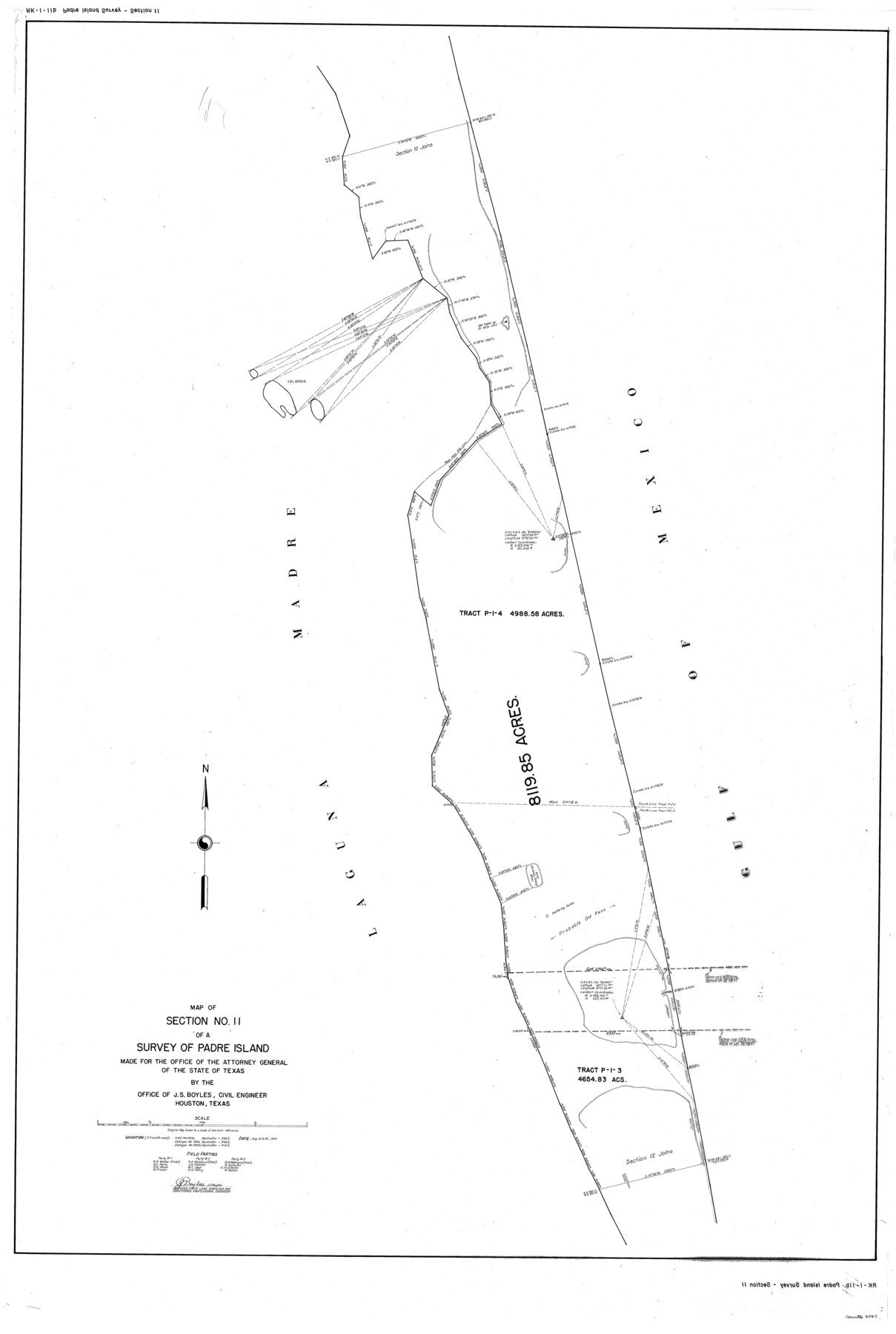
Map of section no. 11 of a survey of Padre Island made for the Office of the Attorney General of the State of Texas
-
Map/Doc
2267
-
Collection
General Map Collection
-
Object Dates
1941/8/18 (Creation Date)
-
People and Organizations
J.S. Boyles (Surveyor/Engineer)
-
Counties
Cameron
-
Height x Width
60.1 x 40.4 inches
152.7 x 102.6 cm
-
Medium
mylar, print
-
Comments
Map 11 of 12. See map numbers 2257 through 2268 (inclusive) for complete set of maps. See 2271 for transcription of field notes.
Related maps
Map of survey of a part of Padre and Mustang Islands made for the Office of the Attorney General of the State of Texas

Print $20.00
- Digital $50.00
Map of survey of a part of Padre and Mustang Islands made for the Office of the Attorney General of the State of Texas
1941
Size 40.8 x 39.5 inches
Map/Doc 2257
Map of sections 1 & 2 of a survey of Padre Island made for the Office of the Attorney General of the State of Texas

Print $20.00
- Digital $50.00
Map of sections 1 & 2 of a survey of Padre Island made for the Office of the Attorney General of the State of Texas
1941
Size 40.8 x 39.8 inches
Map/Doc 2258
Map of section no. 3 of a survey of Padre Island made for the Office of the Attorney General of the State of Texas

Print $40.00
- Digital $50.00
Map of section no. 3 of a survey of Padre Island made for the Office of the Attorney General of the State of Texas
1941
Size 49.6 x 40.2 inches
Map/Doc 2259
Map of section no. 4 of a survey of Padre Island made for the Office of the Attorney General of the State of Texas

Print $40.00
- Digital $50.00
Map of section no. 4 of a survey of Padre Island made for the Office of the Attorney General of the State of Texas
1941
Size 82.6 x 40.8 inches
Map/Doc 2260
Map of section no. 5 of a survey of Padre Island made for the Office of the Attorney General of the State of Texas

Print $40.00
- Digital $50.00
Map of section no. 5 of a survey of Padre Island made for the Office of the Attorney General of the State of Texas
1941
Size 49.8 x 40.0 inches
Map/Doc 2261
Map of section no. 6 of a survey of Padre Island made for the Office of the Attorney General of the State of Texas

Print $40.00
- Digital $50.00
Map of section no. 6 of a survey of Padre Island made for the Office of the Attorney General of the State of Texas
1941
Size 57.9 x 40.8 inches
Map/Doc 2262
Map of section no. 7 of a survey of Padre Island made for the Office of the Attorney General of the State of Texas

Print $40.00
- Digital $50.00
Map of section no. 7 of a survey of Padre Island made for the Office of the Attorney General of the State of Texas
1941
Size 56.3 x 41.2 inches
Map/Doc 2263
Map of section no. 8 of a survey of Padre Island made for the Office of the Attorney General of the State of Texas

Print $40.00
- Digital $50.00
Map of section no. 8 of a survey of Padre Island made for the Office of the Attorney General of the State of Texas
1941
Size 56.2 x 40.3 inches
Map/Doc 2264
Map of section no. 9 of a survey of Padre Island made for the Office of the Attorney General of the State of Texas

Print $40.00
- Digital $50.00
Map of section no. 9 of a survey of Padre Island made for the Office of the Attorney General of the State of Texas
1941
Size 58.3 x 42.5 inches
Map/Doc 2265
Map of section no. 10 of a survey of Padre Island made for the Office of the Attorney General of the State of Texas

Print $40.00
- Digital $50.00
Map of section no. 10 of a survey of Padre Island made for the Office of the Attorney General of the State of Texas
1941
Size 57.2 x 40.6 inches
Map/Doc 2266
Map of section no. 12 of a survey of Padre Island made for the Office of the Attorney General of the State of Texas

Print $40.00
- Digital $50.00
Map of section no. 12 of a survey of Padre Island made for the Office of the Attorney General of the State of Texas
1941
Size 75.9 x 41.0 inches
Map/Doc 2268
Field Notes of a Survey of Padre Island

Print $20.00
- Digital $50.00
Field Notes of a Survey of Padre Island
1941
Size 43.2 x 30.0 inches
Map/Doc 2271
Part of: General Map Collection
Hopkins County Sketch File 28

Print $20.00
- Digital $50.00
Hopkins County Sketch File 28
Size 24.8 x 34.0 inches
Map/Doc 11786
Floyd County Working Sketch 2

Print $20.00
- Digital $50.00
Floyd County Working Sketch 2
1911
Size 41.0 x 24.8 inches
Map/Doc 69181
Cass County Sketch File 17

Print $4.00
- Digital $50.00
Cass County Sketch File 17
Size 8.2 x 10.2 inches
Map/Doc 17418
Map of Hardin County

Print $20.00
- Digital $50.00
Map of Hardin County
1902
Size 43.1 x 44.2 inches
Map/Doc 66854
Starr County Sketch File 44

Print $8.00
- Digital $50.00
Starr County Sketch File 44
1944
Size 14.1 x 8.8 inches
Map/Doc 36995
Falls County Sketch File 12

Print $8.00
- Digital $50.00
Falls County Sketch File 12
1870
Size 8.2 x 10.1 inches
Map/Doc 22364
Maps of Gulf Intracoastal Waterway, Texas - Sabine River to the Rio Grande and connecting waterways including ship channels

Print $20.00
- Digital $50.00
Maps of Gulf Intracoastal Waterway, Texas - Sabine River to the Rio Grande and connecting waterways including ship channels
1966
Size 14.5 x 22.3 inches
Map/Doc 61936
Cass County Sketch File 2

Print $4.00
- Digital $50.00
Cass County Sketch File 2
1849
Size 12.4 x 7.7 inches
Map/Doc 17394
[Sketch for Mineral Application 27669 - Trinity River, Frank R. Graves]
![2856, [Sketch for Mineral Application 27669 - Trinity River, Frank R. Graves], General Map Collection](https://historictexasmaps.com/wmedia_w700/maps/2856-1.tif.jpg)
Print $20.00
- Digital $50.00
[Sketch for Mineral Application 27669 - Trinity River, Frank R. Graves]
1934
Size 24.9 x 36.0 inches
Map/Doc 2856

Webb County Sketch File 9-2

Print $4.00
- Digital $50.00
Webb County Sketch File 9-2
1916
Size 11.3 x 8.6 inches
Map/Doc 39764
Garza County Rolled Sketch 11 & 11A

Print $31.00
- Digital $50.00
Garza County Rolled Sketch 11 & 11A
1915
Size 10.3 x 15.5 inches
Map/Doc 45214
You may also like
San Jacinto County Rolled Sketch 3

Print $40.00
- Digital $50.00
San Jacinto County Rolled Sketch 3
Size 24.4 x 59.4 inches
Map/Doc 9880
Kimble County Sketch File B

Print $22.00
- Digital $50.00
Kimble County Sketch File B
Size 14.3 x 12.7 inches
Map/Doc 28963
Flight Mission No. BRE-2P, Frame 111, Nueces County

Print $20.00
- Digital $50.00
Flight Mission No. BRE-2P, Frame 111, Nueces County
1956
Size 18.4 x 22.6 inches
Map/Doc 86797
Flight Mission No. DQN-5K, Frame 76, Calhoun County

Print $20.00
- Digital $50.00
Flight Mission No. DQN-5K, Frame 76, Calhoun County
1953
Size 18.7 x 22.3 inches
Map/Doc 84409
Maps of Gulf Intracoastal Waterway, Texas - Sabine River to the Rio Grande and connecting waterways including ship channels

Print $20.00
- Digital $50.00
Maps of Gulf Intracoastal Waterway, Texas - Sabine River to the Rio Grande and connecting waterways including ship channels
1966
Size 14.5 x 22.4 inches
Map/Doc 61918
Sutton County Sketch File 51

Print $6.00
- Digital $50.00
Sutton County Sketch File 51
1947
Size 11.3 x 8.9 inches
Map/Doc 37526
[Map of Hardin County]
![3630, [Map of Hardin County], General Map Collection](https://historictexasmaps.com/wmedia_w700/maps/3630-2.tif.jpg)
Print $20.00
- Digital $50.00
[Map of Hardin County]
1862
Size 18.0 x 22.0 inches
Map/Doc 3630
Traveller's Map of the State of Texas

Print $20.00
- Digital $50.00
Traveller's Map of the State of Texas
1867
Size 40.7 x 38.7 inches
Map/Doc 2130

Pecos County Rolled Sketch 70

Print $40.00
- Digital $50.00
Pecos County Rolled Sketch 70
1929
Size 49.3 x 21.6 inches
Map/Doc 9708
Map of Leon County

Print $40.00
- Digital $50.00
Map of Leon County
Size 49.7 x 42.0 inches
Map/Doc 66900
Duval County Sketch File 19

Print $4.00
- Digital $50.00
Duval County Sketch File 19
1880
Size 10.3 x 8.2 inches
Map/Doc 21316