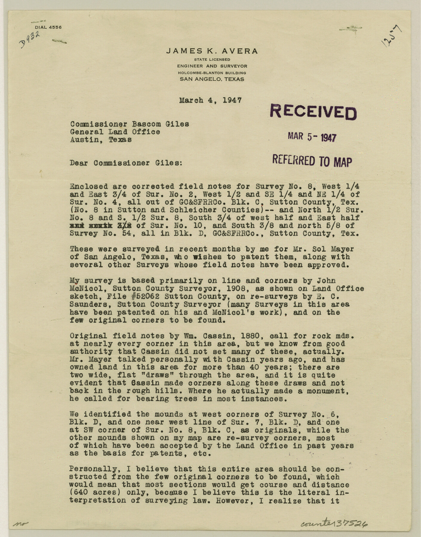
Sutton County Sketch File 51
[Report of survey of Sol Mayer Ranch]
-
Map/Doc
37526
-
Collection
General Map Collection
-
Object Dates
1947/3/4 (Creation Date)
1947/3/25 (File Date)
1880 (Survey Date)
-
People and Organizations
James K. Avera (Surveyor/Engineer)
John McNichol (Surveyor/Engineer)
Edgar C. Saunders (Surveyor/Engineer)
William Cassin (Surveyor/Engineer)
-
Counties
Sutton Schleicher
-
Subjects
Surveying Sketch File
-
Height x Width
11.3 x 8.9 inches
28.7 x 22.6 cm
-
Medium
paper, print
-
Features
Sol Mayer Ranch
Part of: General Map Collection
Aransas County Working Sketch 16

Print $40.00
- Digital $50.00
Aransas County Working Sketch 16
1965
Size 55.3 x 43.1 inches
Map/Doc 67183
Flight Mission No. CRC-3R, Frame 22, Chambers County

Print $20.00
- Digital $50.00
Flight Mission No. CRC-3R, Frame 22, Chambers County
1956
Size 18.6 x 22.3 inches
Map/Doc 84796
Wise County Sketch File 48

Print $10.00
- Digital $50.00
Wise County Sketch File 48
1922
Size 14.2 x 8.7 inches
Map/Doc 40613
Flight Mission No. DCL-6C, Frame 18, Kenedy County

Print $20.00
- Digital $50.00
Flight Mission No. DCL-6C, Frame 18, Kenedy County
1943
Size 18.6 x 22.5 inches
Map/Doc 85875
Presidio County Sketch File R

Print $18.00
- Digital $50.00
Presidio County Sketch File R
Size 10.3 x 8.4 inches
Map/Doc 34590
Current Miscellaneous File 82

Print $4.00
- Digital $50.00
Current Miscellaneous File 82
Size 12.0 x 8.8 inches
Map/Doc 74224
Hill County Sketch File 8a

Print $4.00
- Digital $50.00
Hill County Sketch File 8a
1858
Size 10.2 x 8.1 inches
Map/Doc 26474
Terry County Sketch File 13

Print $20.00
- Digital $50.00
Terry County Sketch File 13
Size 43.2 x 10.2 inches
Map/Doc 10397
Gonzales County

Print $20.00
- Digital $50.00
Gonzales County
1853
Size 23.4 x 22.4 inches
Map/Doc 3591
Harbor of Brazos Santiago, Texas

Print $20.00
- Digital $50.00
Harbor of Brazos Santiago, Texas
1887
Size 27.1 x 18.3 inches
Map/Doc 72997
Parker County Working Sketch 15

Print $20.00
- Digital $50.00
Parker County Working Sketch 15
1982
Map/Doc 71465
Coke County Sketch File AB

Print $12.00
- Digital $50.00
Coke County Sketch File AB
1884
Size 14.1 x 8.7 inches
Map/Doc 18608
You may also like
Brazos River, Brazos River Sheet 1

Print $20.00
- Digital $50.00
Brazos River, Brazos River Sheet 1
1926
Size 20.7 x 25.3 inches
Map/Doc 69665
Loving County Working Sketch 21

Print $20.00
- Digital $50.00
Loving County Working Sketch 21
1984
Size 26.7 x 36.0 inches
Map/Doc 70655
Galveston County Rolled Sketch Z63

Print $20.00
- Digital $50.00
Galveston County Rolled Sketch Z63
1935
Size 34.6 x 22.5 inches
Map/Doc 5995
General Highway Map Hockley County, Texas

Print $20.00
- Digital $50.00
General Highway Map Hockley County, Texas
1949
Size 25.7 x 18.8 inches
Map/Doc 92209
Map of east part of West Bay & SW part of Galveston Bay, Galveston County showing subdivision for mineral development

Print $40.00
- Digital $50.00
Map of east part of West Bay & SW part of Galveston Bay, Galveston County showing subdivision for mineral development
1963
Size 43.0 x 60.8 inches
Map/Doc 2976
[North Part of T. A. Thomson, Block T]
![91075, [North Part of T. A. Thomson, Block T], Twichell Survey Records](https://historictexasmaps.com/wmedia_w700/maps/91075-1.tif.jpg)
Print $20.00
- Digital $50.00
[North Part of T. A. Thomson, Block T]
Size 17.6 x 14.3 inches
Map/Doc 91075
Colorado County Rolled Sketch 4

Print $20.00
- Digital $50.00
Colorado County Rolled Sketch 4
1944
Size 31.9 x 21.9 inches
Map/Doc 8643
Flight Mission No. BRA-16M, Frame 165, Jefferson County

Print $20.00
- Digital $50.00
Flight Mission No. BRA-16M, Frame 165, Jefferson County
1953
Size 18.6 x 22.4 inches
Map/Doc 85763
Flight Mission No. CUG-1P, Frame 169, Kleberg County

Print $20.00
- Digital $50.00
Flight Mission No. CUG-1P, Frame 169, Kleberg County
1956
Size 18.6 x 22.4 inches
Map/Doc 86176
Flight Mission No. CLL-3N, Frame 13, Willacy County

Print $20.00
- Digital $50.00
Flight Mission No. CLL-3N, Frame 13, Willacy County
1954
Size 18.4 x 22.1 inches
Map/Doc 87079
San Benito, Texas in the Lower Rio Grande Valley [Frisco Lines]
![95795, San Benito, Texas in the Lower Rio Grande Valley [Frisco Lines], Cobb Digital Map Collection](https://historictexasmaps.com/wmedia_w700/maps/95795.tif.jpg)
Print $20.00
- Digital $50.00
San Benito, Texas in the Lower Rio Grande Valley [Frisco Lines]
1910
Size 19.5 x 19.4 inches
Map/Doc 95795
Martin County Working Sketch 1

Print $20.00
- Digital $50.00
Martin County Working Sketch 1
1922
Size 21.8 x 16.9 inches
Map/Doc 70819