Galveston County Rolled Sketch Z63
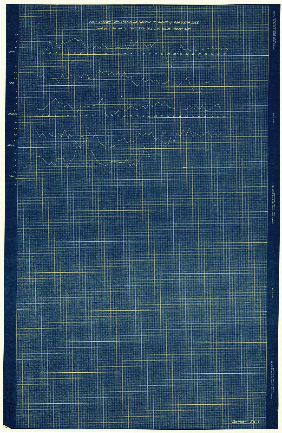
Tide Record Houston Ship Channel by months for year 1935 - Readings at Harrisburg 8 A.M. - 5 P.M.
-
Map/Doc
5995
-
Collection
General Map Collection
-
Object Dates
1935/7/28 (File Date)
1935 (Creation Date)
-
People and Organizations
L.A. McMillian (Surveyor/Engineer)
-
Counties
Galveston
-
Subjects
Surveying Rolled Sketch
-
Height x Width
34.6 x 22.5 inches
87.9 x 57.2 cm
-
Medium
blueprint/diazo
Part of: General Map Collection
Galveston to Rio Grande

Print $20.00
- Digital $50.00
Galveston to Rio Grande
1973
Size 44.2 x 36.8 inches
Map/Doc 69956
Hardeman County Working Sketch 3

Print $20.00
- Digital $50.00
Hardeman County Working Sketch 3
1919
Size 32.7 x 35.1 inches
Map/Doc 63384
Hutchinson County Sketch File 21

Print $22.00
- Digital $50.00
Hutchinson County Sketch File 21
Size 8.8 x 7.9 inches
Map/Doc 27242
Uvalde County Rolled Sketch 10

Print $20.00
- Digital $50.00
Uvalde County Rolled Sketch 10
Size 23.5 x 16.1 inches
Map/Doc 8095
[Map of Sterling County]
![4055, [Map of Sterling County], General Map Collection](https://historictexasmaps.com/wmedia_w700/maps/4055.tif.jpg)
Print $20.00
- Digital $50.00
[Map of Sterling County]
1919
Size 30.2 x 22.8 inches
Map/Doc 4055
Loving County Working Sketch 11

Print $40.00
- Digital $50.00
Loving County Working Sketch 11
1957
Size 21.6 x 50.9 inches
Map/Doc 70644
Flight Mission No. BRA-8M, Frame 69, Jefferson County

Print $20.00
- Digital $50.00
Flight Mission No. BRA-8M, Frame 69, Jefferson County
1953
Size 18.6 x 22.1 inches
Map/Doc 85589
Taylor County Sketch File 19

Print $10.00
- Digital $50.00
Taylor County Sketch File 19
1945
Size 14.2 x 8.8 inches
Map/Doc 37816
Erath County Sketch File 9

Print $4.00
- Digital $50.00
Erath County Sketch File 9
1870
Size 8.2 x 8.4 inches
Map/Doc 22273
Tom Green County Sketch File 89

Print $4.00
Tom Green County Sketch File 89
Size 14.3 x 8.9 inches
Map/Doc 97245
Hardeman County

Print $20.00
- Digital $50.00
Hardeman County
1935
Size 45.1 x 42.2 inches
Map/Doc 1848
Flight Mission No. CLL-1N, Frame 184, Willacy County

Print $20.00
- Digital $50.00
Flight Mission No. CLL-1N, Frame 184, Willacy County
1954
Size 18.4 x 22.1 inches
Map/Doc 87054
You may also like
San Patricio County Sketch File 12

Print $4.00
San Patricio County Sketch File 12
1859
Size 6.6 x 9.9 inches
Map/Doc 36047
Sketch in Dawson County, Texas

Print $3.00
- Digital $50.00
Sketch in Dawson County, Texas
1950
Size 9.5 x 12.8 inches
Map/Doc 92627
[Surveys in the Bexar District along Hondo and Seco Creeks]
![314, [Surveys in the Bexar District along Hondo and Seco Creeks], General Map Collection](https://historictexasmaps.com/wmedia_w700/maps/314.tif.jpg)
Print $3.00
- Digital $50.00
[Surveys in the Bexar District along Hondo and Seco Creeks]
1847
Size 9.3 x 9.9 inches
Map/Doc 314
Flight Mission No. BRA-7M, Frame 80, Jefferson County

Print $20.00
- Digital $50.00
Flight Mission No. BRA-7M, Frame 80, Jefferson County
1953
Size 15.9 x 15.8 inches
Map/Doc 85502
Nueces County Sketch File 11

Print $40.00
- Digital $50.00
Nueces County Sketch File 11
1859
Size 11.2 x 8.6 inches
Map/Doc 32518
The Republic County of Brazoria. January 1, 1838

Print $20.00
The Republic County of Brazoria. January 1, 1838
2020
Size 14.7 x 21.8 inches
Map/Doc 96111
Menard County Rolled Sketch 4

Print $20.00
- Digital $50.00
Menard County Rolled Sketch 4
Size 18.5 x 14.3 inches
Map/Doc 6754
Jefferson Co.

Print $40.00
- Digital $50.00
Jefferson Co.
1978
Size 48.2 x 42.7 inches
Map/Doc 73196
The "Magic Valley" of the Lower Rio Grande - the Land of Golden Fruit

The "Magic Valley" of the Lower Rio Grande - the Land of Golden Fruit
1930
Map/Doc 96745
Concho County Sketch File 22

Print $20.00
- Digital $50.00
Concho County Sketch File 22
Size 24.9 x 18.1 inches
Map/Doc 11155
Flight Mission No. DQN-1K, Frame 141, Calhoun County

Print $20.00
- Digital $50.00
Flight Mission No. DQN-1K, Frame 141, Calhoun County
1953
Size 18.5 x 22.1 inches
Map/Doc 84204
Colorado County Sketch File 16

Print $4.00
- Digital $50.00
Colorado County Sketch File 16
Size 8.2 x 10.3 inches
Map/Doc 18945