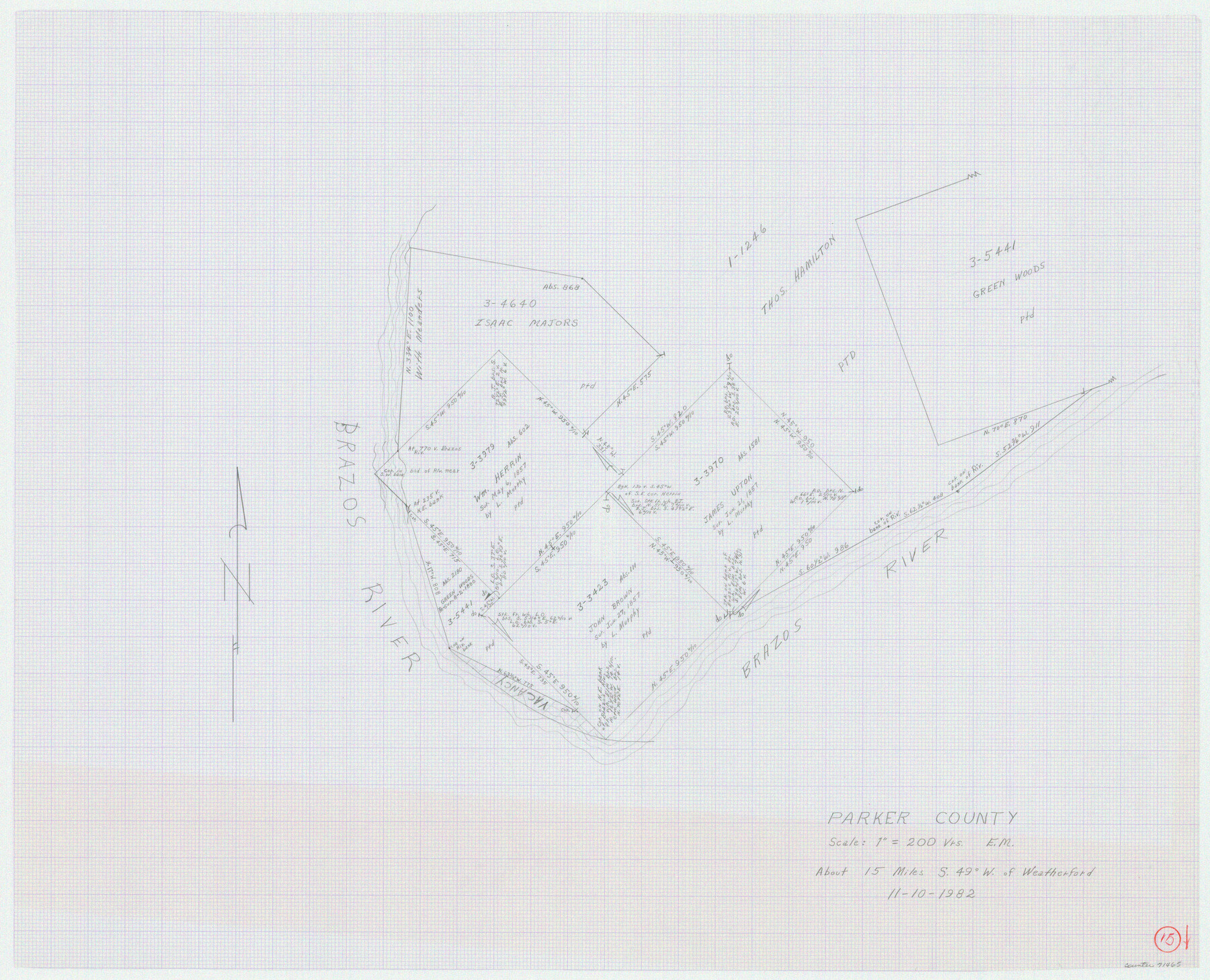
Parker County Working Sketch 15
-
Map/Doc
71465
-
Collection
General Map Collection
-
Object Dates
11/10/1982 (Creation Date)
-
People and Organizations
Elbert Menzel (Draftsman)
-
Counties
Parker
-
Subjects
Surveying Working Sketch
-
Scale
1" = 200 varas
Part of: General Map Collection
Montgomery County Rolled Sketch 29

Print $20.00
- Digital $50.00
Montgomery County Rolled Sketch 29
1948
Size 36.4 x 31.7 inches
Map/Doc 9537

Live Oak County Sketch File 13

Print $17.00
- Digital $50.00
Live Oak County Sketch File 13
1880
Size 10.2 x 13.7 inches
Map/Doc 30270
Red River County Working Sketch 80

Print $20.00
- Digital $50.00
Red River County Working Sketch 80
1982
Size 24.1 x 29.3 inches
Map/Doc 72063

Flight Mission No. CRC-2R, Frame 179, Chambers County

Print $20.00
- Digital $50.00
Flight Mission No. CRC-2R, Frame 179, Chambers County
1956
Size 18.6 x 22.3 inches
Map/Doc 84757
Kleberg County Sketch File 1

Print $36.00
- Digital $50.00
Kleberg County Sketch File 1
1994
Size 8.8 x 11.3 inches
Map/Doc 29192
Sutton County Sketch File 47

Print $4.00
- Digital $50.00
Sutton County Sketch File 47
1939
Size 11.4 x 8.8 inches
Map/Doc 37519
Knox County Sketch File 19

Print $42.00
- Digital $50.00
Knox County Sketch File 19
Size 38.4 x 11.0 inches
Map/Doc 11961
Briscoe County Sketch File O-1

Print $2.00
- Digital $50.00
Briscoe County Sketch File O-1
1935
Size 11.3 x 7.2 inches
Map/Doc 16425
Dimmit County

Print $40.00
- Digital $50.00
Dimmit County
1976
Size 43.2 x 50.7 inches
Map/Doc 73133
Milam County Working Sketch 4

Print $20.00
- Digital $50.00
Milam County Working Sketch 4
1954
Size 26.1 x 32.4 inches
Map/Doc 71019
You may also like
Culberson County Working Sketch 12

Print $20.00
- Digital $50.00
Culberson County Working Sketch 12
1922
Size 20.9 x 17.8 inches
Map/Doc 68464
Sketch showing progress of topographical work Laguna Madre and vicinity from Rainey Is. to Baffins Bay, Coast of Texas Sect. IX [and accompanying letter]
![72961, Sketch showing progress of topographical work Laguna Madre and vicinity from Rainey Is. to Baffins Bay, Coast of Texas Sect. IX [and accompanying letter], General Map Collection](https://historictexasmaps.com/wmedia_w700/maps/72961.tif.jpg)
Print $2.00
- Digital $50.00
Sketch showing progress of topographical work Laguna Madre and vicinity from Rainey Is. to Baffins Bay, Coast of Texas Sect. IX [and accompanying letter]
Size 11.1 x 8.7 inches
Map/Doc 72961
[University Lands Blocks 16-18]
![91568, [University Lands Blocks 16-18], Twichell Survey Records](https://historictexasmaps.com/wmedia_w700/maps/91568-1.tif.jpg)
Print $20.00
- Digital $50.00
[University Lands Blocks 16-18]
Size 18.5 x 12.7 inches
Map/Doc 91568
Montgomery County Sketch File 37

Print $6.00
- Digital $50.00
Montgomery County Sketch File 37
Size 12.6 x 8.2 inches
Map/Doc 31916
Presidio County Rolled Sketch 88

Print $20.00
- Digital $50.00
Presidio County Rolled Sketch 88
1946
Size 34.8 x 29.9 inches
Map/Doc 9780
Right-of-Way and Track Map, Texas State Railroad operated by the T. and N. O. R.R. Co.

Print $40.00
- Digital $50.00
Right-of-Way and Track Map, Texas State Railroad operated by the T. and N. O. R.R. Co.
1917
Size 24.4 x 55.8 inches
Map/Doc 64174
Nueces County Working Sketch 2

Print $20.00
- Digital $50.00
Nueces County Working Sketch 2
1950
Size 42.0 x 15.5 inches
Map/Doc 71304
Sutton County Working Sketch 5

Print $20.00
- Digital $50.00
Sutton County Working Sketch 5
1969
Size 25.4 x 33.4 inches
Map/Doc 62348
Nora Jane Wilson Lease

Print $20.00
- Digital $50.00
Nora Jane Wilson Lease
1952
Size 12.5 x 15.0 inches
Map/Doc 92962
Hutchinson County Sketch File 6

Print $8.00
- Digital $50.00
Hutchinson County Sketch File 6
1890
Size 10.9 x 8.4 inches
Map/Doc 27198
Lavaca County Working Sketch 20

Print $20.00
- Digital $50.00
Lavaca County Working Sketch 20
1980
Size 19.2 x 26.0 inches
Map/Doc 70373
Sabine and Neches Rivers

Print $20.00
- Digital $50.00
Sabine and Neches Rivers
1925
Size 19.6 x 44.0 inches
Map/Doc 69816