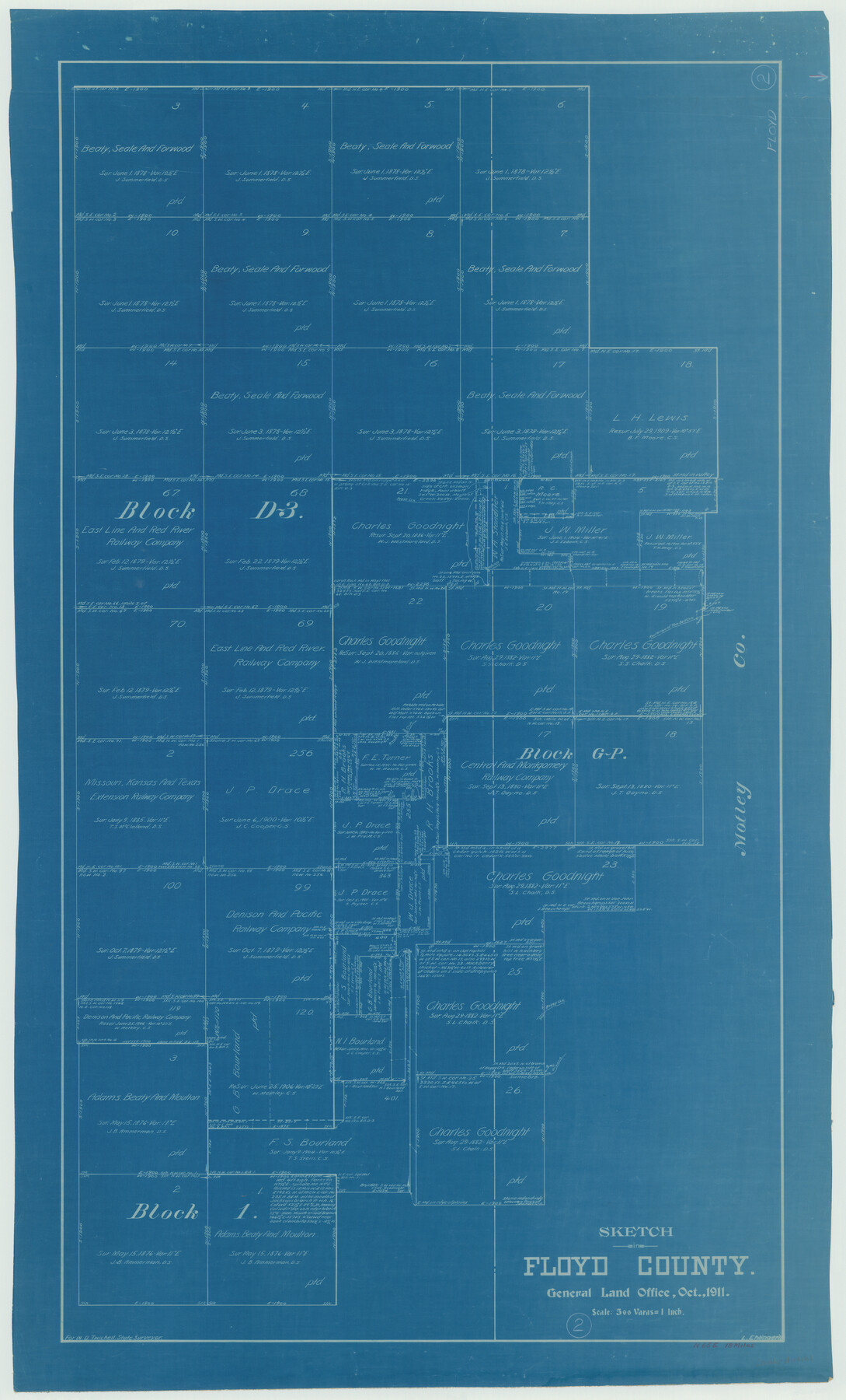
Floyd County Working Sketch 2
-
Map/Doc
69181
-
Collection
General Map Collection
-
Object Dates
10/1911 (Creation Date)
-
People and Organizations
L. Ehlinger (Draftsman)
-
Counties
Floyd Motley
-
Subjects
Surveying Working Sketch
-
Height x Width
41.0 x 24.8 inches
104.1 x 63.0 cm
-
Scale
1" = 500 varas
Part of: General Map Collection
Fort Bend County Sketch File 16 1/2

Print $16.00
- Digital $50.00
Fort Bend County Sketch File 16 1/2
Size 14.3 x 8.8 inches
Map/Doc 22927
Map of Atascosa County, Texas

Print $20.00
- Digital $50.00
Map of Atascosa County, Texas
1916
Size 30.0 x 28.6 inches
Map/Doc 9006
Flight Mission No. BRA-16M, Frame 65, Jefferson County

Print $20.00
- Digital $50.00
Flight Mission No. BRA-16M, Frame 65, Jefferson County
1953
Size 18.7 x 22.4 inches
Map/Doc 85682
Winkler County Sketch File 14

Print $20.00
- Digital $50.00
Winkler County Sketch File 14
Size 29.4 x 24.3 inches
Map/Doc 12698
Roberts County Working Sketch 26

Print $20.00
- Digital $50.00
Roberts County Working Sketch 26
1982
Size 28.5 x 31.6 inches
Map/Doc 63552
Crane County Boundary File 1

Print $6.00
- Digital $50.00
Crane County Boundary File 1
Size 14.1 x 8.7 inches
Map/Doc 51957
Outer Continental Shelf Leasing Maps (Texas Offshore Operations)

Print $20.00
- Digital $50.00
Outer Continental Shelf Leasing Maps (Texas Offshore Operations)
1954
Size 16.2 x 15.7 inches
Map/Doc 75837
Andrews County Rolled Sketch 32

Print $20.00
- Digital $50.00
Andrews County Rolled Sketch 32
1950
Size 26.2 x 16.4 inches
Map/Doc 77176
Duval County Rolled Sketch 17

Print $20.00
- Digital $50.00
Duval County Rolled Sketch 17
1940
Size 18.9 x 17.9 inches
Map/Doc 5738
Duval County Rolled Sketch 30A

Print $40.00
- Digital $50.00
Duval County Rolled Sketch 30A
1896
Size 59.7 x 40.8 inches
Map/Doc 76145
Angelina County Sketch File 15

Print $8.00
- Digital $50.00
Angelina County Sketch File 15
1848
Size 12.5 x 7.5 inches
Map/Doc 12960
Gregg County Sketch File 17

Print $10.00
- Digital $50.00
Gregg County Sketch File 17
1874
Size 10.3 x 8.2 inches
Map/Doc 24621
You may also like
Kendall County Sketch File 22B

Print $20.00
- Digital $50.00
Kendall County Sketch File 22B
1937
Size 19.3 x 24.6 inches
Map/Doc 11911

Dawson County Sketch File 1

Print $6.00
- Digital $50.00
Dawson County Sketch File 1
Size 7.5 x 3.9 inches
Map/Doc 20495
Map of the Country Between the Frontiers of Arkansas and New Mexico embracing the section explored in 1849, 51, and 52

Print $40.00
Map of the Country Between the Frontiers of Arkansas and New Mexico embracing the section explored in 1849, 51, and 52
1852
Size 29.6 x 62.1 inches
Map/Doc 76219
Terrell County Working Sketch 33

Print $20.00
- Digital $50.00
Terrell County Working Sketch 33
1945
Size 16.1 x 31.6 inches
Map/Doc 62125
Frio County Rolled Sketch 19

Print $20.00
- Digital $50.00
Frio County Rolled Sketch 19
1956
Size 35.1 x 40.4 inches
Map/Doc 8909
Bosque County Sketch File 23

Print $6.00
- Digital $50.00
Bosque County Sketch File 23
1863
Size 10.2 x 8.2 inches
Map/Doc 14806
Houston County Rolled Sketch 9

Print $20.00
- Digital $50.00
Houston County Rolled Sketch 9
1980
Size 27.5 x 26.6 inches
Map/Doc 6229
Jefferson County Rolled Sketch 46

Print $2.00
- Digital $50.00
Jefferson County Rolled Sketch 46
1969
Size 12.3 x 5.9 inches
Map/Doc 10198
Lavaca County Sketch File 10

Print $4.00
- Digital $50.00
Lavaca County Sketch File 10
1890
Size 7.5 x 11.5 inches
Map/Doc 29648
Ellis County Sketch File 16

Print $4.00
- Digital $50.00
Ellis County Sketch File 16
Size 13.1 x 8.3 inches
Map/Doc 21858
Harris County Working Sketch 15

Print $20.00
- Digital $50.00
Harris County Working Sketch 15
1916
Size 29.3 x 41.2 inches
Map/Doc 65907