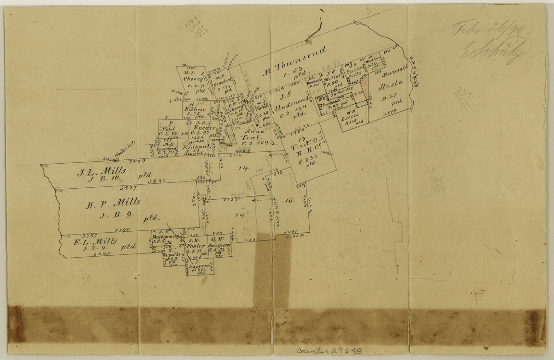
Lavaca County Sketch File 10
[Office sketch southeast of Hallettsville]
-
Map/Doc
29648
-
Collection
General Map Collection
-
Object Dates
2/26/1890 (Creation Date)
2/26/1890 (File Date)
-
Counties
Lavaca
-
Subjects
Surveying Sketch File
-
Height x Width
7.5 x 11.5 inches
19.1 x 29.2 cm
-
Medium
paper, manuscript
Part of: General Map Collection
Ellis County Sketch File 22

Print $2.00
- Digital $50.00
Ellis County Sketch File 22
1857
Size 8.0 x 4.0 inches
Map/Doc 88797
Cochran County Sketch File 4

Print $20.00
- Digital $50.00
Cochran County Sketch File 4
1931
Size 24.9 x 22.1 inches
Map/Doc 11100
Tyler County Sketch File 6

Print $6.00
- Digital $50.00
Tyler County Sketch File 6
1848
Size 6.0 x 7.1 inches
Map/Doc 38630
Sterling County Rolled Sketch 13

Print $20.00
- Digital $50.00
Sterling County Rolled Sketch 13
1945
Size 34.9 x 27.3 inches
Map/Doc 7847
Map of Jefferson County

Print $20.00
- Digital $50.00
Map of Jefferson County
1840
Size 34.8 x 27.0 inches
Map/Doc 3726

Colorado River, Grape Creek Sheet/Proposed Dam Site

Print $4.00
- Digital $50.00
Colorado River, Grape Creek Sheet/Proposed Dam Site
1937
Size 20.1 x 23.8 inches
Map/Doc 65304
Flight Mission No. BRA-7M, Frame 15, Jefferson County

Print $20.00
- Digital $50.00
Flight Mission No. BRA-7M, Frame 15, Jefferson County
1953
Size 18.6 x 22.3 inches
Map/Doc 85466
![94158, Austin Street Map [Recto], General Map Collection](https://historictexasmaps.com/wmedia_w700/maps/94158.tif.jpg)
Map of Chicago, Rock Island & Texas Railway through Montague and Wise Counties, Texas

Print $20.00
- Digital $50.00
Map of Chicago, Rock Island & Texas Railway through Montague and Wise Counties, Texas
1893
Size 19.0 x 47.6 inches
Map/Doc 64469
Pottsboro Quadrangle

Print $20.00
- Digital $50.00
Pottsboro Quadrangle
1999
Size 35.4 x 23.4 inches
Map/Doc 97363
Williamson County Sketch File 14

Print $6.00
- Digital $50.00
Williamson County Sketch File 14
1871
Size 9.4 x 15.4 inches
Map/Doc 40332
You may also like
Harris County Rolled Sketch 91

Print $407.00
- Digital $50.00
Harris County Rolled Sketch 91
1981
Size 31.0 x 24.3 inches
Map/Doc 6130
Milam County Boundary File 3

Print $16.00
- Digital $50.00
Milam County Boundary File 3
Size 13.9 x 8.5 inches
Map/Doc 57213
Comanche County Sketch File 19

Print $12.00
- Digital $50.00
Comanche County Sketch File 19
Size 13.0 x 8.0 inches
Map/Doc 19093
Flight Mission No. DQO-11K, Frame 25, Galveston County

Print $20.00
- Digital $50.00
Flight Mission No. DQO-11K, Frame 25, Galveston County
1952
Size 18.8 x 22.4 inches
Map/Doc 85222
Hamilton County Working Sketch 31

Print $20.00
- Digital $50.00
Hamilton County Working Sketch 31
Size 23.3 x 18.2 inches
Map/Doc 63369
Duval County Rolled Sketch 30A

Print $40.00
- Digital $50.00
Duval County Rolled Sketch 30A
1896
Size 59.7 x 40.8 inches
Map/Doc 76145
Dawson County Working Sketch 19

Print $20.00
- Digital $50.00
Dawson County Working Sketch 19
1963
Size 24.8 x 32.4 inches
Map/Doc 68563
[East Part of Bailey County and West Part of Lamb County]
![91048, [East Part of Bailey County and West Part of Lamb County], Twichell Survey Records](https://historictexasmaps.com/wmedia_w700/maps/91048-1.tif.jpg)
Print $20.00
- Digital $50.00
[East Part of Bailey County and West Part of Lamb County]
Size 22.5 x 18.3 inches
Map/Doc 91048
[East line of Childress County along border of Oklahoma]
![91988, [East line of Childress County along border of Oklahoma], Twichell Survey Records](https://historictexasmaps.com/wmedia_w700/maps/91988-1.tif.jpg)
Print $20.00
- Digital $50.00
[East line of Childress County along border of Oklahoma]
Size 30.1 x 8.6 inches
Map/Doc 91988
Parker County Sketch File 32

Print $6.00
- Digital $50.00
Parker County Sketch File 32
Size 11.0 x 12.2 inches
Map/Doc 33574
Stonewall County Rolled Sketch 22

Print $20.00
- Digital $50.00
Stonewall County Rolled Sketch 22
1951
Size 33.2 x 30.9 inches
Map/Doc 9961
Reagan County Rolled Sketch 32

Print $20.00
- Digital $50.00
Reagan County Rolled Sketch 32
Size 46.3 x 38.5 inches
Map/Doc 9827