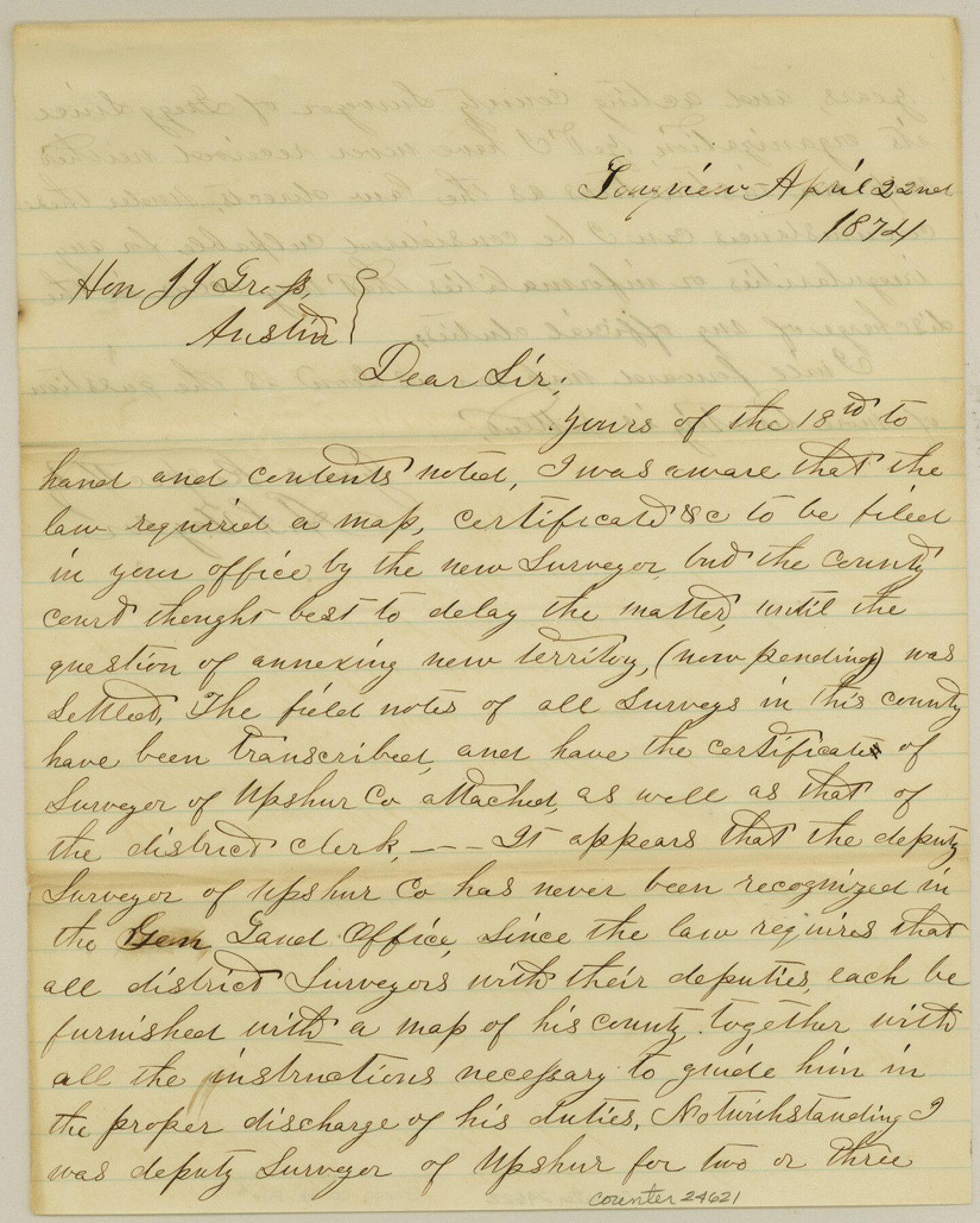
Gregg County Sketch File 17
[County Surveyor report and certificates on county records]
-
Map/Doc
24621
-
Collection
General Map Collection
-
Object Dates
1874/4/22 (Creation Date)
1874/4/25 (File Date)
-
People and Organizations
A.S. Taylor (Surveyor/Engineer)
-
Counties
Gregg Upshur
-
Subjects
Surveying Sketch File
-
Height x Width
10.3 x 8.2 inches
26.2 x 20.8 cm
-
Medium
paper, manuscript
Part of: General Map Collection
Navarro County Working Sketch 13
![71243, Navarro County Working Sketch 13, General Map Collection](https://historictexasmaps.com/wmedia_w700/maps/71243.tif.jpg)
Print $20.00
- Digital $50.00
Navarro County Working Sketch 13
Size 15.6 x 16.1 inches
Map/Doc 71243
Crockett County Rolled Sketch S
![5639, Crockett County Rolled Sketch S, General Map Collection](https://historictexasmaps.com/wmedia_w700/maps/5639.tif.jpg)
Print $20.00
- Digital $50.00
Crockett County Rolled Sketch S
Size 8.3 x 21.2 inches
Map/Doc 5639
Hale County Working Sketch 4
![63324, Hale County Working Sketch 4, General Map Collection](https://historictexasmaps.com/wmedia_w700/maps/63324.tif.jpg)
Print $4.00
- Digital $50.00
Hale County Working Sketch 4
Size 22.7 x 18.7 inches
Map/Doc 63324
A New Map of the Whole Continent of America. Divided into North and South and West Indies, wherein are exactly decribed the United States of North America as well as the Several European Possessions according to the Preliminaries of Peace…
![95137, A New Map of the Whole Continent of America. Divided into North and South and West Indies, wherein are exactly decribed the United States of North America as well as the Several European Possessions according to the Preliminaries of Peace…, General Map Collection](https://historictexasmaps.com/wmedia_w700/maps/95137.tif.jpg)
Print $40.00
- Digital $50.00
A New Map of the Whole Continent of America. Divided into North and South and West Indies, wherein are exactly decribed the United States of North America as well as the Several European Possessions according to the Preliminaries of Peace…
Size 42.8 x 48.8 inches
Map/Doc 95137
Right of Way and Track Map Texas & New Orleans R.R. Co. operated by the T. & N. O. R.R. Co. Dallas-Sabine Branch
![64153, Right of Way and Track Map Texas & New Orleans R.R. Co. operated by the T. & N. O. R.R. Co. Dallas-Sabine Branch, General Map Collection](https://historictexasmaps.com/wmedia_w700/maps/64153.tif.jpg)
Print $40.00
- Digital $50.00
Right of Way and Track Map Texas & New Orleans R.R. Co. operated by the T. & N. O. R.R. Co. Dallas-Sabine Branch
1918
Size 26.1 x 57.1 inches
Map/Doc 64153
San Augustine County Working Sketch 13
![63701, San Augustine County Working Sketch 13, General Map Collection](https://historictexasmaps.com/wmedia_w700/maps/63701.tif.jpg)
Print $20.00
- Digital $50.00
San Augustine County Working Sketch 13
Size 34.0 x 27.6 inches
Map/Doc 63701
Colorado River, Buecher State Park
![65324, Colorado River, Buecher State Park, General Map Collection](https://historictexasmaps.com/wmedia_w700/maps/65324.tif.jpg)
Print $4.00
- Digital $50.00
Colorado River, Buecher State Park
1934
Size 20.8 x 11.6 inches
Map/Doc 65324
[Surveys in Austin's Colony by Horatio Chriesman along Mill and Cummins Creeks]
![68, [Surveys in Austin's Colony by Horatio Chriesman along Mill and Cummins Creeks], General Map Collection](https://historictexasmaps.com/wmedia_w700/maps/68.tif.jpg)
Print $20.00
- Digital $50.00
[Surveys in Austin's Colony by Horatio Chriesman along Mill and Cummins Creeks]
1830
Size 30.7 x 25.7 inches
Map/Doc 68
Red River County Working Sketch 33
![72016, Red River County Working Sketch 33, General Map Collection](https://historictexasmaps.com/wmedia_w700/maps/72016.tif.jpg)
Print $20.00
- Digital $50.00
Red River County Working Sketch 33
Size 47.0 x 22.2 inches
Map/Doc 72016
Brewster County Rolled Sketch 154
![5325, Brewster County Rolled Sketch 154, General Map Collection](https://historictexasmaps.com/wmedia_w700/maps/5325.tif.jpg)
Print $20.00
- Digital $50.00
Brewster County Rolled Sketch 154
2001
Size 36.3 x 28.0 inches
Map/Doc 5325
Map of Presidio County, Texas
![76071, Map of Presidio County, Texas, General Map Collection](https://historictexasmaps.com/wmedia_w700/maps/76071.tif.jpg)
Print $40.00
- Digital $50.00
Map of Presidio County, Texas
Size 42.6 x 86.0 inches
Map/Doc 76071
Starr County Rolled Sketch 34
![7831, Starr County Rolled Sketch 34, General Map Collection](https://historictexasmaps.com/wmedia_w700/maps/7831.tif.jpg)
Print $20.00
- Digital $50.00
Starr County Rolled Sketch 34
1945
Size 20.8 x 17.9 inches
Map/Doc 7831
You may also like
Matagorda County NRC Article 33.136 Sketch 11
![94465, Matagorda County NRC Article 33.136 Sketch 11, General Map Collection](https://historictexasmaps.com/wmedia_w700/pdf_converted_jpg/qi_pdf_thumbnail_39102.jpg)
Print $42.00
- Digital $50.00
Matagorda County NRC Article 33.136 Sketch 11
Size 18.0 x 24.0 inches
Map/Doc 94465
Webb County Sketch File 11a-1
![12626, Webb County Sketch File 11a-1, General Map Collection](https://historictexasmaps.com/wmedia_w700/pdf_converted_jpg/qi_pdf_thumbnail_8896.jpg)
Print $27.00
- Digital $50.00
Webb County Sketch File 11a-1
1884
Size 22.2 x 9.3 inches
Map/Doc 12626
Red River County Sketch File 5a
![35104, Red River County Sketch File 5a, General Map Collection](https://historictexasmaps.com/wmedia_w700/pdf_converted_jpg/qi_pdf_thumbnail_13839.jpg)
Print $2.00
- Digital $50.00
Red River County Sketch File 5a
Size 4.7 x 6.6 inches
Map/Doc 35104
Right of Way and Track Map Texas & New Orleans R.R. Co. operated by the T. & N. O. R.R. Co. Dallas-Sabine Branch
![64154, Right of Way and Track Map Texas & New Orleans R.R. Co. operated by the T. & N. O. R.R. Co. Dallas-Sabine Branch, General Map Collection](https://historictexasmaps.com/wmedia_w700/maps/64154.tif.jpg)
Print $40.00
- Digital $50.00
Right of Way and Track Map Texas & New Orleans R.R. Co. operated by the T. & N. O. R.R. Co. Dallas-Sabine Branch
1918
Size 26.4 x 56.7 inches
Map/Doc 64154
[Map Showing Estivan Martinez "Los Nerios de Tio Ayola" Survey and Surveys North Thereof, Brooks County, Texas]
![10755, [Map Showing Estivan Martinez "Los Nerios de Tio Ayola" Survey and Surveys North Thereof, Brooks County, Texas], Maddox Collection](https://historictexasmaps.com/wmedia_w700/maps/10755.tif.jpg)
Print $20.00
- Digital $50.00
[Map Showing Estivan Martinez "Los Nerios de Tio Ayola" Survey and Surveys North Thereof, Brooks County, Texas]
1906
Size 16.7 x 25.1 inches
Map/Doc 10755
Presidio County Rolled Sketch 44
![7341, Presidio County Rolled Sketch 44, General Map Collection](https://historictexasmaps.com/wmedia_w700/maps/7341.tif.jpg)
Print $20.00
- Digital $50.00
Presidio County Rolled Sketch 44
1907
Size 14.3 x 25.3 inches
Map/Doc 7341
Hudspeth County Rolled Sketch 69
![7717, Hudspeth County Rolled Sketch 69, General Map Collection](https://historictexasmaps.com/wmedia_w700/maps/7717.tif.jpg)
Print $20.00
- Digital $50.00
Hudspeth County Rolled Sketch 69
1973
Size 12.2 x 20.8 inches
Map/Doc 7717
Armstrong County Sketch File A-9
![10851, Armstrong County Sketch File A-9, General Map Collection](https://historictexasmaps.com/wmedia_w700/pdf_converted_jpg/qi_pdf_thumbnail_7439.jpg)
Print $40.00
- Digital $50.00
Armstrong County Sketch File A-9
1920
Size 13.7 x 35.4 inches
Map/Doc 10851
[Jacob Masters league and those adjoining and Surveys on Elkhart Creek]
![183, [Jacob Masters league and those adjoining and Surveys on Elkhart Creek], General Map Collection](https://historictexasmaps.com/wmedia_w700/maps/183.tif.jpg)
Print $20.00
- Digital $50.00
[Jacob Masters league and those adjoining and Surveys on Elkhart Creek]
1846
Size 20.3 x 8.0 inches
Map/Doc 183
[Northeast Portion of Hartley County]
![91118, [Northeast Portion of Hartley County], Twichell Survey Records](https://historictexasmaps.com/wmedia_w700/maps/91118-1.tif.jpg)
Print $2.00
- Digital $50.00
[Northeast Portion of Hartley County]
Size 13.9 x 8.5 inches
Map/Doc 91118
Hemphill County Working Sketch 7
![66102, Hemphill County Working Sketch 7, General Map Collection](https://historictexasmaps.com/wmedia_w700/maps/66102.tif.jpg)
Print $20.00
- Digital $50.00
Hemphill County Working Sketch 7
Size 41.1 x 46.8 inches
Map/Doc 66102
General Highway Map, Liberty County, Texas
![79570, General Highway Map, Liberty County, Texas, Texas State Library and Archives](https://historictexasmaps.com/wmedia_w700/maps/79570.tif.jpg)
Print $20.00
General Highway Map, Liberty County, Texas
1961
Size 18.2 x 24.7 inches
Map/Doc 79570