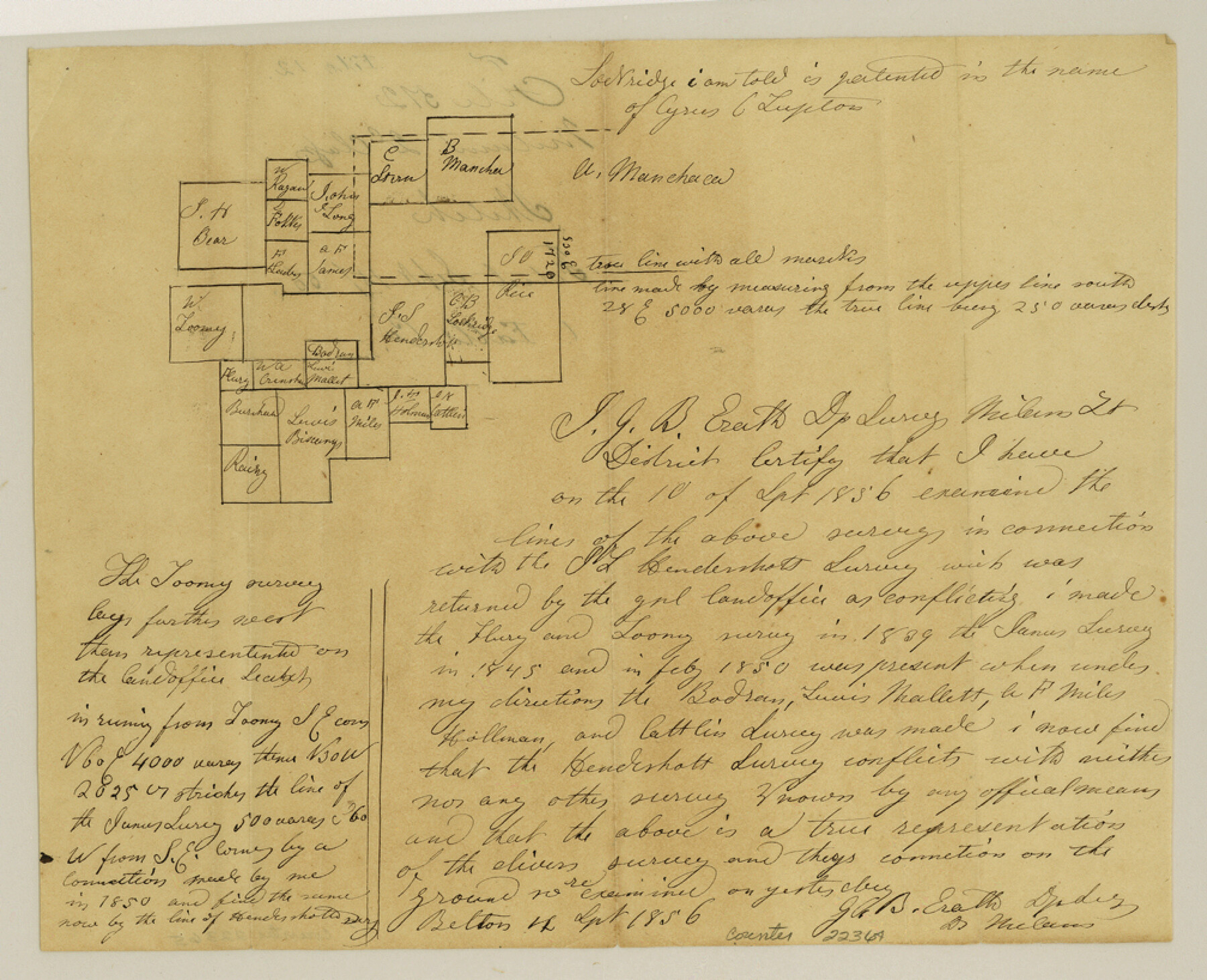
Falls County Sketch File 12
[Office sketch of surveys on Live Oak Creek]
-
Map/Doc
22364
-
Collection
General Map Collection
-
Object Dates
1870/4/19 (Creation Date)
1856/9/15 (File Date)
-
People and Organizations
Thielepape (Draftsman)
-
Counties
Falls
-
Subjects
Surveying Sketch File
-
Height x Width
8.2 x 10.1 inches
20.8 x 25.7 cm
-
Medium
paper, manuscript
-
Features
[Live Oak Creek]
Part of: General Map Collection
Brewster County Rolled Sketch 157

Print $20.00
- Digital $50.00
Brewster County Rolled Sketch 157
2008
Size 36.6 x 24.8 inches
Map/Doc 88870
Blanco County Rolled Sketch 5

Print $20.00
- Digital $50.00
Blanco County Rolled Sketch 5
Size 15.6 x 17.0 inches
Map/Doc 5143
Terrell County Rolled Sketch 43

Print $20.00
- Digital $50.00
Terrell County Rolled Sketch 43
1950
Size 27.5 x 36.4 inches
Map/Doc 7946
[Beaumont, Sour Lake and Western Ry. Right of Way and Alignment - Frisco]
![64116, [Beaumont, Sour Lake and Western Ry. Right of Way and Alignment - Frisco], General Map Collection](https://historictexasmaps.com/wmedia_w700/maps/64116.tif.jpg)
Print $20.00
- Digital $50.00
[Beaumont, Sour Lake and Western Ry. Right of Way and Alignment - Frisco]
1910
Size 20.3 x 46.1 inches
Map/Doc 64116
Flight Mission No. DQN-3K, Frame 32, Calhoun County

Print $20.00
- Digital $50.00
Flight Mission No. DQN-3K, Frame 32, Calhoun County
1953
Size 18.6 x 22.3 inches
Map/Doc 84345

Map of Hardin County

Print $20.00
- Digital $50.00
Map of Hardin County
1902
Size 40.8 x 43.9 inches
Map/Doc 4971
Fayette County

Print $40.00
- Digital $50.00
Fayette County
1978
Size 43.6 x 56.1 inches
Map/Doc 95496
Freestone County Working Sketch 11

Print $40.00
- Digital $50.00
Freestone County Working Sketch 11
1978
Size 31.4 x 51.4 inches
Map/Doc 69253
Bosque County, Milam District

Print $20.00
- Digital $50.00
Bosque County, Milam District
1876
Size 24.0 x 29.1 inches
Map/Doc 1519

Denton County Sketch File 28

Print $4.00
- Digital $50.00
Denton County Sketch File 28
Size 14.4 x 8.9 inches
Map/Doc 20756
You may also like
Harris County

Print $20.00
- Digital $50.00
Harris County
1940
Size 36.8 x 45.2 inches
Map/Doc 77304
Webb County Sketch File 52

Print $40.00
- Digital $50.00
Webb County Sketch File 52
1939
Size 14.2 x 16.7 inches
Map/Doc 39839
Freestone County Rolled Sketch 11

Print $20.00
- Digital $50.00
Freestone County Rolled Sketch 11
Size 23.3 x 33.9 inches
Map/Doc 5912
Greer County Sketch File 12

Print $20.00
- Digital $50.00
Greer County Sketch File 12
Size 23.6 x 20.1 inches
Map/Doc 11585
Right of Way and Track Map Texas & New Orleans R.R. Co. operated by the T. & N. O. R.R. Co. Dallas-Sabine Branch

Print $40.00
- Digital $50.00
Right of Way and Track Map Texas & New Orleans R.R. Co. operated by the T. & N. O. R.R. Co. Dallas-Sabine Branch
1918
Size 26.4 x 56.6 inches
Map/Doc 64152
![91316, [Loving County], Twichell Survey Records](https://historictexasmaps.com/wmedia_w700/maps/91316-1.tif.jpg)
Map of the Texas and Pacific Railway and Connections

Print $20.00
Map of the Texas and Pacific Railway and Connections
1897
Size 19.3 x 24.4 inches
Map/Doc 79328
Thorn Empresario Colony. April 25, 1825

Print $20.00
Thorn Empresario Colony. April 25, 1825
2020
Size 17.0 x 21.7 inches
Map/Doc 96006
General Highway Map, Burnet County, Texas

Print $20.00
General Highway Map, Burnet County, Texas
1961
Size 18.0 x 24.6 inches
Map/Doc 79392
Stephens County Working Sketch 21

Print $20.00
- Digital $50.00
Stephens County Working Sketch 21
1975
Size 34.7 x 31.9 inches
Map/Doc 63964
Brewster County Rolled Sketch 101

Print $40.00
- Digital $50.00
Brewster County Rolled Sketch 101
1927
Size 74.4 x 42.4 inches
Map/Doc 9196
Upton County Working Sketch 26

Print $20.00
- Digital $50.00
Upton County Working Sketch 26
1953
Size 29.5 x 17.6 inches
Map/Doc 69522