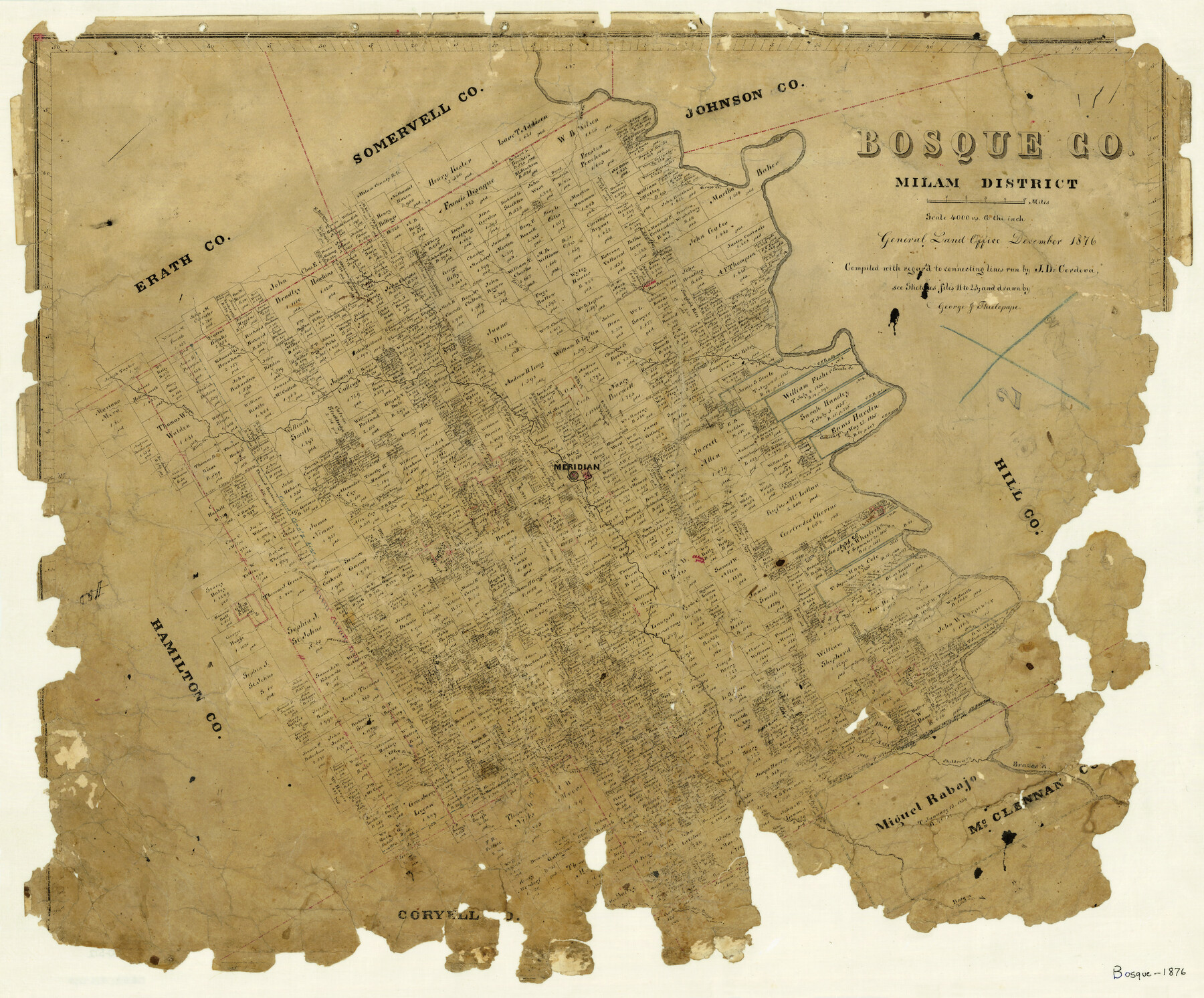
Bosque County, Milam District
-
Map/Doc
1519
-
Collection
General Map Collection
-
Object Dates
12/1876 (Creation Date)
-
People and Organizations
Texas General Land Office (Publisher)
George J. Thielepape (Draftsman)
-
Counties
Bosque
-
Subjects
County
-
Height x Width
24.0 x 29.1 inches
61.0 x 73.9 cm
-
Features
Rocky Creek
Middle Bosque River
Brazos River
Childress Creek
South Fork of Neel Creek
North Fork of Neel Creek
Neel Creek
Cary Creek
Meridian Creek
Mill Creek
East Meridian Creek
Hill Creek
Meridian
Spring Creek
Honey Creek
Bosque River
Cedron Creek
Duffou [sic] Creek
Steele Creek
Mosquito Creek
East Bosque River
Part of: General Map Collection
San Augustine County Sketch File 6

Print $4.00
San Augustine County Sketch File 6
1858
Size 6.4 x 7.7 inches
Map/Doc 35644
Flight Mission No. CLL-3N, Frame 9, Willacy County

Print $20.00
- Digital $50.00
Flight Mission No. CLL-3N, Frame 9, Willacy County
1954
Size 18.5 x 22.3 inches
Map/Doc 87075
Nueces County Sketch File 75

Print $20.00
- Digital $50.00
Nueces County Sketch File 75
1977
Size 26.1 x 27.8 inches
Map/Doc 42199
Reagan County Working Sketch 14c

Print $20.00
- Digital $50.00
Reagan County Working Sketch 14c
Size 20.8 x 9.4 inches
Map/Doc 71856
[Surveys in the Montgomery District: San Jacinto River and Caney Creek, Navidad, Navasota]
![69744, [Surveys in the Montgomery District: San Jacinto River and Caney Creek, Navidad, Navasota], General Map Collection](https://historictexasmaps.com/wmedia_w700/maps/69744.tif.jpg)
Print $2.00
- Digital $50.00
[Surveys in the Montgomery District: San Jacinto River and Caney Creek, Navidad, Navasota]
Size 5.1 x 7.3 inches
Map/Doc 69744
Wilbarger County Sketch File 6

Print $6.00
- Digital $50.00
Wilbarger County Sketch File 6
1874
Size 12.6 x 7.8 inches
Map/Doc 40172
Knox County Sketch File 23

Print $20.00
- Digital $50.00
Knox County Sketch File 23
1931
Size 21.4 x 15.3 inches
Map/Doc 11963
Atascosa County Rolled Sketch 12

Print $40.00
- Digital $50.00
Atascosa County Rolled Sketch 12
1944
Size 33.3 x 68.8 inches
Map/Doc 8429
Aransas County Rolled Sketch 16

Print $40.00
- Digital $50.00
Aransas County Rolled Sketch 16
1965
Size 49.9 x 97.2 inches
Map/Doc 9004
Plan of the City of Galveston, Texas

Print $20.00
- Digital $50.00
Plan of the City of Galveston, Texas
1845
Size 18.2 x 27.4 inches
Map/Doc 62969
Andrews County Working Sketch 1

Print $20.00
- Digital $50.00
Andrews County Working Sketch 1
1946
Size 40.4 x 37.3 inches
Map/Doc 67047
Moore County Sketch File 6

Print $16.00
- Digital $50.00
Moore County Sketch File 6
1902
Size 7.3 x 8.6 inches
Map/Doc 31939
You may also like
America Septentrionalis

Print $20.00
- Digital $50.00
America Septentrionalis
1646
Size 20.0 x 23.4 inches
Map/Doc 93817
Rusk County Working Sketch 37b

Print $40.00
- Digital $50.00
Rusk County Working Sketch 37b
2007
Size 50.0 x 31.0 inches
Map/Doc 87497
Red River County Working Sketch 15

Print $20.00
- Digital $50.00
Red River County Working Sketch 15
1953
Size 25.8 x 23.4 inches
Map/Doc 71998
Delta County, Texas

Print $20.00
- Digital $50.00
Delta County, Texas
1884
Size 14.1 x 20.0 inches
Map/Doc 416
[Unidentified Railroad through Denton and Dallas County]
![64774, [Unidentified Railroad through Denton and Dallas County], General Map Collection](https://historictexasmaps.com/wmedia_w700/maps/64774.tif.jpg)
Print $40.00
- Digital $50.00
[Unidentified Railroad through Denton and Dallas County]
Size 6.8 x 121.3 inches
Map/Doc 64774
[Blocks T1, T2, T3, and Vicinity]
![90983, [Blocks T1, T2, T3, and Vicinity], Twichell Survey Records](https://historictexasmaps.com/wmedia_w700/maps/90983-1.tif.jpg)
Print $20.00
- Digital $50.00
[Blocks T1, T2, T3, and Vicinity]
Size 30.3 x 33.6 inches
Map/Doc 90983
Flight Mission No. BQR-3K, Frame 163, Brazoria County

Print $20.00
- Digital $50.00
Flight Mission No. BQR-3K, Frame 163, Brazoria County
1952
Size 18.7 x 22.3 inches
Map/Doc 83990
Tarrant County Working Sketch 16

Print $20.00
- Digital $50.00
Tarrant County Working Sketch 16
1991
Size 14.5 x 23.9 inches
Map/Doc 62433
Tarrant County Sketch File 6

Print $4.00
- Digital $50.00
Tarrant County Sketch File 6
1859
Size 6.8 x 8.3 inches
Map/Doc 37682
Fort Bend County State Real Property Sketch 16

Print $20.00
- Digital $50.00
Fort Bend County State Real Property Sketch 16
2004
Size 47.9 x 36.5 inches
Map/Doc 80139
Map of the United States and Canada

Print $2.00
- Digital $50.00
Map of the United States and Canada
1853
Size 6.2 x 4.2 inches
Map/Doc 93919
Erath County Sketch File 11

Print $4.00
- Digital $50.00
Erath County Sketch File 11
1871
Size 12.8 x 8.1 inches
Map/Doc 22279