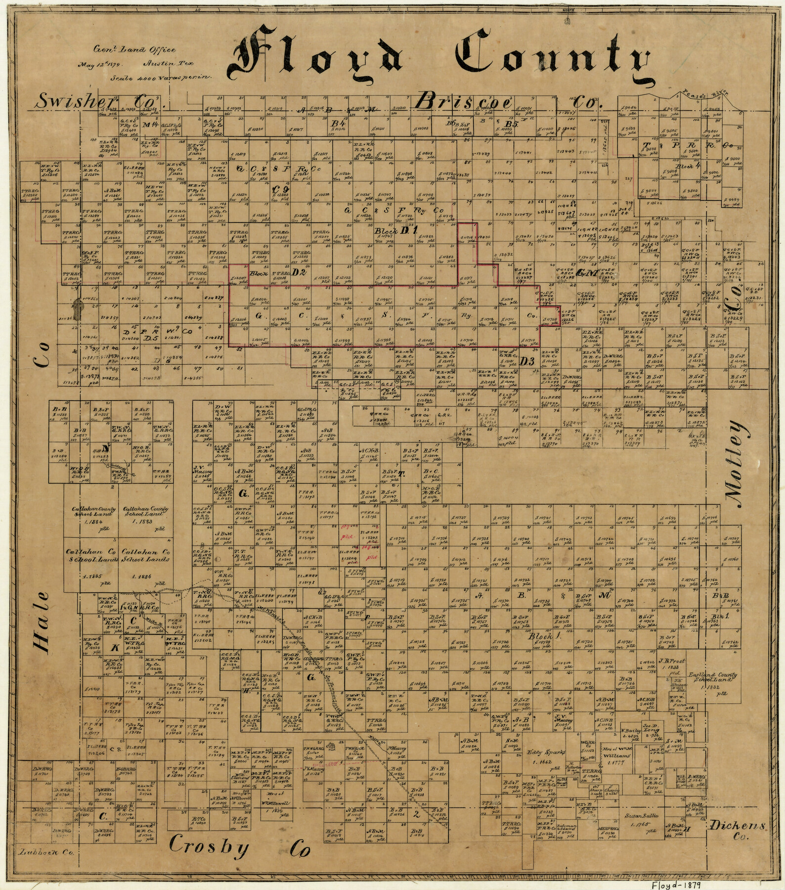
Floyd County
-
Map/Doc
3542
-
Collection
General Map Collection
-
Object Dates
5/12/1879 (Creation Date)
-
Counties
Floyd
-
Subjects
County
-
Height x Width
20.3 x 18.0 inches
51.6 x 45.7 cm
-
Features
Goddard Creek
McKenzie's Trail
Cochran Peak
Pease's [sic] River
White River
Part of: General Map Collection
Gaines County Rolled Sketch 10

Print $20.00
- Digital $50.00
Gaines County Rolled Sketch 10
1905
Size 16.4 x 35.8 inches
Map/Doc 5930
Tyler County Sketch File 14

Print $4.00
- Digital $50.00
Tyler County Sketch File 14
1857
Size 8.3 x 10.1 inches
Map/Doc 38656
Presidio County Working Sketch 55

Print $20.00
- Digital $50.00
Presidio County Working Sketch 55
1955
Size 22.0 x 16.9 inches
Map/Doc 71732
El Paso County Working Sketch Graphic Index - south part

Print $20.00
- Digital $50.00
El Paso County Working Sketch Graphic Index - south part
1977
Size 33.4 x 44.9 inches
Map/Doc 76537
Duval County Working Sketch 7

Print $20.00
- Digital $50.00
Duval County Working Sketch 7
1935
Size 24.4 x 25.0 inches
Map/Doc 68720

Coke County Sketch File 4

Print $46.00
- Digital $50.00
Coke County Sketch File 4
1884
Size 9.2 x 7.7 inches
Map/Doc 18566
Presidio County Working Sketch 29

Print $20.00
- Digital $50.00
Presidio County Working Sketch 29
1946
Size 40.0 x 36.6 inches
Map/Doc 71705
Brewster County Sketch File NS-15

Print $40.00
- Digital $50.00
Brewster County Sketch File NS-15
1977
Size 16.7 x 14.4 inches
Map/Doc 16298
Presidio County Sketch File 14

Print $52.00
- Digital $50.00
Presidio County Sketch File 14
1883
Size 15.3 x 18.8 inches
Map/Doc 11707
Clay County Rolled Sketch 2

Print $20.00
- Digital $50.00
Clay County Rolled Sketch 2
1940
Size 35.9 x 26.8 inches
Map/Doc 5485
[Abstract Numbering Register - Kaufman through Reagan]
![82967, [Abstract Numbering Register - Kaufman through Reagan], General Map Collection](https://historictexasmaps.com/wmedia_w700/pdf_converted_jpg/qi_pdf_thumbnail_30614.jpg)
[Abstract Numbering Register - Kaufman through Reagan]
Map/Doc 82967
You may also like
Fannin County Boundary File 9

Print $14.00
- Digital $50.00
Fannin County Boundary File 9
Size 13.2 x 8.8 inches
Map/Doc 53318
Zavala County Sketch File 11

Print $4.00
- Digital $50.00
Zavala County Sketch File 11
1885
Size 14.4 x 8.8 inches
Map/Doc 41270
Flight Mission No. DAG-17K, Frame 73, Matagorda County

Print $20.00
- Digital $50.00
Flight Mission No. DAG-17K, Frame 73, Matagorda County
1952
Size 18.5 x 22.4 inches
Map/Doc 86332
[Sketch Showing Wm. T. Brewer, John R. Taylor, Wm. F. Butler, Timothy DeVore, L. M. Thorn and adjoining surveys]
![90121, [Sketch Showing Wm. T. Brewer, John R. Taylor, Wm. F. Butler, Timothy DeVore, L. M. Thorn and adjoining surveys], Twichell Survey Records](https://historictexasmaps.com/wmedia_w700/maps/90121-1.tif.jpg)
Print $20.00
- Digital $50.00
[Sketch Showing Wm. T. Brewer, John R. Taylor, Wm. F. Butler, Timothy DeVore, L. M. Thorn and adjoining surveys]
Size 27.2 x 19.3 inches
Map/Doc 90121
Sabine Pass and mouth of the River Sabine in the sea

Print $20.00
- Digital $50.00
Sabine Pass and mouth of the River Sabine in the sea
1840
Size 23.8 x 19.0 inches
Map/Doc 94268
El Paso County

Print $40.00
- Digital $50.00
El Paso County
1881
Size 52.6 x 42.4 inches
Map/Doc 89058
Starr County Sketch File 47

Print $6.00
- Digital $50.00
Starr County Sketch File 47
1949
Size 11.2 x 8.8 inches
Map/Doc 37002
Fayette County Working Sketch 9

Print $20.00
- Digital $50.00
Fayette County Working Sketch 9
1981
Size 34.4 x 32.3 inches
Map/Doc 69173
Acts of the Visit of the Royal Commissioners (sometimes referred to as the “Visita General”) - Laredo

Acts of the Visit of the Royal Commissioners (sometimes referred to as the “Visita General”) - Laredo
1797
Size 14.1 x 9.3 inches
Map/Doc 94256
Briscoe County Sketch File K

Print $40.00
- Digital $50.00
Briscoe County Sketch File K
1920
Size 31.9 x 21.0 inches
Map/Doc 11008
[Map of Encinal County]
![3517, [Map of Encinal County], General Map Collection](https://historictexasmaps.com/wmedia_w700/maps/3517-1.tif.jpg)
Print $20.00
- Digital $50.00
[Map of Encinal County]
1872
Size 27.9 x 21.9 inches
Map/Doc 3517
[Sketch showing subdivisions of Leagues 7-10]
![89850, [Sketch showing subdivisions of Leagues 7-10], Twichell Survey Records](https://historictexasmaps.com/wmedia_w700/maps/89850-2.tif.jpg)
Print $20.00
- Digital $50.00
[Sketch showing subdivisions of Leagues 7-10]
1956
Size 36.6 x 39.4 inches
Map/Doc 89850