Clay County Rolled Sketch 2
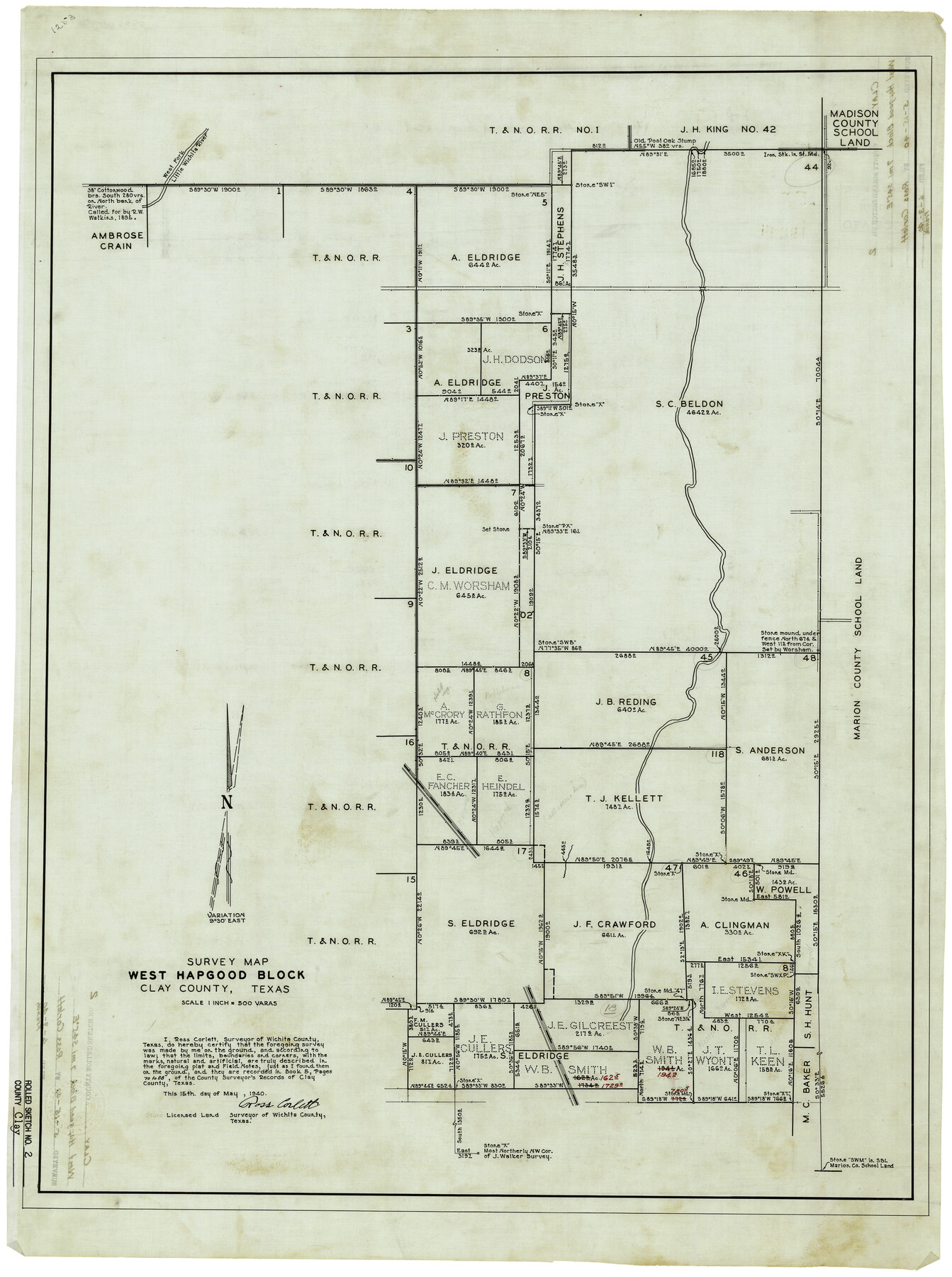
Survey map, West Hapgood Block, Clay County, Texas
-
Map/Doc
5485
-
Collection
General Map Collection
-
Object Dates
5/15/1940 (Creation Date)
6/3/1940 (File Date)
-
People and Organizations
Ross Corlett (Surveyor/Engineer)
-
Counties
Clay
-
Subjects
Surveying Rolled Sketch
-
Height x Width
35.9 x 26.8 inches
91.2 x 68.1 cm
-
Medium
linen, manuscript
-
Scale
1" = 500 varas
Part of: General Map Collection
Flight Mission No. CRC-5R, Frame 22, Chambers County

Print $20.00
- Digital $50.00
Flight Mission No. CRC-5R, Frame 22, Chambers County
1956
Size 18.7 x 22.6 inches
Map/Doc 84944
San Patricio County

Print $40.00
- Digital $50.00
San Patricio County
1939
Size 39.3 x 48.3 inches
Map/Doc 73283
Gaines County Working Sketch 8

Print $20.00
- Digital $50.00
Gaines County Working Sketch 8
1951
Size 21.8 x 24.8 inches
Map/Doc 69308
Knox County Sketch File 2

Print $40.00
- Digital $50.00
Knox County Sketch File 2
1872
Size 26.5 x 38.0 inches
Map/Doc 76758
Jeff Davis County Working Sketch 24

Print $40.00
- Digital $50.00
Jeff Davis County Working Sketch 24
1958
Size 24.9 x 52.9 inches
Map/Doc 66519
[St. L. S-W. Ry. Of Texas Map of Lufkin Branch in Cherokee County Texas]
![64021, [St. L. S-W. Ry. Of Texas Map of Lufkin Branch in Cherokee County Texas], General Map Collection](https://historictexasmaps.com/wmedia_w700/maps/64021.tif.jpg)
Print $40.00
- Digital $50.00
[St. L. S-W. Ry. Of Texas Map of Lufkin Branch in Cherokee County Texas]
1912
Size 23.4 x 124.3 inches
Map/Doc 64021
Flight Mission No. DQN-1K, Frame 129, Calhoun County

Print $20.00
- Digital $50.00
Flight Mission No. DQN-1K, Frame 129, Calhoun County
1953
Size 18.5 x 22.2 inches
Map/Doc 84192
Map of Upshur County Showing Location T&P R.

Print $20.00
- Digital $50.00
Map of Upshur County Showing Location T&P R.
1872
Size 26.5 x 19.4 inches
Map/Doc 64137
Lipscomb County Working Sketch 7

Print $20.00
- Digital $50.00
Lipscomb County Working Sketch 7
1982
Size 42.7 x 21.4 inches
Map/Doc 70583
Flight Mission No. CGI-1N, Frame 140, Cameron County

Print $20.00
- Digital $50.00
Flight Mission No. CGI-1N, Frame 140, Cameron County
1955
Size 18.7 x 22.3 inches
Map/Doc 84496
Trinity River, South Extension Porters Bluff Sheet

Print $20.00
- Digital $50.00
Trinity River, South Extension Porters Bluff Sheet
1925
Size 16.3 x 24.4 inches
Map/Doc 69690
Pecos County Rolled Sketch 121

Print $20.00
- Digital $50.00
Pecos County Rolled Sketch 121
Size 21.8 x 23.4 inches
Map/Doc 7262
You may also like
Moore County Rolled Sketch 6

Print $20.00
- Digital $50.00
Moore County Rolled Sketch 6
1911
Size 33.4 x 30.2 inches
Map/Doc 6825
Hudspeth County Rolled Sketch 14

Print $20.00
- Digital $50.00
Hudspeth County Rolled Sketch 14
1885
Size 17.1 x 35.9 inches
Map/Doc 9202
Ector County Working Sketch 29

Print $40.00
- Digital $50.00
Ector County Working Sketch 29
1971
Size 43.9 x 63.4 inches
Map/Doc 68872
Crosby County Working Sketch 15

Print $20.00
- Digital $50.00
Crosby County Working Sketch 15
1977
Size 34.0 x 35.9 inches
Map/Doc 68449
Liberty County Working Sketch 10

Print $40.00
- Digital $50.00
Liberty County Working Sketch 10
1909
Size 38.9 x 48.3 inches
Map/Doc 70469
Uvalde County Sketch File 16

Print $14.00
- Digital $50.00
Uvalde County Sketch File 16
1876
Size 12.8 x 8.4 inches
Map/Doc 38988
Montgomery County Sketch File 40

Print $8.00
- Digital $50.00
Montgomery County Sketch File 40
1914
Size 11.3 x 8.8 inches
Map/Doc 31925
Hudspeth County Sketch File 30

Print $8.00
- Digital $50.00
Hudspeth County Sketch File 30
1950
Size 11.3 x 8.8 inches
Map/Doc 26986
Atascosa County

Print $20.00
- Digital $50.00
Atascosa County
1862
Size 29.8 x 25.2 inches
Map/Doc 3248
Old Miscellaneous File 29

Print $4.00
- Digital $50.00
Old Miscellaneous File 29
1838
Size 7.4 x 12.5 inches
Map/Doc 75738
Map of the Melvin, Blum and Blum Lands situated in Bailey County, Texas

Print $40.00
- Digital $50.00
Map of the Melvin, Blum and Blum Lands situated in Bailey County, Texas
Size 40.1 x 80.7 inches
Map/Doc 93148
[D. Boone, Block A27]
![92640, [D. Boone, Block A27], Twichell Survey Records](https://historictexasmaps.com/wmedia_w700/maps/92640-1.tif.jpg)
Print $20.00
- Digital $50.00
[D. Boone, Block A27]
Size 37.0 x 24.0 inches
Map/Doc 92640