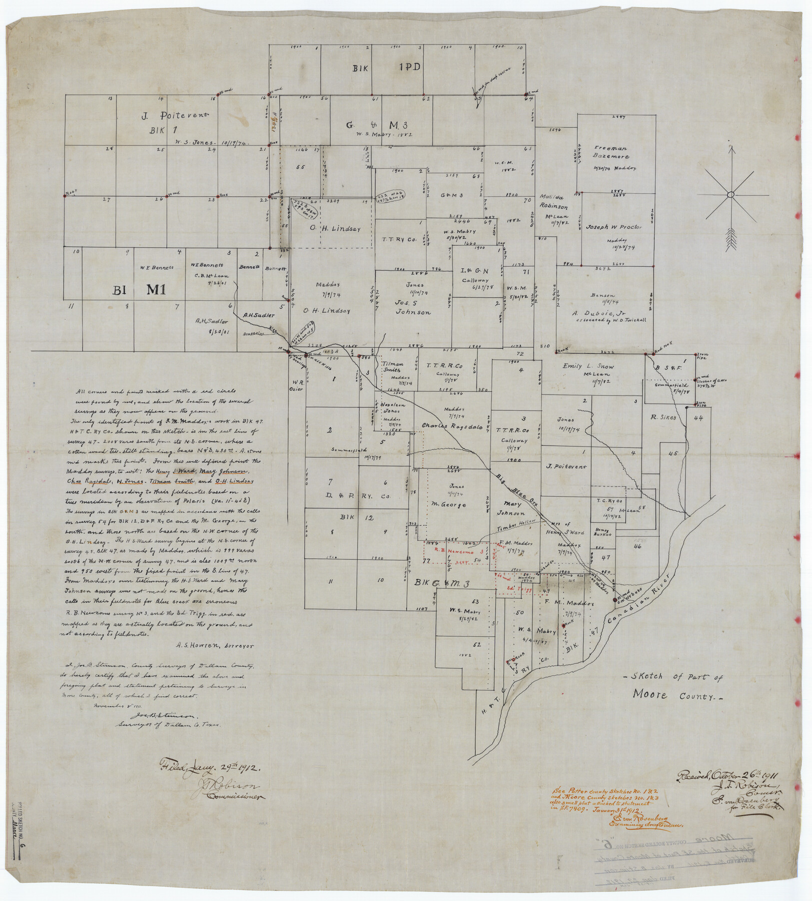
Moore County Rolled Sketch 6
Sketch of part of Moore County
-
Map/Doc
6825
-
Collection
General Map Collection
-
Object Dates
1911/11/8 (Creation Date)
1912/1/29 (File Date)
-
People and Organizations
A.S. Howren (Surveyor/Engineer)
-
Counties
Moore Hutchinson
-
Subjects
Surveying Rolled Sketch
-
Height x Width
33.4 x 30.2 inches
84.8 x 76.7 cm
-
Medium
linen, manuscript
-
Comments
See Moore County Sketch File 14 (31961) for correspondence.
Related maps
Moore County Sketch File 14

Print $4.00
- Digital $50.00
Moore County Sketch File 14
Size 11.2 x 8.8 inches
Map/Doc 31961
Part of: General Map Collection

Panola County Working Sketch 2

Print $20.00
- Digital $50.00
Panola County Working Sketch 2
1920
Map/Doc 71411
Hall County Sketch File 5

Print $20.00
- Digital $50.00
Hall County Sketch File 5
1884
Size 18.9 x 24.1 inches
Map/Doc 11602
Terrell County Rolled Sketch 29

Print $20.00
- Digital $50.00
Terrell County Rolled Sketch 29
1929
Size 27.5 x 41.9 inches
Map/Doc 7936
Shelby County Sketch File 20

Print $20.00
- Digital $50.00
Shelby County Sketch File 20
1879
Size 18.3 x 34.6 inches
Map/Doc 12319
Current Miscellaneous File 30

Print $8.00
- Digital $50.00
Current Miscellaneous File 30
1953
Size 10.6 x 8.2 inches
Map/Doc 73925
Crosby County Working Sketch 16

Print $40.00
- Digital $50.00
Crosby County Working Sketch 16
1979
Size 37.4 x 59.3 inches
Map/Doc 68450
Concho County Sketch File 47

Print $20.00
- Digital $50.00
Concho County Sketch File 47
1950
Size 16.8 x 21.0 inches
Map/Doc 11165
Jack County Sketch File 18b

Print $4.00
- Digital $50.00
Jack County Sketch File 18b
Size 8.0 x 12.9 inches
Map/Doc 27557
Jefferson County Rolled Sketch 44

Print $20.00
- Digital $50.00
Jefferson County Rolled Sketch 44
1957
Size 26.9 x 25.5 inches
Map/Doc 6401
Brazoria County

Print $20.00
- Digital $50.00
Brazoria County
1879
Size 26.6 x 25.1 inches
Map/Doc 859
Moore County Rolled Sketch 11

Print $20.00
- Digital $50.00
Moore County Rolled Sketch 11
Size 34.1 x 43.0 inches
Map/Doc 9549
You may also like
Hemphill County Rolled Sketch 8

Print $20.00
- Digital $50.00
Hemphill County Rolled Sketch 8
1903
Size 22.7 x 30.5 inches
Map/Doc 6191
Flight Mission No. CRC-3R, Frame 54, Chambers County

Print $20.00
- Digital $50.00
Flight Mission No. CRC-3R, Frame 54, Chambers County
1956
Size 18.7 x 22.4 inches
Map/Doc 84826
Hutchinson County Sketch File 33

Print $20.00
- Digital $50.00
Hutchinson County Sketch File 33
1926
Size 26.5 x 24.5 inches
Map/Doc 11821
Galveston County Working Sketch 10

Print $40.00
- Digital $50.00
Galveston County Working Sketch 10
1967
Size 24.7 x 119.8 inches
Map/Doc 69347
Flight Mission No. DAG-17K, Frame 73, Matagorda County

Print $20.00
- Digital $50.00
Flight Mission No. DAG-17K, Frame 73, Matagorda County
1952
Size 18.5 x 22.4 inches
Map/Doc 86332
Armstrong County Working Sketch 1

Print $20.00
- Digital $50.00
Armstrong County Working Sketch 1
1903
Size 10.3 x 17.2 inches
Map/Doc 67232
Jeff Davis County Sketch File 22

Print $20.00
- Digital $50.00
Jeff Davis County Sketch File 22
1923
Size 19.4 x 25.0 inches
Map/Doc 11860
Dallas County

Print $20.00
- Digital $50.00
Dallas County
1942
Size 45.1 x 37.1 inches
Map/Doc 77258
Fayette County Sketch File 6

Print $114.00
- Digital $50.00
Fayette County Sketch File 6
1981
Size 14.9 x 9.5 inches
Map/Doc 22508
Real County Sketch File 18

Print $28.00
- Digital $50.00
Real County Sketch File 18
1964
Size 14.3 x 8.9 inches
Map/Doc 35076
Right of Way and Track Map, the Missouri, Kansas and Texas Ry. of Texas - Henrietta Division

Print $20.00
- Digital $50.00
Right of Way and Track Map, the Missouri, Kansas and Texas Ry. of Texas - Henrietta Division
1918
Size 11.8 x 26.8 inches
Map/Doc 64751