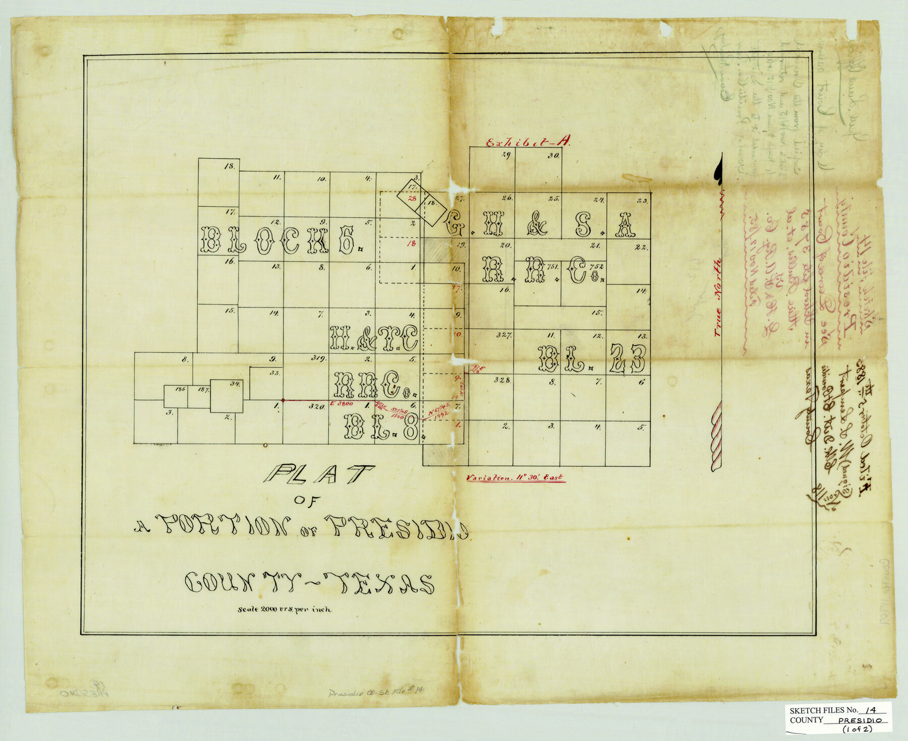
Presidio County Sketch File 14
[Two sketches and field notes of a connecting line southwest of Marfa]
-
Map/Doc
11707
-
Collection
General Map Collection
-
Object Dates
5/12/1883 (Creation Date)
6/6/1883 (File Date)
5/19/1880 (Survey Date)
5/12/1883 (Survey Date)
-
People and Organizations
C.F.H. von Blucher (Compiler)
A.G. Cotera (Compiler)
S.A. Thompson (Surveyor/Engineer)
E.L. Gage (Surveyor/Engineer)
-
Counties
Presidio
-
Subjects
Surveying Sketch File
-
Height x Width
15.3 x 18.8 inches
38.9 x 47.8 cm
-
Medium
paper, manuscript
-
Scale
1" = 2000 varas
-
Features
Old Indian Village
Cibolo Creek
Part of: General Map Collection
Flight Mission No. DQO-8K, Frame 68, Galveston County

Print $20.00
- Digital $50.00
Flight Mission No. DQO-8K, Frame 68, Galveston County
1952
Size 17.3 x 19.5 inches
Map/Doc 85172
Flight Mission No. BQY-15M, Frame 11, Harris County

Print $20.00
- Digital $50.00
Flight Mission No. BQY-15M, Frame 11, Harris County
1953
Size 18.5 x 22.4 inches
Map/Doc 85309
Brown County Sketch File X

Print $4.00
- Digital $50.00
Brown County Sketch File X
1882
Size 8.1 x 11.7 inches
Map/Doc 16580
Presidio County Rolled Sketch 143

Print $20.00
- Digital $50.00
Presidio County Rolled Sketch 143
Size 40.2 x 36.8 inches
Map/Doc 90046
Flight Mission No. CGI-1N, Frame 166, Cameron County

Print $20.00
- Digital $50.00
Flight Mission No. CGI-1N, Frame 166, Cameron County
1955
Size 18.5 x 22.2 inches
Map/Doc 84501
Map of Williamson County

Print $20.00
- Digital $50.00
Map of Williamson County
1880
Size 20.9 x 29.0 inches
Map/Doc 4148
Grimes County Working Sketch 10

Print $20.00
- Digital $50.00
Grimes County Working Sketch 10
1980
Size 21.5 x 29.6 inches
Map/Doc 63301
Presidio County Rolled Sketch 117

Print $20.00
- Digital $50.00
Presidio County Rolled Sketch 117
Size 29.1 x 28.8 inches
Map/Doc 7392
Moore County Sketch File 2

Print $36.00
- Digital $50.00
Moore County Sketch File 2
Size 14.2 x 8.6 inches
Map/Doc 31929
Presidio County Rolled Sketch 131A

Print $3.00
- Digital $50.00
Presidio County Rolled Sketch 131A
Size 15.8 x 9.3 inches
Map/Doc 10708
McLennan County Working Sketch 3

Print $20.00
- Digital $50.00
McLennan County Working Sketch 3
1941
Size 18.0 x 17.9 inches
Map/Doc 70696
Flight Mission No. DAG-23K, Frame 171, Matagorda County

Print $20.00
- Digital $50.00
Flight Mission No. DAG-23K, Frame 171, Matagorda County
1953
Size 18.6 x 22.4 inches
Map/Doc 86509
You may also like
Guadalupe County Sketch File 23

Print $22.00
- Digital $50.00
Guadalupe County Sketch File 23
1859
Size 25.5 x 19.0 inches
Map/Doc 11592
La Salle County Working Sketch 11

Print $20.00
- Digital $50.00
La Salle County Working Sketch 11
1929
Size 29.3 x 20.7 inches
Map/Doc 70312
Grayson County Working Sketch 16

Print $20.00
- Digital $50.00
Grayson County Working Sketch 16
1954
Size 44.2 x 24.7 inches
Map/Doc 63255
San Saba County Working Sketch 13

Print $20.00
- Digital $50.00
San Saba County Working Sketch 13
1995
Size 42.8 x 32.8 inches
Map/Doc 63801
Flight Mission No. CGI-3N, Frame 42, Cameron County

Print $20.00
- Digital $50.00
Flight Mission No. CGI-3N, Frame 42, Cameron County
1954
Size 18.5 x 22.1 inches
Map/Doc 84548
Hays County Rolled Sketch 20A

Print $20.00
- Digital $50.00
Hays County Rolled Sketch 20A
Size 20.7 x 23.9 inches
Map/Doc 6177
[Sketch for Mineral Application 27670 - Strip between Simon Sanchez leagues and Trinity River]
![2862, [Sketch for Mineral Application 27670 - Strip between Simon Sanchez leagues and Trinity River], General Map Collection](https://historictexasmaps.com/wmedia_w700/maps/2862-1.tif.jpg)
Print $20.00
- Digital $50.00
[Sketch for Mineral Application 27670 - Strip between Simon Sanchez leagues and Trinity River]
1934
Size 25.7 x 39.9 inches
Map/Doc 2862
Map of the southern states, including rail roads, county towns, state capitals, count roads, the southern coast from Delaware to Texas, showing the harbors, inlets, forts and position of blockading ships.

Print $20.00
Map of the southern states, including rail roads, county towns, state capitals, count roads, the southern coast from Delaware to Texas, showing the harbors, inlets, forts and position of blockading ships.
1863
Size 20.1 x 29.9 inches
Map/Doc 93571
[Surveys near Onion Creek]
![108, [Surveys near Onion Creek], General Map Collection](https://historictexasmaps.com/wmedia_w700/maps/108-1.tif.jpg)
Print $2.00
- Digital $50.00
[Surveys near Onion Creek]
1841
Size 11.0 x 7.8 inches
Map/Doc 108
Flight Mission No. CRC-1R, Frame 157, Chambers County

Print $20.00
- Digital $50.00
Flight Mission No. CRC-1R, Frame 157, Chambers County
1956
Size 18.8 x 22.5 inches
Map/Doc 84719
Map of Panola County

Print $20.00
- Digital $50.00
Map of Panola County
1897
Size 42.8 x 39.6 inches
Map/Doc 66968
El Paso County Rolled Sketch 66

Print $20.00
- Digital $50.00
El Paso County Rolled Sketch 66
2014
Size 35.1 x 41.2 inches
Map/Doc 93712