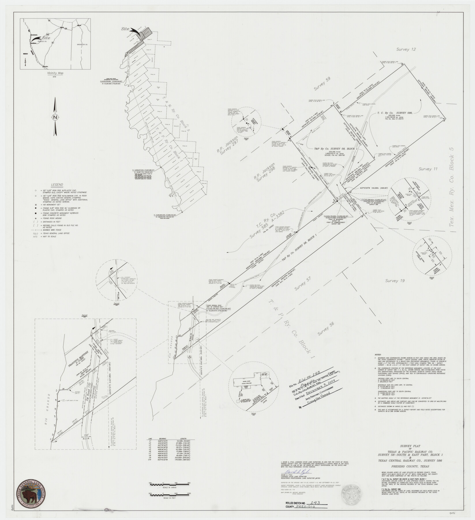
Presidio County Rolled Sketch 143
Survey plat of Texas & Pacific Railway Co. survey 58 - south & east part, Block 1 & Texas Central Railway Co. survey 586, Presidio County, Texas
-
Map/Doc
90046
-
Collection
General Map Collection
-
Object Dates
2007/9/23 (Survey Date)
2009/12/9 (File Date)
-
People and Organizations
Ryan Hancock (Draftsman)
Michael Mokarzel (Draftsman)
David A. Pyle (Surveyor/Engineer)
Richard W. Moffett (Chainman/Field Personnel)
Mark Neugebauer (Chainman/Field Personnel)
Charlie Strauch (Chainman/Field Personnel)
Jason Smalley (Chainman/Field Personnel)
David Holmes (Chainman/Field Personnel)
Willie Miles (Chainman/Field Personnel)
Ryan Hancock (Chainman/Field Personnel)
-
Counties
Presidio
-
Subjects
Surveying Rolled Sketch
-
Height x Width
40.2 x 36.8 inches
102.1 x 93.5 cm
-
Medium
mylar, print
Part of: General Map Collection
[Sketch for Mineral Application 15273 - Sabine River Bed]
![65576, [Sketch for Mineral Application 15273 - Sabine River Bed], General Map Collection](https://historictexasmaps.com/wmedia_w700/maps/65576.tif.jpg)
Print $20.00
- Digital $50.00
[Sketch for Mineral Application 15273 - Sabine River Bed]
1926
Size 45.4 x 28.1 inches
Map/Doc 65576
Haskell County Rolled Sketch 13

Print $3.00
- Digital $50.00
Haskell County Rolled Sketch 13
1991
Size 11.0 x 17.1 inches
Map/Doc 6171
Comal County Sketch File 14

Print $4.00
- Digital $50.00
Comal County Sketch File 14
1867
Size 7.7 x 7.6 inches
Map/Doc 19029
Colorado County Working Sketch 7

Print $20.00
- Digital $50.00
Colorado County Working Sketch 7
1922
Size 23.8 x 23.2 inches
Map/Doc 68107
[Map of the City of South Padre Island]
![3212, [Map of the City of South Padre Island], General Map Collection](https://historictexasmaps.com/wmedia_w700/maps/3212-1.tif.jpg)
Print $20.00
- Digital $50.00
[Map of the City of South Padre Island]
1993
Size 12.5 x 36.5 inches
Map/Doc 3212
Flight Mission No. BQR-20K, Frame 11, Brazoria County

Print $20.00
- Digital $50.00
Flight Mission No. BQR-20K, Frame 11, Brazoria County
1952
Size 18.7 x 22.3 inches
Map/Doc 84113
Calhoun County Rolled Sketch 11

Print $20.00
- Digital $50.00
Calhoun County Rolled Sketch 11
1942
Size 12.8 x 41.9 inches
Map/Doc 5368
[Sketch for Mineral Application 24072, San Jacinto River]
![65589, [Sketch for Mineral Application 24072, San Jacinto River], General Map Collection](https://historictexasmaps.com/wmedia_w700/maps/65589.tif.jpg)
Print $20.00
- Digital $50.00
[Sketch for Mineral Application 24072, San Jacinto River]
1929
Size 29.6 x 14.7 inches
Map/Doc 65589
Blanco County Working Sketch 3

Print $20.00
- Digital $50.00
Blanco County Working Sketch 3
Size 14.4 x 16.1 inches
Map/Doc 78189
Coke County Rolled Sketch 33

Print $20.00
- Digital $50.00
Coke County Rolled Sketch 33
2004
Size 28.9 x 40.5 inches
Map/Doc 82987
Flight Mission No. DQO-2K, Frame 165, Galveston County

Print $20.00
- Digital $50.00
Flight Mission No. DQO-2K, Frame 165, Galveston County
1952
Size 18.9 x 22.4 inches
Map/Doc 85054
Flight Mission No. BRA-16M, Frame 111, Jefferson County

Print $20.00
- Digital $50.00
Flight Mission No. BRA-16M, Frame 111, Jefferson County
1953
Size 18.5 x 22.2 inches
Map/Doc 85721
You may also like
[Surveys in the Bexar District along the Cibolo Creek]
![98, [Surveys in the Bexar District along the Cibolo Creek], General Map Collection](https://historictexasmaps.com/wmedia_w700/maps/98.tif.jpg)
Print $2.00
- Digital $50.00
[Surveys in the Bexar District along the Cibolo Creek]
1847
Size 13.0 x 7.4 inches
Map/Doc 98
Geographical Observations on the Inner Margins of the Border and Coastal Reserves of Texas, 1824-1836

Geographical Observations on the Inner Margins of the Border and Coastal Reserves of Texas, 1824-1836
2022
Map/Doc 97131
Flight Mission No. DAG-24K, Frame 159, Matagorda County

Print $20.00
- Digital $50.00
Flight Mission No. DAG-24K, Frame 159, Matagorda County
1953
Size 17.2 x 19.1 inches
Map/Doc 86573
Val Verde County Sketch File B1

Print $20.00
- Digital $50.00
Val Verde County Sketch File B1
1905
Size 21.3 x 20.7 inches
Map/Doc 12543
Stephens County Sketch File 26

Print $10.00
- Digital $50.00
Stephens County Sketch File 26
Size 14.1 x 8.8 inches
Map/Doc 37096
Encinal County

Print $20.00
- Digital $50.00
Encinal County
1895
Size 34.4 x 24.0 inches
Map/Doc 3516
Uvalde County Rolled Sketch 18

Print $20.00
- Digital $50.00
Uvalde County Rolled Sketch 18
Size 33.2 x 24.8 inches
Map/Doc 8102
Calhoun County Rolled Sketch 12

Print $40.00
- Digital $50.00
Calhoun County Rolled Sketch 12
1940
Size 37.9 x 54.6 inches
Map/Doc 66845
Sulphur River, Dunbar Creek Sheet

Print $4.00
- Digital $50.00
Sulphur River, Dunbar Creek Sheet
1941
Size 17.2 x 20.9 inches
Map/Doc 65174
Pecos County Rolled Sketch 191

Print $20.00
- Digital $50.00
Pecos County Rolled Sketch 191
Size 18.2 x 27.4 inches
Map/Doc 95397
Upton County Working Sketch 49B

Print $20.00
- Digital $50.00
Upton County Working Sketch 49B
1979
Size 19.0 x 32.0 inches
Map/Doc 69546
A Map of the United States including Louisiana

Print $20.00
- Digital $50.00
A Map of the United States including Louisiana
1817
Size 14.9 x 18.2 inches
Map/Doc 95964