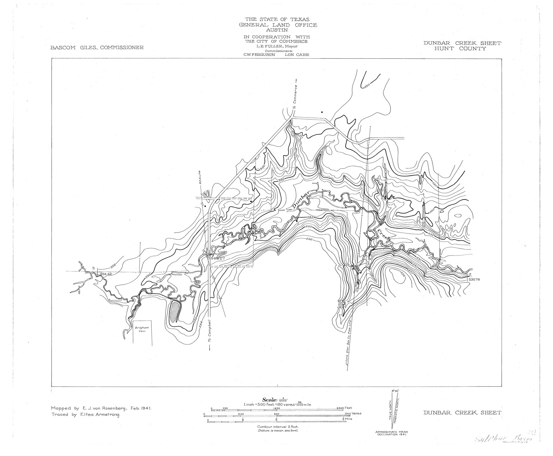
Sulphur River, Dunbar Creek Sheet
-
Map/Doc
65174
-
Collection
General Map Collection
-
Object Dates
1941 (Creation Date)
-
People and Organizations
Texas General Land Office (Publisher)
Eltea Armstrong (Draftsman)
Ernest J. von Rosenberg (Compiler)
Bascom Giles (GLO Commissioner)
-
Counties
Hunt
-
Subjects
River Surveys Topographic
-
Height x Width
17.2 x 20.9 inches
43.7 x 53.1 cm
Part of: General Map Collection
Crockett County Rolled Sketch 60

Print $20.00
- Digital $50.00
Crockett County Rolled Sketch 60
Size 18.7 x 18.9 inches
Map/Doc 5603
Henderson County

Print $40.00
- Digital $50.00
Henderson County
1988
Size 30.8 x 63.0 inches
Map/Doc 77310
Flight Mission No. DQN-5K, Frame 50, Calhoun County

Print $20.00
- Digital $50.00
Flight Mission No. DQN-5K, Frame 50, Calhoun County
1953
Size 18.5 x 22.3 inches
Map/Doc 84395
Garza County Sketch File 2

Print $20.00
- Digital $50.00
Garza County Sketch File 2
Size 33.1 x 30.3 inches
Map/Doc 10462
Map of Bee County

Print $20.00
- Digital $50.00
Map of Bee County
1879
Size 25.1 x 22.7 inches
Map/Doc 3289
Cameron County Sketch File 12

Print $222.00
- Digital $50.00
Cameron County Sketch File 12
Size 10.8 x 7.4 inches
Map/Doc 17236
Atascosa County Rolled Sketch 20A

Print $20.00
- Digital $50.00
Atascosa County Rolled Sketch 20A
Size 41.8 x 32.8 inches
Map/Doc 10224
Reeves County Rolled Sketch 6

Print $20.00
- Digital $50.00
Reeves County Rolled Sketch 6
Size 22.6 x 29.0 inches
Map/Doc 7478
Flight Mission No. CLL-1N, Frame 193, Willacy County

Print $20.00
- Digital $50.00
Flight Mission No. CLL-1N, Frame 193, Willacy County
1954
Size 18.4 x 22.2 inches
Map/Doc 87063
Guadalupe County

Print $20.00
- Digital $50.00
Guadalupe County
1877
Size 21.5 x 21.4 inches
Map/Doc 3608
Cooke County Sketch File 11

Print $4.00
- Digital $50.00
Cooke County Sketch File 11
1858
Size 12.4 x 8.2 inches
Map/Doc 19244
Uvalde County Working Sketch 58

Print $20.00
- Digital $50.00
Uvalde County Working Sketch 58
1968
Size 29.3 x 23.3 inches
Map/Doc 72128
You may also like
Map of east part of West Bay & SW part of Galveston Bay, Galveston County showing subdivision for mineral development

Print $40.00
- Digital $50.00
Map of east part of West Bay & SW part of Galveston Bay, Galveston County showing subdivision for mineral development
1963
Size 64.1 x 45.4 inches
Map/Doc 3079
Refugio County Sketch File 10

Print $4.00
- Digital $50.00
Refugio County Sketch File 10
Size 8.2 x 9.4 inches
Map/Doc 35258
Record of Spanish Titles, Vol. V

Record of Spanish Titles, Vol. V
1845
Size 16.4 x 12.3 inches
Map/Doc 94530
Kleberg County Rolled Sketch 10-19

Print $20.00
- Digital $50.00
Kleberg County Rolled Sketch 10-19
1952
Size 38.2 x 36.7 inches
Map/Doc 9379
Baylor County Sketch File 7

Print $4.00
- Digital $50.00
Baylor County Sketch File 7
Size 6.7 x 10.2 inches
Map/Doc 14135
[Northwest corner of the County]
![90873, [Northwest corner of the County], Twichell Survey Records](https://historictexasmaps.com/wmedia_w700/maps/90873-2.tif.jpg)
Print $20.00
- Digital $50.00
[Northwest corner of the County]
1903
Size 19.1 x 21.5 inches
Map/Doc 90873
Outer Continental Shelf Leasing Maps (Louisiana Offshore Operations)

Print $20.00
- Digital $50.00
Outer Continental Shelf Leasing Maps (Louisiana Offshore Operations)
1959
Size 17.9 x 13.8 inches
Map/Doc 76101
Morris County Rolled Sketch 2A

Print $20.00
- Digital $50.00
Morris County Rolled Sketch 2A
Size 24.3 x 19.1 inches
Map/Doc 10242
Edwards County Working Sketch 65

Print $20.00
- Digital $50.00
Edwards County Working Sketch 65
1956
Size 34.0 x 25.0 inches
Map/Doc 68941
Sterling County Rolled Sketch 33

Print $20.00
- Digital $50.00
Sterling County Rolled Sketch 33
Size 16.6 x 12.3 inches
Map/Doc 7857
Flight Mission No. BRA-7M, Frame 200, Jefferson County

Print $20.00
- Digital $50.00
Flight Mission No. BRA-7M, Frame 200, Jefferson County
1953
Size 18.8 x 22.4 inches
Map/Doc 85568
Oldham County Rolled Sketch 2

Print $40.00
- Digital $50.00
Oldham County Rolled Sketch 2
1886
Size 35.7 x 55.1 inches
Map/Doc 9639