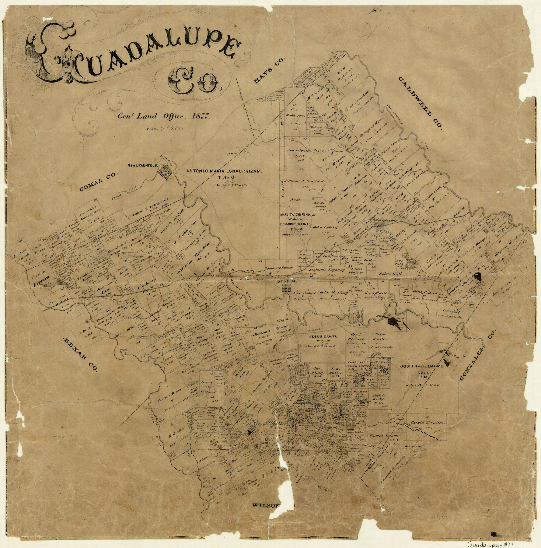
Guadalupe County
-
Map/Doc
3608
-
Collection
General Map Collection
-
Object Dates
1877 (Creation Date)
-
People and Organizations
F.G. Blau (Draftsman)
-
Counties
Guadalupe
-
Subjects
County
-
Height x Width
21.5 x 21.4 inches
54.6 x 54.4 cm
-
Features
Guadalupe River
Sandy Creek
Eclato Creek
Sandy Fork
Elm Creek
Cibolo River
Castleman's Creek
Nash Creek
Mill Creek
Mill Road
Gonzales Road
Manchaca Creek
Cottonwood Creek
Seguin Road
Santa Clara Creek
New Braunfels
Comal Creek
Comal River
Highsmiths Creek
Seguin
Kingsbury
Panete Creek
Yorks Creek
San Marcos River
Part of: General Map Collection
Crockett County Sketch File HH

Print $38.00
- Digital $50.00
Crockett County Sketch File HH
Size 13.8 x 8.9 inches
Map/Doc 19641
Pecos County Rolled Sketch 179

Print $20.00
- Digital $50.00
Pecos County Rolled Sketch 179
1980
Size 28.0 x 28.2 inches
Map/Doc 7299
[Right of Way & Track Map, The Texas & Pacific Ry. Co. Main Line]
![64668, [Right of Way & Track Map, The Texas & Pacific Ry. Co. Main Line], General Map Collection](https://historictexasmaps.com/wmedia_w700/maps/64668.tif.jpg)
Print $20.00
- Digital $50.00
[Right of Way & Track Map, The Texas & Pacific Ry. Co. Main Line]
Size 11.0 x 18.4 inches
Map/Doc 64668
Pecos County Rolled Sketch 117

Print $40.00
- Digital $50.00
Pecos County Rolled Sketch 117
1944
Size 44.6 x 52.6 inches
Map/Doc 9722
Ward County Rolled Sketch 7

Print $40.00
- Digital $50.00
Ward County Rolled Sketch 7
1907
Size 33.9 x 91.0 inches
Map/Doc 10103
Mineral Plats - El Paso to Ward Co. and River Beds

Mineral Plats - El Paso to Ward Co. and River Beds
Map/Doc 81746
Karnes County Working Sketch 3

Print $20.00
- Digital $50.00
Karnes County Working Sketch 3
1943
Size 34.6 x 31.4 inches
Map/Doc 66651
Edwards County Sketch File 14

Print $24.00
- Digital $50.00
Edwards County Sketch File 14
1891
Size 12.9 x 8.7 inches
Map/Doc 21703
Flight Mission No. BRA-8M, Frame 24, Jefferson County

Print $20.00
- Digital $50.00
Flight Mission No. BRA-8M, Frame 24, Jefferson County
1953
Size 18.7 x 22.3 inches
Map/Doc 85579
Map of Stephens Buchanan County north of the Clearfork of the Brazos River, Young- the balance Milam- Land- District

Print $20.00
- Digital $50.00
Map of Stephens Buchanan County north of the Clearfork of the Brazos River, Young- the balance Milam- Land- District
1859
Size 24.4 x 19.6 inches
Map/Doc 4052
Clay County Sketch File 31

Print $4.00
- Digital $50.00
Clay County Sketch File 31
Size 10.2 x 8.0 inches
Map/Doc 18456
Bandera County Sketch File 31

Print $40.00
- Digital $50.00
Bandera County Sketch File 31
1949
Size 17.7 x 22.2 inches
Map/Doc 10900
You may also like
Wichita County Rolled Sketch 14

Print $20.00
- Digital $50.00
Wichita County Rolled Sketch 14
1927
Size 36.7 x 30.5 inches
Map/Doc 8251
[Tom Green County]
![16901, [Tom Green County], General Map Collection](https://historictexasmaps.com/wmedia_w700/maps/16901.tif.jpg)
Print $20.00
- Digital $50.00
[Tom Green County]
1888
Size 33.2 x 34.4 inches
Map/Doc 16901

General Highway Map, Matagorda County, Texas

Print $20.00
General Highway Map, Matagorda County, Texas
1961
Size 24.8 x 18.2 inches
Map/Doc 79585
Wilson County Working Sketch 9

Print $20.00
- Digital $50.00
Wilson County Working Sketch 9
1979
Size 31.6 x 33.0 inches
Map/Doc 72589
Garza County Working Sketch 5

Print $20.00
- Digital $50.00
Garza County Working Sketch 5
1943
Size 19.4 x 34.7 inches
Map/Doc 63152
Brewster County Working Sketch 82

Print $20.00
- Digital $50.00
Brewster County Working Sketch 82
1973
Size 45.3 x 36.6 inches
Map/Doc 67682
Hardeman County Sketch File 2

Print $6.00
- Digital $50.00
Hardeman County Sketch File 2
1879
Size 9.0 x 7.7 inches
Map/Doc 24984
Navarro County Working Sketch 7

Print $20.00
- Digital $50.00
Navarro County Working Sketch 7
1950
Size 28.2 x 23.4 inches
Map/Doc 71237
Scurry County Working Sketch 5

Print $40.00
- Digital $50.00
Scurry County Working Sketch 5
1950
Size 72.5 x 27.8 inches
Map/Doc 63834
Wilson Strickland Survey, Exhibit A

Print $20.00
- Digital $50.00
Wilson Strickland Survey, Exhibit A
Size 20.8 x 23.0 inches
Map/Doc 91368
Texas Prospectors and Historians Map

Digital $50.00
Texas Prospectors and Historians Map
Size 22.4 x 29.2 inches
Map/Doc 94411