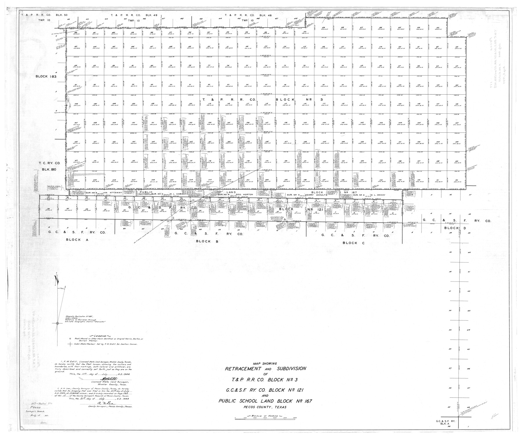
Pecos County Rolled Sketch 117
Map showing retracement and subdivision of T. & P. R.R. Co. Block no. 3, G. C. & S. F. Ry. Co. Block no. 121 and Public School Land Block no. 167
-
Map/Doc
9722
-
Collection
General Map Collection
-
Object Dates
1944/7/17 (Creation Date)
1944/8/5 (File Date)
-
People and Organizations
F.W. Estill (Surveyor/Engineer)
-
Counties
Pecos
-
Subjects
Surveying Rolled Sketch
-
Height x Width
44.6 x 52.6 inches
113.3 x 133.6 cm
Part of: General Map Collection
Roberts County Rolled Sketch 3

Print $40.00
- Digital $50.00
Roberts County Rolled Sketch 3
Size 38.0 x 49.7 inches
Map/Doc 8354
Pecos County Rolled Sketch JAS-1A

Print $40.00
- Digital $50.00
Pecos County Rolled Sketch JAS-1A
1960
Size 43.5 x 63.3 inches
Map/Doc 9746
Kimble County Working Sketch 93

Print $20.00
- Digital $50.00
Kimble County Working Sketch 93
1983
Size 31.5 x 37.8 inches
Map/Doc 70161
Pecos County Rolled Sketch 152

Print $20.00
- Digital $50.00
Pecos County Rolled Sketch 152
1960
Size 38.8 x 43.7 inches
Map/Doc 9736
Knox County Boundary File 5

Print $14.00
- Digital $50.00
Knox County Boundary File 5
Size 14.2 x 8.6 inches
Map/Doc 65040
Haskell County Rolled Sketch 3

Print $20.00
- Digital $50.00
Haskell County Rolled Sketch 3
1902
Size 18.1 x 21.0 inches
Map/Doc 6164
Galveston County NRC Article 33.136 Sketch 8

Print $20.00
- Digital $50.00
Galveston County NRC Article 33.136 Sketch 8
2002
Size 32.3 x 26.0 inches
Map/Doc 61590
Cameron County Rolled Sketch 25

Print $20.00
- Digital $50.00
Cameron County Rolled Sketch 25
1977
Size 24.7 x 36.7 inches
Map/Doc 5795
Nacogdoches County Sketch File 11

Print $2.00
- Digital $50.00
Nacogdoches County Sketch File 11
Size 8.0 x 8.8 inches
Map/Doc 32255
Young County Rolled Sketch 17

Print $20.00
- Digital $50.00
Young County Rolled Sketch 17
1984
Size 17.5 x 24.0 inches
Map/Doc 8305
Clay County Sketch File 17

Print $4.00
- Digital $50.00
Clay County Sketch File 17
1855
Size 6.8 x 8.7 inches
Map/Doc 18425
Topographical Map of the Rio Grande, Sheet No. 21

Print $20.00
- Digital $50.00
Topographical Map of the Rio Grande, Sheet No. 21
1912
Map/Doc 89545
You may also like
Pecos County Sketch File 69

Print $6.00
- Digital $50.00
Pecos County Sketch File 69
Size 11.1 x 8.8 inches
Map/Doc 33869
Sketch of a portion of the Texas Coast showing the relative positions of different harbours with the interior Military Posts, and the roads communicating with them, also two new routes from Black Point and Lamar to San Antonio

Print $20.00
- Digital $50.00
Sketch of a portion of the Texas Coast showing the relative positions of different harbours with the interior Military Posts, and the roads communicating with them, also two new routes from Black Point and Lamar to San Antonio
1855
Size 27.3 x 18.3 inches
Map/Doc 72710
[University Blocks 17 and 18, Block Z, C4, 194, 178, A2, C3]
![93199, [University Blocks 17 and 18, Block Z, C4, 194, 178, A2, C3], Twichell Survey Records](https://historictexasmaps.com/wmedia_w700/maps/93199-1.tif.jpg)
Print $40.00
- Digital $50.00
[University Blocks 17 and 18, Block Z, C4, 194, 178, A2, C3]
1882
Size 81.8 x 54.1 inches
Map/Doc 93199
Harris County Rolled Sketch 86

Print $40.00
- Digital $50.00
Harris County Rolled Sketch 86
Size 50.4 x 43.9 inches
Map/Doc 73581
Bandera County Sketch File 33

Print $40.00
- Digital $50.00
Bandera County Sketch File 33
1975
Size 14.4 x 17.5 inches
Map/Doc 14028
Harris County

Print $20.00
- Digital $50.00
Harris County
1940
Size 36.6 x 45.1 inches
Map/Doc 73172
DeWitt County Sketch File 1

Print $11.00
- Digital $50.00
DeWitt County Sketch File 1
1851
Size 8.4 x 8.2 inches
Map/Doc 20794
Potter County Sketch File 19

Print $20.00
- Digital $50.00
Potter County Sketch File 19
Size 23.7 x 15.5 inches
Map/Doc 12202
Brewster County Sketch File NS-12

Print $40.00
- Digital $50.00
Brewster County Sketch File NS-12
Size 18.0 x 23.0 inches
Map/Doc 10990
Flight Mission No. DQO-7K, Frame 80, Galveston County

Print $20.00
- Digital $50.00
Flight Mission No. DQO-7K, Frame 80, Galveston County
1952
Size 18.8 x 22.4 inches
Map/Doc 85107
Freestone County Sketch File 15

Print $4.00
- Digital $50.00
Freestone County Sketch File 15
Size 6.3 x 8.2 inches
Map/Doc 23070
Dallas County Working Sketch 1

Print $20.00
- Digital $50.00
Dallas County Working Sketch 1
Size 41.4 x 28.3 inches
Map/Doc 68567